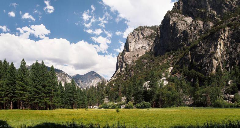
Zumwalt Meadow
check with the trail manager for updated details before visiting.
Zumwalt Meadow
National Park Service
Backcountry Trail
- Length
1.5 miles
- Elevation Gain
--
- Route Type
out & back
- Length
1.5 miles - Elevation Gain
-- - Route Type
out & back
Circular, mostly level path around a tall grass meadow; excellent views of the Kings River and the high mountains bordering Kings Canyon
Location: In Kings Canyon NP, 3 mi. E of Cedar Grove Village.
- States: California
- Counties: Tulare
Zumwalt Meadow provides visitors with a scenic contrast to the powerful rock formations deep in the heart of the canyon. Glorious and lush in spring, and splendid in summer and fall, Zumwalt Meadow is a spectacular alpine setting.
A scenic, 1.5-mile self-guided trail circles the area and offers magnificent views of high granite walls, verdant meadows, and the free-flowing Kings River. With its flat, gentle trails, the meadow is great for kids and makes an ideal introduction to the park. Many rangers say this is the best (and most popular) day hike in the Cedar Grove area. Parking for Kings Canyon's Zumwalt Meadow is available four miles east of the Cedar Grove Village turn-off.
Accessibility Information
No text provided.
Allowed Uses:
Hiking/WalkingPublic Contact
Becky SessionsSequoia and King's Canyon Nat. Park
P.O. Box 926
Three Rivers, CA 93633
(559) 565-3723
Contact the trail manager for current maps and visiting details.
More Details
- Elevation (low): --
- Elevation (high): --
- Elevation (cumulative): --
- Part of a Trail System? No
- Surface (primary): --
- Surfaces (additional): --
- Tread Width (average): 0"
- Tread Width (minimum): --
- Running length (minimum): --
- Tread Grade (average, percent): --
- Tread Grade (maximum):
- Running length (maximum): --
- Cross-slope (average, percent): --
- Cross-slope (maximum): --
- Running length (maximum): --
- Certified as an NRT
Feb 4, 1982