Yellow Rock Trail
check with the trail manager for updated details before visiting.
Yellow Rock Trail
State
Backcountry Trail
- Length
2.5 miles
- Elevation Gain
--
- Route Type
Loop
- Length
2.5 miles - Elevation Gain
-- - Route Type
Loop
On this trail, you will hike 300 feet in elevation to one of the best views in the park.

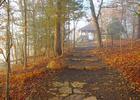
The CCC overlook at the top end of the Yellow Rock Trail in Devil's Den State Park, Arkansas, viewed through light fog moments a. Photo by Sam Wilson.
Location: Devil's Den State Park, 15 miles south of Fayetville on U.S. Highway 71.
- States: Arkansas
- Counties: Washington
On this trail, you will hike 300 feet in elevation to one of the best views in the park. Atop the Yellow Rock, you will have an unobstructed view of the Lee Creek valley. Along the rest of the trail, you will see cedar glades, interesting rock formations, and the first structure built in the park.
There are two ways to access this trail. There is a trailhead on the road going to Campground A. You can also access this trail from the Overlook on Hwy 170. The hike from the Campground A Trailhead to Yellow Rock and back is about 1-1/2 miles and gains 300 feet in elevation. If you hike the loop at the top all the way to the Overlook and return, your distance is about 2-1/2 miles. If you start at the Overlook Trailhead, hike to Yellow Rock, and return via the loop, the hike is about 2 miles with less than 100 feet in elevation gain.
Accessibility Information
No text provided.
Allowed Uses:
Hiking/WalkingPublic Contact
Devil's Den State Park11333 West Arkansas Highway 74
West Fork, AR 72774
[email protected] • (479) 761-3325
www.arkansasstateparks.com/devilsden/hiking
Contact the trail manager for current maps and visiting details.
More Details
- Elevation (low): 1033
- Elevation (high): 1417
- Elevation (cumulative): --
- Part of a Trail System? No
- Surface (primary): Soil
- Surfaces (additional): Rock, boulders, Rock, smooth
- Tread Width (average): 0"
- Tread Width (minimum): --
- Running length (minimum): --
- Tread Grade (average, percent): 11
- Tread Grade (maximum):
- Running length (maximum): --
- Cross-slope (average, percent): --
- Cross-slope (maximum): --
- Running length (maximum): --
- Certified as an NRT
Mar 7, 1978