Wilson's Creek Greenway
check with the trail manager for updated details before visiting.
Wilson's Creek Greenway
City, Town, or County
Frontcountry Trail
Urban Trail
- Length
5 miles
- Elevation Gain
--
- Route Type
out & back
- Length
5 miles - Elevation Gain
-- - Route Type
out & back
The 5-mile Wilson's Creek Greenway is the newest extension of a growing urban trail network in Springfield, Missouri, being developed by citizen organization, Ozark Greenways. This beautiful paved trail allows people of all ages and abilities to conveniently access the woods and pastureland of the Ozarks, for active transportation, bicycling, walking, running, skating and wheelchair use.

People of all ages and backgrounds love the trail!. Photo by Aaron J. Scott
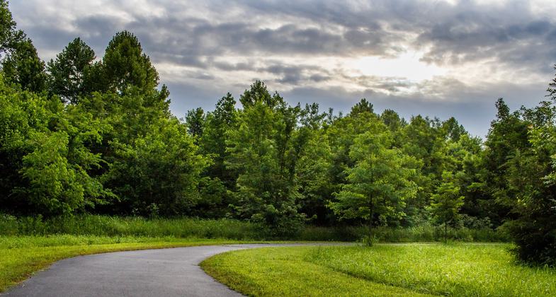
Evening light on Wilson's Creek. Photo by Allin Sorenson.

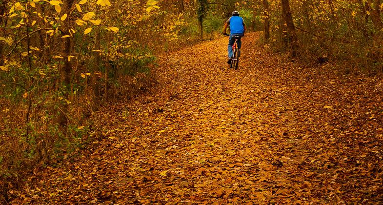
Fall biking on the Wilson's Creek Greenway Trail. Photo by Allin Sorenson.

Location: On the west side of Springfield, Missouri, along Wilson's Creek
- States: Missouri
- Counties: Greene
- Cities/Townships: Springfield
The 5-mile Wilson's Creek Greenway is the newest extension of a growing urban trail network in Springfield, Missouri, being developed by citizen organization, Ozark Greenways. This beautiful paved trail allows people of all ages and abilities to conveniently access the woods and pastureland of the Ozarks, for active transportation, bicycling, walking, running, skating, and wheelchair use.
We're winding down our 25th year as a non-profit citizens organization. It's been inspiring to reflect on what we've accomplished since 1991! We continue to work toward our goal to build a comprehensive network of urban trails to connect more people and places. We reached a milestone in 2016 with 70 miles of greenway trails to date!
On National Trails Day in June, we opened a new portion of Wilson's Creek Greenway - creating one of the most valuable connections in our city so far linking to the popular 8-mile South Creek Greenway (National Recreation Trail, 2009). We hope to extend Wilson's Creek Greenway north to downtown and Jordan Creek Greenway, and eventually south to Wilson's Creek National Battlefield (a large preserved site of one of the most significant Civil War battles). These connections are forming the backbone of a wider network, accessible to all. The natural Wilson's Creek is a community feature once again, as a beautiful stream, filtering our water and air, and sustaining life. We're happy our community leaders are beginning to understand the importance of extending our trail network in a way that stimulates our economy with huge payback in quality of life benefits. There is much more to do, and this designation would help tremendously in keeping up the momentum in the minds of local residents and leaders - hopefully leading to funding and planning of more trails.
The new connection of Wilson's Creek Greenway brings us to a tipping point with trail connectivity in Springfield and Greene County. Along the route, there are schools, universities, parks, churches, restaurants, entertainment venues, coffee shops, breweries, theaters, cultural centers, museums, shopping areas, and much more. There are several outstanding destinations along the trail, including a creek-themed mosaic embedded in the trail by local artist, Christine Schilling; a connection to naturalized South Creek and its monarch butterfly habitat; Rutledge-Wilson Farm Park; Springfield Botanical Center; Nathanael-Greene Park; Close Memorial Park/Drummond Lake; Mizumoto Japanese Garden; Gray-Campbell Pioneer Farmstead; Horton Smith Golf Course; Golden Avenue Prairie; Missouri State University Darr Agriculture Center and horse arena. It also connects to our community's bus and on-street bike route networks.
A long list of community benefits has followed as the trails have developed. There's the usual fun and fitness, but now we're seeing the benefits of more people choosing to bike to work and walk to school. The trail is an example of how community design has the power to improve people's lives. This trail's users have exploded already just since June. Many new trail users have come out, gaining a sense of ownership of their trail.
The trail is a vital connection between neighborhoods, schools, businesses, and shopping areas in one of the most rapidly growing parts of the country. It's close to home for residents, and attractive to visitors. It connects the west part of our city which includes a low-income population. We're pleased to be a resource for all demographics. The trail plays a role in important social interaction, community pride, and boosting mental health. People are getting out of their cars and meeting face-to-face. Many have not used trails before now, and they're embracing an appreciation for the Ozark's natural environment and for each other.
One of the most unique components of this trail is the long list of diverse partners! Ozark Greenways is fortunate that the trail appeals to everyone - all ages, abilities, income levels, backgrounds, and political tastes. We've been thrilled to work with the following businesses, public agencies, individuals, groups, and families to create Wilson's Creek Greenway. Funding is very hard to come by for trail building currently, even with the strong demand for them, so with the help of these supporters, we saved tens of thousands of dollars building Wilson's Creek Greenway. A National Recreation Trail designation would further help our efforts with fundraising.
- Missouri Department of Natural Resources. This trail is an RTP project!
- Springfield-Greene County Park Board. Manages the trails as an integrated part of their city-county park system
- Springfield Public Works' Environmental Services. Transported gravel for construction
- Ozark Greenways" In-kind staff time for project management, fundraising, promotion, signage, public education
- Greene County Highway Department. Built the trail
- O'Reilly and Wooten Families (Owners of O'Reilly Auto Parts). Donated $100,000, to build Tal's Trailhead in memory of their beloved family member and trail supporter, Tal Wooten
- Conco Companies. Donated 1,000 tons of gravel for construction
- Christine Schilling. A local mosaic artist gave us a large discount
- Missouri Division of Youth Services. Troubled youth framed the concrete gazebo pad and assembled the gazebo
- Advanced Concrete Technologies. Poured and finished concrete gazebo pad at Tal's Trailhead
- Greater Springfield Board of Realtors. Provided donations for two interpretive kiosks and three benches
- James River Basin Partnership. Provided two public education water quality kiosks
Accessibility Information
No text provided.
Allowed Uses:
Bicycling Dogs, on leash Hiking/WalkingOther Activities
- Heritage and history
- Snow, snow play general
- Wildlife viewing / observation
Public Contact
Jenny EdwardsSpringfield-Greene County Park Board
1923 N. Weller
Springfield, MO 65802
[email protected] • (417) 864-1049
Contact the trail manager for current maps and visiting details.
More Details
- Elevation (low): 1170
- Elevation (high): 1200
- Elevation (cumulative): --
- Part of a Trail System? No
- Surface (primary): Paved
- Surfaces (additional): Paved
- Tread Width (average): 120"
- Tread Width (minimum): 120
- Running length (minimum): --
- Tread Grade (average, percent): 1
- Tread Grade (maximum): 3
- Running length (maximum): --
- Cross-slope (average, percent): 0
- Cross-slope (maximum): --
- Running length (maximum): --
- Certified as an NRT
May 16, 2018