Wild Bill's Lake
check with the trail manager for updated details before visiting.
Wild Bill's Lake
USDA Forest Service
Urban Trail
- Length
0.5 miles
- Elevation Gain
--
- Route Type
out & back
(1 review)
- Length
0.5 miles - Elevation Gain
-- - Route Type
out & back
Wild Bill Lake is a small but beautiful lake located on the West Fork of Rock Creek Road.
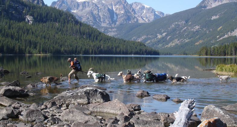
Goatpacking hiking trip. Photo by Beth Shumate.

Photo by Kasie Haack.

Photo by Kasie Haack.

Photo by Kasie Haack.

Photo by Kasie Haack.

Photo by Kasie Haack.

Picnic area. Photo by Kasie Haack.

Barrier free trail. Photo by Kasie Haack.

Photo by Kasie Haack.

Wild Bill Lake. Photo by Kasie Haack.
Location: 7 miles west of Red Lodge, MT., In Custer National Forest, 8 mi. W of Red Lodge on West Fork Rock Creek Road.
- States: Montana
- Counties: Carbon
Wild Bill Lake is a small but beautiful lake located on the West Fork of Rock Creek Road. The picnic area is for day use only. There are four picnic sites available on a first-come, first-serve basis. The Wild Bill National Recreation Trail (# 62) is 0.4 miles and circles around the lake and two fishing docks. The trail is specifically designed as a barrier-free area with wide hard surface paths around approximately half the lake. There are 2 wheelchair-accessible fishing decks, as well as wheelchair-accessible picnic tables and toilets.
The lake is stocked multiple times a year with rainbow trout and is a family-friendly fishing location. There is ample parking.
Accessibility Information
No text provided.
Reviews
Kasie Haack
ADA Accessible
Found this to be a popular destination for families and fishing. There was even a wedding going on. So I had to change plans and come back the next day. Really was impressed with the bathrooms, picnic area and 1/3 of the trail being setup to accommodate wheelchairs. Its great to see that more of our outdoor destinations are becoming more accessible. The loop around the lake is excellent for all skill levels and provides many viewing options of the lake and surrounding mountains. Great lunch destination.
Allowed Uses:
Swimming Dogs, on leash Hiking/WalkingOther Activities
- Fishing
- Wildlife viewing / observation
Public Contact
Allie WoodBeartooth Ranger District
HC 49 Box 3420
Red Lodge, MT 59068
(406) 446-2103
www.fs.fed.us/r1/custer
Contact the trail manager for current maps and visiting details.
More Details
- Elevation (low): 6800
- Elevation (high): 6760
- Elevation (cumulative): --
- Part of a Trail System? No
- Surface (primary): Rock, crushed
- Surfaces (additional): Rock, crushed
- Tread Width (average): 48"
- Tread Width (minimum): --
- Running length (minimum): --
- Tread Grade (average, percent): 1
- Tread Grade (maximum): 1
- Running length (maximum): --
- Cross-slope (average, percent): --
- Cross-slope (maximum): --
- Running length (maximum): --
- Certified as an NRT
Sep 19, 1979