Three Rivers Heritage Trail
check with the trail manager for updated details before visiting.
Three Rivers Heritage Trail
Nonprofit
Frontcountry Trail
Rail Trail
Urban Trail
- Length
25 miles
- Elevation Gain
--
- Route Type
out & back
- Length
25 miles - Elevation Gain
-- - Route Type
out & back
The Three Rivers Heritage Trail is an urban rail-trail paralleling the riverbanks in the Pittsburgh area for about 25 miles, often on both sides of the rivers, and offering a spectacular view of the city.
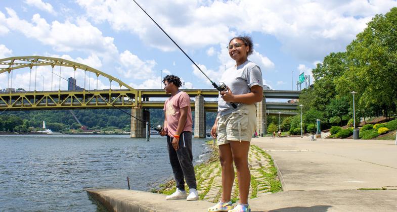
2023 Photo Contest Winner: Urban Trails and Greenways. Photo by Samone Riddle

Winner 2024 NRT Photo Contest, Urban Trails and Greenways

Downtown from Carnegie Science Center. Photo by Mary Shaw.

Trolley at Station Square Section of the trail. Photo by Sam Bigham.

Three Rivers Heritage Trail, South Side Riverfront Park. Photo by Amy O\'Neill.

View from Three Rivers Heritage Trail at Point State Park. Photo by Amy O\'Neill.

Three Rivers Heritage Trail in Fall. Photo by Friends of the Riverfront.

Three Rivers Heritage Trail, North Side. Photo by Friends of the Riverfront.

Three Rivers Heritage Trail, North Shore Cyclists. Photo by Friends of the Riverfront.

Dog Walk Along the Three Rivers Heritage Trail, Millvale Riverfront Riverfront Park. Photo by Amy O\'Neill.

Location: Pittsburgh, Pennsylvania, In Pittsburgh, shoreline trails on both sides of all three rivers.
- States: Pennsylvania
- Counties: Allegheny
- Cities/Townships: City of Pittsburg, Millvale Borough
The trail is promoted and maintained in part by the Friends of the Riverfront (FOR). The mission of the FOR is to build safe, clean, and accessible riverfront trails as part of the Three Rivers Heritage Trail system to create and maintain an outstanding experience for trail users while providing economic, environmental, and health benefits to the Pittsburgh region.
The Three Rivers Heritage Trail is part of the Great Allegheny Passage, the Erie to Pittsburgh Trail, and the Pittsburgh to Erie Mainline Canal and Greenway. Additional connections to existing trails, including the Montour Trail, are currently underway.
Management of the trail falls largely to the municipalities. Friends of the Riverfront serves as a secondary steward, utilizing volunteer labor through a License and Maintenance agreement. This agreement allows FOR to promote the Three Rivers Heritage Trail as a singular entity, to maintain the various site furniture, river access points, and a system of direction and interpretive signage. Recent surveys indicate diverse use of the trail for recreation and commuting purposes.
Accessibility Information
No text provided.
Allowed Uses:
Bicycling Dogs, on leash Hiking/Walking Snow, cross-country skiingOther Activities
- Fishing
- Snow, snow play general
- Wildlife viewing / observation
Public Contact
Courtney Mahronich VitaFriends of the Riverfront
12 Freeport St.
Etna, PA 15223
[email protected] • 4124880212
www.friendsoftheriverfront.org
Contact the trail manager for current maps and visiting details.
More Details
- Elevation (low): 726
- Elevation (high): 735
- Elevation (cumulative): --
- Part of a Trail System? No
- Surface (primary): Paved
- Surfaces (additional): Paved, Rock, crushed
- Tread Width (average): 120"
- Tread Width (minimum): --
- Running length (minimum): --
- Tread Grade (average, percent): --
- Tread Grade (maximum): 6
- Running length (maximum): --
- Cross-slope (average, percent): --
- Cross-slope (maximum): --
- Running length (maximum): --
- Certified as an NRT
May 2, 2010