Shiawassee River
check with the trail manager for updated details before visiting.
Shiawassee River
Nonprofit
National Water Trail
- Length
88 miles
- Elevation Gain
--
- Route Type
out & back
(1 review)
- Length
88 miles - Elevation Gain
-- - Route Type
out & back
The Shiawassee River Water Trail is 88 miles long and is a navigable waterway of Central Michigan.
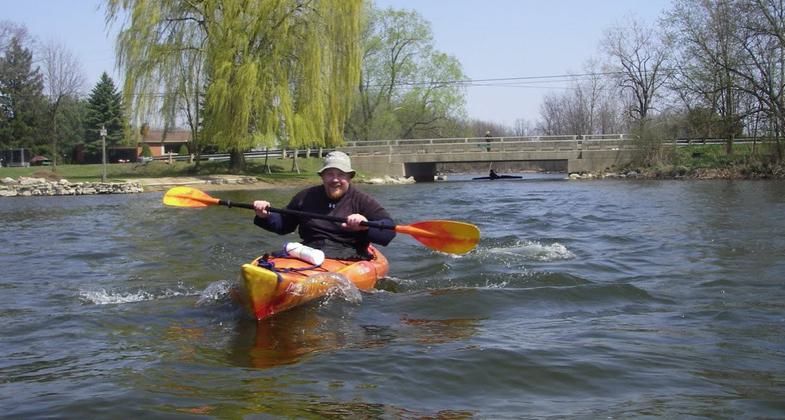
Near Tupper Lake Linden,MI. Photo by Willi Gutmann. Photo by Phil Hathaway
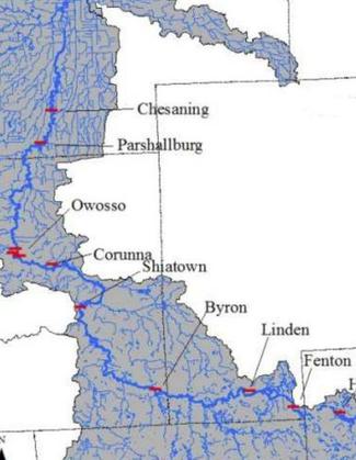
Major Cities along Shiawassee River. Photo by Willi Gutmann.

Shiawassee North of Chesaning,MI to Wildlife Refuge. Photo by Willi Gutmann.

Great OverView Shiawassee River. Photo by Willi Gutmann.

Headwaters of Shiawassee River by Davisburg Trout Pond. Photo by Willi Gutmann.
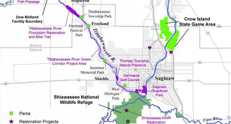
Shiawassee to Saginaw Bay.

Paddle anytime Shiawassee near Holly,MI. Photo by Willi Gutmann.

River Frontage Parks. Photo by Willi Gutmann.

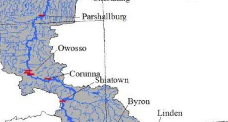
Ditch Road rapids on the Shiawassee River near Parshalburg MI. Photo by Willi Gutmann.

Headwaters Shiawassee River Springfield Township MI. Photo by Willi Gutmann.
Location: The Shiawassee River water trail is located in southeast Michigan, beginning 50 miles north of Detroit and proceeding west-northwest towards the City of Saginaw.
- States: Michigan
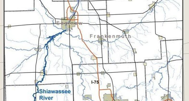
- Counties: Oakland, Genesee, Shiawassee, Saginaw
- Cities/Townships: Holly, Fenton, Linden, Byron, Vernon, Corunna, Owosso, Chesaning, and eleven townships
The Shiawassee River Water Trail is an 88-mile navigable water trail beginning in Holly, MI, and ending in Chesaning, MI. It is one of Michigan's favorite waterways with an engaging variety of riverine characteristics, 28 well-spaced public access sites with paddler amenities, relatively high water quality, and a Mid-West class smallmouth bass fishery.
The Trail is inclusive and convenient to a vast regional population that can experience a predominantly natural environment that is more often associated with the sparsely settled river systems of northern Michigan. The river is becoming recognized as a recreational asset due to the work of three non-profit organizations focused on improving water quality and community improvements along the Water Trail.
Natural features unique to the water trail include high-quality fens and forested wetlands, and scenic rural vistas. Water Trail users will experience the opportunity to view abundant wildlife including beavers, bald eagles, and the powesheik skipperling butterfly. The rare cardinal flower can also be seen growing along the banks. Conservation is primarily promoted by HeadwatersTrails, Inc. and the DeVries Nature Conservancy.
The water trail character can be described as country scenic, wooded wetland, rural residential, or trail town. This provides a diversity of paddling experiences along one water trail, offering opportunities for isolation, wildlife viewing, group paddles, or multi-modal trips. Paddling skills required are either classified as beginner or intermediate providing a great destination for family outings as well as challenge and excitement for the seasoned paddler.
The variety of experiences is due largely to the geology and glacial history of the area. The land surfaces from Holly to Byron are generally low-lying and slightly undulating till plains with a consistent series of lakes and wetlands formed as the glacier stalled and built the east-west moraine wall south of the Shiawassee River. Tributaries for the river enter mostly from the south; the watershed divide on the north side yields relatively short distances to the Flint River watershed. After Byron, the slightly undulating till plains are interspersed with rolling moraine country up to 40 feet above river level. At Shiatown meltwaters of the glacial Lake Erie flowed east to west in what geologists call a glacial spillway, now the Maple River and a mile-wide Valley west of today's course of the Shiawassee River. Sands and gravels including the streambed materials supply evidence. In Owosso, the retreating glacier and land uplift from glacier removal allowed a lower outlet to the developing Saginaw River. The Henderson to Chesaning segment enters into the former lake bed of Lake Huron. There are still sections of valley walls near Oakley and the intriguing "Kentucky holler" character of Six Mile Creek (with an abandoned coal mine too). The farmland is level with no undulations. The agricultural drains are deeply incised entry points to the River. Former sand dunes from the Lake Shore glacial period abut a few bank sections.
Recreation on the water trail includes kayak, canoeing, and paddleboarding along with motorized boats and jetskis on the impoundments in Fenton, Linden, and Byron, Lake Ponemah, and Tupper Lake. Several local and county parks are along the water trail and offer opportunities for picnicking, fishing, and connections to nonmotorized trails. The water trail features a paddle-up restaurant in Fenton, two paddle-up campgrounds, regularly scheduled group paddles, education classes, thirteen public parks, and eight trail towns offering amenities to travelers. Impoundments in Fenton, Linden, and Byron offer opportunities for beginner paddling experiences and safety classes.
The water trail features many historic towns. The Village of Holly, Fenton, Linden, Corunna, and Owosso are all along historic Native American trading routes and became river-based trading towns from the early to mid-1800s water power mills. Other historic features include Fenton's Historical Museum, Linden Historical Museum, Knagg's bridge trading post, Corunna's Historic Village, Owosso's 1223 Steam Locomotive Rail Museum, Curwood Castle, and Comstock Cabin.
The trail towns feature access to a commercial canoe livery near Byron, two outfitters in Fenton, and overnight lodging at campgrounds, bed-and-breakfasts, and hotels. Numerous restaurants and a variety of shopping experiences are also present.
Accessibility Information
There are two handicap accessible launch platforms in Linden and Corunna, Michigan. We expect two more to be installed either in 2024/2025 in Chesaning Township at Parshallburg Park and Village of Chesaning at Showboat Park.
Reviews
Willi Gutmann
Kayaking the Headwaters to the Saginaw Bay
The Shiawassee River offers something to everyone. The headwaters section has a narrow river with numerous twists/turns through wetland fens and forests. The river widens out a bit flowing through farmland areas in the middle of the State of Michigan. The northern end enters the Shiawassee Wildlife Refuge and flows into Saginaw Bay, Michigan.
Allowed Uses:
Boating, motorized Boating, human-powered SwimmingOther Activities
- Camping
- Fishing
- Heritage and history
- Hunting
- Ice skating
- Wildlife viewing / observation
Public Contact
David Lossing, ChairShiawassee River Water Trail Coalition
211 Hickory Street
Linden, MI 48451
[email protected] • (810) 869-9438
www.shiawasseewatertrail.org
More Details
- Elevation (low): --
- Elevation (high): --
- Elevation (cumulative): --
- Part of a Trail System? No
- State Designations: MI State Water Trail, Michigan Department of Natural Resources
- Surface (primary): --
- Surfaces (additional): Rock, boulders, Rock, smooth, Snow or ice, Water, calm
- Tread Width (average): 0"
- Tread Width (minimum): 0
- Running length (minimum): --
- Tread Grade (average, percent): --
- Tread Grade (maximum):
- Running length (maximum): --
- Cross-slope (average, percent): 0
- Cross-slope (maximum): --
- Running length (maximum): --
- Certified as an NRT
Oct 25, 2020