Rim Rock Trail
check with the trail manager for updated details before visiting.
Rim Rock Trail
USDA Forest Service
Backcountry Trail
- Length
0.8 miles
- Elevation Gain
--
- Route Type
Loop
(1 review)
- Length
0.8 miles - Elevation Gain
-- - Route Type
Loop
Hikers descend a rim rock escarpment to visit the historic Ox-Lot Cave. This trail also joins with Beaver Trail #006 and River to River Trail #001.
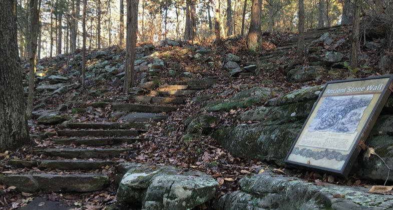
The upper trail passes through a prehistoric stone wall built by Native Americans. Photo by Donna Kridelbaugh.

2020 NRT Photo Contest Winner - Trail Facilities. Photo by Jonathan Voelz.

The upper trail is a flagstone pathway that travels along the rim of a sandstone bluff. Photo by Donna Kridelbaugh.

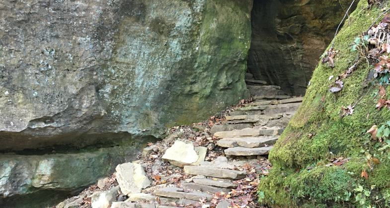
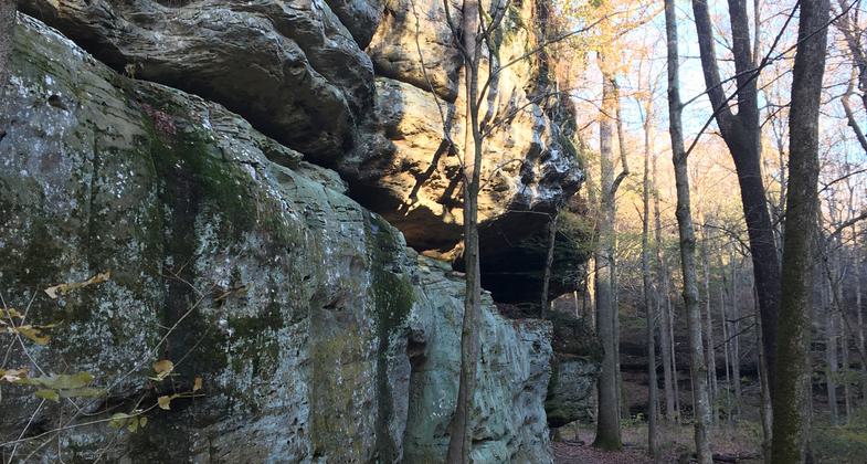
The lower trail features an ox-lot cave used by early settlers to the area. Photo by Donna Kridelbaugh.

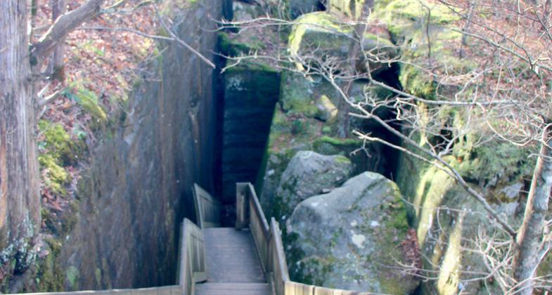
A series of rock passages leads the hiker from the upper trail to ox-lot cave. Photo by Donna Kridelbaugh.

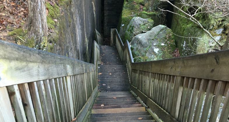
A staircase descends from the upper trail to access the lower trail and ox-lot cave. Photo by Donna Kridelbaugh.

The lower trail offers views of the sandstone bluffs from the forest floor. Photo by Donna Kridelbaugh.

Entrance to the Rim Rock Trail and Picnic Area. Photo by Donna Kridelbaugh.

Top of Rim Rock National Recreation Trail leading to Pounds Hollow in autumn. Photo by LoveThesePics.

Location: In Shawnee NF on Karbers Ridge Road between SR 1 and SR 34, approximately 23 miles south of Harrisburg, Illinois. 37 36' 8.76" N, 88 16' 41.97" W
- States: Illinois
- Counties: Gallatin
Hikers descend a rim rock escarpment to visit the historic Ox-Lot Cave. This trail also joins with Beaver Trail #006 and River to River Trail #001.
Tucked away in the rolling Shawnee Hills of southern Illinois is Rim Rock National Recreation Trail. Rim Rock Trail meanders along the edge of the bluff top, hence its name, and features vistas of a canyon below, remnants of prehistoric Native American life, and diverse habitats.
Whether you're looking for a place to picnic with your family, hike, study Native American culture or native ecosystems, or just enjoy the peaceful beauty of nature, Rim Rock National Recreation Trail and picnic area is the place for you.
One of the first features you reach is the infamous Ox-Lot Cave that besides European settlers, Native Americans were the first to use the cave, as it makes a perfect natural shelter. Standing by the cave, you will feel the cool air rising from the opening and can stop to listen to the sounds of the water trickling from the base of the bluffs. All of this takes you back to the days when early settlers used the area to keep their livestock while logging the area.
While hiking the lower trail (a dirt surface), you will stroll along the base of impressive sandstone bluffs that tower above you with a close-up view of strange honeycomb patterns in some areas and huge boulders that fell away from the bluff millions of years ago.
This trail also joins with Beaver Trail #006 and River to River Trail #001.
Accessibility Information
No text provided.
Reviews
Donna Kridelbaugh
NRT Ambassador Review
The Rim Rock Trail is a double-loop trail system composed of upper and lower trails that are open to foot traffic only. The upper trail, designated as a National Recreation Trail, is a 0.8-mile flagstone walkway that travels along the rim of an impressive sandstone bluff. The west side of this upper trail is relatively flat and passes several scenic destinations with interpretative signage, including a sandstone barren and a platform overlooking Pounds Hollow. From the platform, hikers can descend a wooden staircase and maneuver through a series of rock passages to access the lower trail and view the massive ox-lot cave/rock shelter from below. Staying on the upper trail, there are several sets of rock staircases that return the hiker back to the parking lot after passing through a prehistoric rock wall. The 0.7-mile lower trail is a natural-surface pathway that encircles the base of the sandstone bluff walls and massive boulders. Both trails are located within the Pounds Hollow Ecological Area, so camping and campfires are not allowed here. The Rim Rock Trail and Picnic Area has ample parking, a pit toilet and a large picnicking area. Additionally, one can access the nearby Pounds Hollow Recreation Area with a short drive or on foot from the Pounds Hollow Lake Trail that intersects with the lower portion of the Rim Rock Trail. Overall, the trails were in excellent condition and offered a secluded retreat. This is definitely a hidden gem within the Shawnee National Forest. Please remember to leave no trace while out on the trail.
Allowed Uses:
Dogs, on leash Hiking/WalkingOther Activities
- Wildlife viewing / observation
Public Contact
Shawnee National Forest50 Hwy. 145 S.
Harrisburg, IL 62946
(618) 253-7114
www.fs.usda.gov/main/shawnee/home
Contact the trail manager for current maps and visiting details.
More Details
- Elevation (low): 321
- Elevation (high): 660
- Elevation (cumulative): --
- Part of a Trail System? No
- Surface (primary): Paved
- Surfaces (additional): Rock, crushed, Rock, smooth
- Tread Width (average): 36"
- Tread Width (minimum): --
- Running length (minimum): --
- Tread Grade (average, percent): 8
- Tread Grade (maximum): 35
- Running length (maximum): --
- Cross-slope (average, percent): --
- Cross-slope (maximum): --
- Running length (maximum): --
- Certified as an NRT
Dec 12, 1979