Red River Gorge
This information is a public record of the 1978 NRT application and may be out of date if it has not been updated by a trail manager --
check with the trail manager for updated details before visiting.
check with the trail manager for updated details before visiting.
Red River Gorge
USDA Forest Service
Backcountry Trail
- Length
34 miles
- Elevation Gain
--
- Route Type
out & back
- Length
34 miles - Elevation Gain
-- - Route Type
out & back
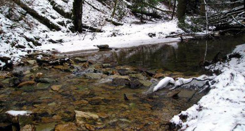
The rock ford where the Buck Trail crosses Chimney Top Creek in the Red River Gorge National Recreation Trail system.
Location: 15 miles east of Stanton KY., in Daniel Boone National Forest just north of the Combs Mountain Parkway.
- States: Kentucky
- Counties: Powell, Wolfe, Menifee
This trail system is located in the Red River Gorge Natural Landmark and Geological Area. Unique stone arches, rock shelters, Clifty Wilderness, Red River National Wild & Scenic River, and miles of rugged cliff lines can be found in this area. The "Gorge" is nationally recognized as a special place for its archeological sites and has one of the highest concentrations of petroglyphs in the eastern United States.
Accessibility Information
No text provided.
Allowed Uses:
Dogs, on leash Hiking/WalkingOther Activities
- Camping
- Fishing
Public Contact
Tim ElingUS Forest Service
Cumberland Ranger District
Stanton, KY 40380
[email protected] • (606) 663-2852
www.fs.usda.gov/dbnf
Contact the trail manager for current maps and visiting details.
More Details
- Elevation (low): 800
- Elevation (high): 1200
- Elevation (cumulative): --
- Part of a Trail System? No
- Surface (primary): Soil
- Surfaces (additional): Soil
- Tread Width (average): 30"
- Tread Width (minimum): --
- Running length (minimum): --
- Tread Grade (average, percent): 10
- Tread Grade (maximum): 25
- Running length (maximum): --
- Cross-slope (average, percent): --
- Cross-slope (maximum): --
- Running length (maximum): --
- Certified as an NRT
Nov 16, 1978