Ohio River Way
check with the trail manager for updated details before visiting.
Ohio River Way
Nonprofit
National Water Trail
- Length
308 miles
- Elevation Gain
132
- Route Type
out & back
- Length
308 miles - Elevation Gain
132 - Route Type
out & back
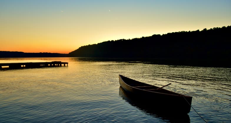
The Ohio River Way is a 308-mile water trail spanning sections of Indiana, Kentucky, and Ohio. This route connects Appalachian wilderness to small river towns and dynamic metropolitan centers. Beyond its natural beauty, the trail is steeped in cultural heritage—from Lewis and Clark's expedition to the Underground Railroad and the flatboats and steamboats that helped shape the region. The fact the Ohio River is a big river with numerous tributaries to explore makes the Ohio River Way stand out as a water trail. The river's width varies from a quarter-mile to a mile, with an average depth of 26 feet. The trail is loved by adventure-seekers ranging from folks on half-day paddles to thru-paddling enthusiasts who camp along the way.


Location: On the Ohio River from Ashland to West Point, KY. The trail is 308 miles and bordered by three states, Kentucky to the South and Ohio and Indiana to the North.
- States: Indiana, Kentucky, Ohio
- Counties: Adams, Boone, Boyd, Bracken, Brown, Campbell, Carroll, Clark, Clermont, Dearborn, Floyd, Gallatin, Greenup, Hamilton, Hardin, Harrison, Jefferson, Kenton, Lawrence, Lewis, Mason, Meade, Ohio, Oldham, Pendleton, Scioto, Switzerland, Trimble
- Cities/Townships: Cities - Ohio: Ironton, Rome, Manchester, Aberdeen, Ripley, Higginsport, Chilo, Moscow, New Richmond, Anderson Township, Cincinnati, North Bend Cities - Indiana: Lawrenceburg, Aurora, Rising Sun, Florence, Vevay, Madison, Hanover, Utica, Jeffersonville, Clarksville, New Albany Cities - Kentucky: Ashland, Vanceburg, Maysville, Augusta, California, Silver Grove, Ft. Thomas, Dayton, Bellevue, Newport, Covington, Ludlow, Bromley, Rabbit Hash, Petersburg, Warsaw, Carrollton, Westport, Louisville, West Point Townships - Ohio: Perry, Upper, Hamilton, Green, Porter, Washington, Nile, Green, Monroe, Manchester, Sprigg, Huntington, Union, Pleasant, Lewis, Franklin, Washington, Monroe, Ohio, Pierce, Anderson, Delhi, Miami, and Whitewater Townships - Indiana: Lawrenceburg, Hogan, Center, Washington, Randolph, Posey, York, Jefferson, Craig, Milton, Madison, Hanover, Saluda, Bethlehem, Owen, Charlestown, Utica, Jeffersonville, New Albany, Franklin, Posey, and Taylor. Townships - Kentucky: Kentucky does not have township governments.
The Ohio River Way is a 308-mile water trail winding alongside Kentucky, Ohio, and Indiana. For paddlers, the scale of the river is immediately striking. With widths reaching up to a mile, the Ohio River presents a vast and varied landscape. In some sections, you’ll feel a sense of seclusion as the water meanders between forested bluffs and ancient mountains. In other portions, paddlers are treated to the towering urban skylines of Louisville and Cincinnati. That’s not to mention the humbling perspective of going through the four locks on the Ohio River Way, designed to accommodate massive 15-barge tows.
In addition to its diverse landscapes, the Ohio River Way is known for its variety of adventures. The river is loved by everyone from those seeking a serene afternoon paddle – perhaps with a fishing pole in hand – to those embarking on multi-day wilderness excursions. With the river’s average depth of 26 feet and varying widths, conditions can shift quickly from calm, glassy water to more challenging waves of up to three feet. Thick fog can blanket the river in the morning, and paddlers must be watchful of the recreational and commercial boat traffic.
This water trail is more than just a paddling route. It’s a journey through the cultural and historical heart of the region. The Ohio River has long been a lifeline, starting with the many Indigenous peoples who lived along the river. Indigenous archaeological sites are accessible along the Ohio River Way, such as the Tremper Mound and Earthworks built by the Hopewell culture and the Portsmouth Earthworks made by the Adena and Ohio Hopewell cultures. As European explorers and colonists arrived, the river was home to flatboats and, later, steamboats, facilitating industrialization and westward expansion. The river was also a key landmark in the Underground Railroad, serving as a boundary between slave states and free. As you paddle along the Ohio River Way, these stories echo in the landscapes, towns, and landmarks you pass.
For those planning a trip, the Ohio River Way has resources to ensure a more safe and enjoyable experience. The Ohio River Way’s award-winning Interactive Map offers 28 layers of detailed information on amenities, access points, and navigation, including live barge traffic. Additionally, the Ohio River Way has segment guides published on its website that provide more detailed narratives as you plan your trip.
Of course, safety is always the top priority. There are special considerations on the Ohio River since it’s a multi-use waterway that supports both recreational and commercial traffic. The Ohio River Way has an On-Water Safety Guide developed in collaboration with key agencies like the U.S. Coast Guard and the U.S. Army Corps of Engineers. Additionally, there are two safety videos supplementing this guide, providing visual safety instructions and information on how to go through the locks. It’s important that paddlers always make a plan and check conditions, and the Ohio River Way’s safety page includes links to information about weather conditions, water quality, and other factors that might affect a paddler’s trip.
The Ohio River Way is home to a number of paddling events. The Ohio River Paddlefest in Cincinnati, the largest paddling celebration in the U.S., draws over 2,000 participants annually, with canoeists, kayakers, and paddleboarders converging on the river for a day of fun and camaraderie. There are plenty more paddling events too: the M2M paddle between Manchester, OH, and Maysville, KY; Portsmouth’s P-Town Float; and Hike, Bike, and Paddles in Carrollton and Louisville, KY. While unconventional, there’s the annual Cardboard Boat Race in New Richmond, OH, too! Other events go beyond paddling: Fishing tournaments, regattas, and riverfront festivals showcase the Ohio River’s ability to connect locals and visitors to vibrant river communities and the region’s natural beauty.
The Ohio River Way itself began with the efforts of a dedicated group of volunteer paddling enthusiasts. The idea came about during a 30-hour trip from Cincinnati to Louisville, paddling by starlight, as these volunteers began envisioning how the Ohio River Way could make this stretch of the river an accessible water trail. Since then, the commitment of these volunteers has grown into a coalition of communities and organizations, all united in helping people find adventure along the Ohio River Way. Today, this collaborative effort ensures that the trail remains a vibrant and sustainable resource for paddlers and river communities alike.
From its wilderness stretches to its bustling urban ports, the Ohio River Way invites paddlers of all skill levels to engage deeply with the history and landscapes that define the Ohio River. Whether you’re an experienced paddler seeking a multi-day adventure or a beginner looking for an afternoon on the water, the Ohio River Way offers an unforgettable experience on a big river. The Ohio River Way’s combination of majestic beauty, cultural significance, and river town hospitality makes it a truly unique water trail.
Accessibility Information
Of the Ohio River Way’s 75 access points, most are concrete boat ramps. There is only one access point along the Ohio River Way that currently has an ADA-accessible canoe and kayak launch: the Manchester Kinfolk Landing at river mile 397.2. To learn more about how ADA-accessible launches work, visit boardsafedocks.com/accessible-kayak-launch/. The Ohio River Way is working to expand our accessibility. In partnership with the Ohio Department of Natural Resources, Rep. Brad Wenstrup (OH-02) submitted a $1.75 million Community Project Funding on our behalf to build 17 ADA-accessible kayak and canoe docks and 40 informational kiosks from Meigs County to Hamilton County in Ohio. If successful, this 233-mile stretch of the Ohio River would become one of the most accessible stretches of major rivers in the U.S. Titled the “Ohio River Way Access for ALL Project,” our request passed out of the U.S. House Appropriations Committee on July 10, 2024.
Allowed Uses:
Boating, motorized Boating, human-powered Swimming Dogs, off leashOther Activities
- Camping
- Fishing
- Heritage and history
- Hunting
- Wildlife viewing / observation
Public Contact
Forest Clevenger, Executive DirectorOhio River Way
P.O. Box 812
Cincinnati, OH 45201
[email protected]
More Details
- Elevation (low): 383
- Elevation (high): 515
- Elevation (cumulative): 132
- Part of a Trail System? No
- National Designations: US Federal Waterway, Lewis and Clark National Historic Trail, Ohio River Islands National Wildlife Refuge
- State Designations: Ohio River Scenic Byway
- Surface (primary): Water, slow moving
- Surfaces (additional): Grass or Vegetation, Rock, crushed, Sand, Water, slow moving
- Tread Width (average): --"
- Tread Width (minimum): --
- Running length (minimum): --
- Tread Grade (average, percent): --
- Tread Grade (maximum):
- Running length (maximum): --
- Cross-slope (average, percent): --
- Cross-slope (maximum): --
- Running length (maximum): --
- Certified as an NRT
Jun 8, 2025