Moab Slickrock Bike Trail
check with the trail manager for updated details before visiting.
Moab Slickrock Bike Trail
Bureau of Land Management
Backcountry Trail
- Length
12.1 miles
- Elevation Gain
--
- Route Type
out & back
- Length
12.1 miles - Elevation Gain
-- - Route Type
out & back
The Moab Slickrock Bike Trail consists of a main trail approximately 10.1 miles long (counting the 2.5 miles section between the trailhead and the loop portion of the main trail only once) and a practice loop approximately 2.0 miles long (not including 0.3 miles of the loop counted as part of the main trail).
Location: The trail is located between Moab Valley, the gorge of the Colorado River, and the Negro Bill Canyon system.
- States: Utah
The Moab Slickrock Bike Trail consists of a main trail approximately 10.1 miles long (counting the 2.5 miles section between the trailhead and the loop portion of the main trail only once) and a practice loop approximately 2.0 miles long (not including 0.3 miles of the loop counted as part of the main trail).
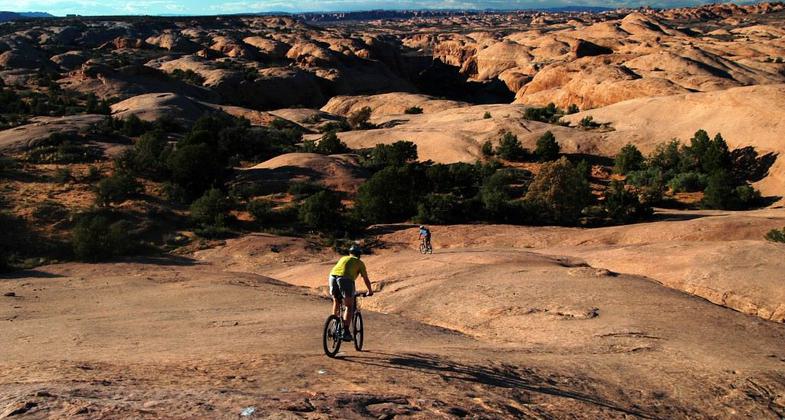
The Moab Slickrock Bike Trail is entirely located on exposed pale orange Navajo sandstone, referred to locally as "slickrock" except for approximately 200 total yards in several segments that pass through pockets of sand. Most of the area is barren rock. Vegetation along the route is limited to isolated pockets of pinion and juniper trees with yucca, Indian rice grass, and cryptobiotic soil crusts found in small valleys, open"parks", and former"potholes" now filled in by sandy soils.
The area through which the bike trail passes is composed of eroded sandstone fins, domes, and rock outcrops. The trail route is marked by white dashes painted upon the sandstone. The route goes up and down sandstone domes and fins, near the edges of deep canyons, and along the top of the cliff above the Colorado River. Guidebooks describe elevation changes along the trail as"constant'.
Initially established in 1969 as a trail for use by small motorcycles, the Moab Slickrock Bike Trail is now widely considered to be the most well-known mountain bike trail in the world. Moab is described as the"Mecca" of mountain biking because of the Slickrock Trail. The trail continues to be open to both motorcycle and mountain bike use. The Navajo sandstone provides excellent traction for rubber-tired vehicles. The tremendous variety of terrain, riding challenges, and scenery along the trail have made it a national and international destination. Non-motorized rides on the main trail take from two to five hours. The technical difficulty of the trail, in combination with the stamina needed for riding, attracts expert riders.
The Moab Slickrock Bike Trail is the focal point of the Sand Flats Recreation Area. The recreation area is jointly managed by the Bureau of Land Management's Moab Field Office and Grand County's Community Sand Flats Team through a cooperative agreement. The recreation area is Moab's backyard and is used by visitors and residents with over 80,000 visits annually.
The founding of the Moab Slickrock Bike Trail by Dick Wilson, a local newspaper writer, and its evolution from a sleepy motorcycle trail to a famous mountain bike trail would make an interesting story.
Accessibility Information
No text provided.
Allowed Uses:
BicyclingPublic Contact
Moab Field Office82 East Dogwood
Moab, UT 84532
Contact the trail manager for current maps and visiting details.
More Details
- Elevation (low): --
- Elevation (high): --
- Elevation (cumulative): --
- Part of a Trail System? No
- Surface (primary): --
- Surfaces (additional): --
- Tread Width (average): 0"
- Tread Width (minimum): --
- Running length (minimum): --
- Tread Grade (average, percent): --
- Tread Grade (maximum):
- Running length (maximum): --
- Cross-slope (average, percent): --
- Cross-slope (maximum): --
- Running length (maximum): --
- Certified as an NRT
Sep 19, 1992