Mississippi River Water Trail
check with the trail manager for updated details before visiting.
Mississippi River Water Trail
U.S. Corps of Engineers
National Water Trail
- Length
121 miles
- Elevation Gain
--
- Route Type
out & back
- Length
121 miles - Elevation Gain
-- - Route Type
out & back
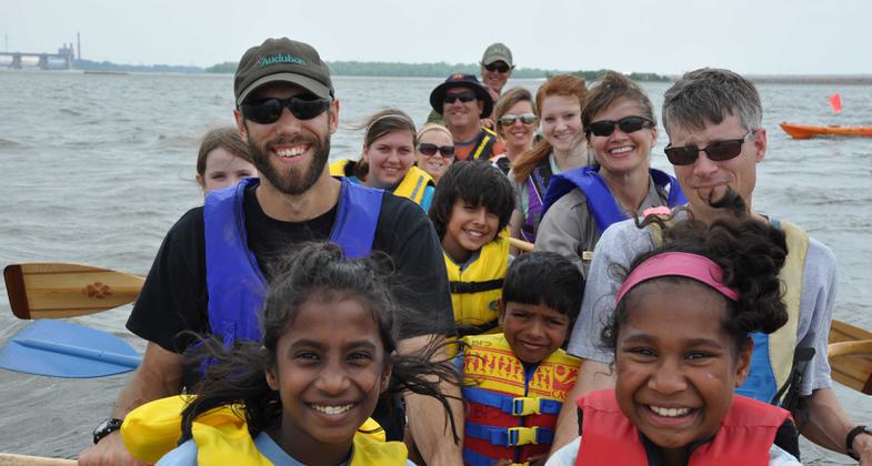
The Mississippi River Water Trail (MRWT) passes through the heart of North America and is deeply rooted in natural scenic beauty, Native American heritage and cultural history. Known as Father of the Waters, the Mississippi River provides an adventure like no other for visitors. The trail encourages people to experience their Mississippi River from a boat, much like Huck Finn and Tom Sawyer, and offers days use areas, primitive camping, wildlife viewing, special event and programming and numerous other educational opportunities.


Location: Saverton, Missouri at mile marker 301, downstream side of Lock and Dam 22 to St. Louis, Missouri Riverfront (Arch) at mile marker 180
- States: Illinois, Missouri
- Counties: Calhoun, Jersey, Madison, Pike, St. Clair, Lincoln, Ralls, St. Charles, St. Louis
- Cities/Townships: Louisiana, Clarksville, Winfield, St. Louis, MO/Hamburg, Grafton, Elsah, Alton, IL
The Mississippi River Water Trail (MRWT) passes through the heart of North America and is deeply rooted in natural scenic beauty, Native American heritage, and cultural history. Known as Father of the Waters, the Mississippi River provides an adventure like no other for visitors. The trail encourages people to experience the Mississippi River from a boat, much like Huck Finn and Tom Sawyer and offers day-use areas, primitive camping, wildlife viewing, special event and programming, and numerous other educational opportunities.
The US Army Corps of Engineers, Rivers Project Office is home to the Mississippi River Water Trail. The Rivers Project provides recreation, environmental stewardship, and interpretive services and outreach for communities along 300 miles of the Mississippi River and 80 miles of the Lower Illinois River. The project consists of 50,000 acres of public land and 67,000 acres of water which lie in 2 states, 13 counties, and 7 congressional districts.
The development of the Mississippi River Water trail is an innovative approach to providing high-quality, low-cost outdoor recreation while encouraging low-impact use of public lands and promoting stewardship of natural resources along the river. The water trail promotes the Mississippi River in a safe and environmentally friendly way by educating the public on leave no trace concepts and promoting safety on the river. Local communities have engaged the Corps and become valuable partners in this effort to showcase the River and provide safe, low-cost access.
In 2005 the Rivers Project Office began the development of the Mississippi River Water Trail. In 2007 a cooperative agreement was signed between the Corps of Engineers, the American Canoe Association, and the Mississippi River Water Trail Association to partner on the development and implementation of the trail.
The Mississippi Water Trail acts as a conduit for telling the Corp's story and fostering appreciation and support for the river, its habitats, and its importance as a transportation corridor and economic engine for our nation. Recreation “ The water trail provides high quality, low cost (O&M cost) outdoor recreation and encourages people to get outside. Environmental Stewardship “ The water trail allows people to intimately interact with nature and learn how to become good stewards of public lands. Navigation “ The water trail exposes people to our navigation mission and encourages safe river use and the river as a shared resource. Paddlers are exposed to navigation (traffic), locks and dams, and the need for river training structures and the 9-foot navigation channel. Education & Interpretation “ The water trail engages a new group of users and through outreach, we are able to interpret our missions and educate people about the river while encouraging good stewardship of public lands. It also provides the opportunity to encourage people to get outside and get active.
The water trail allows us to reconnect Americans, especially children, to America's rivers and waterways by creating corridors and connectivity across outdoor spaces. Paddling provides the vehicle for getting people to/on the river so they can reconnect and gain respect for the river. The water trail serves as a ribbon connecting public lands along the river and promoting the public's use of these lands. It helps foster respect for water and the importance of the Mississippi River to our country and the world. The water trail development has brought Federal and State landowners together with river communities and reinforces the collaboration for conserving public lands for public use.
The most important part of the trail development was working with the paddling community to develop a trail that they could take ownership of and support. During the planning effort, strategic decisions were made to allow for further expansion of the trail within other reaches of the river with a goal of one day connecting all of the reaches of the river into one large water trail system. The numbering system, maps, and video were developed and formatted so they could be shared with other agencies and organizations and used from the Headwaters to the Gulf to make the trail seamless. To make each segment of the trail unique and identifiable by location segment names were given to the pools or reaches. Pool 24/Pike's Passage, Pool 25/Pinnacle Pass, and Pool 26/27 Bluffs Trail were all named using either significant historical or environmental features of each geographic location.
Learn more about the the Mississippi River Water Trail at MississippiRiverWaterTrail.org. We have a variety of events throughout the year including a Paddle Festival, the Firecracker Race, Mississippi Meanderings, Sunset paddles, and skill clinics offered to teach paddlers how to safely paddle on big rivers like the Mississippi.
Accessibility Information
No text provided.
Allowed Uses:
Boating, motorized Boating, human-powered SwimmingOther Activities
- Camping
- Fishing
- Heritage and history
- Wildlife viewing / observation
Public Contact
Chris GarciaUS Army Corps of Engineers
Rivers Project Office
West Alton, MO 63386
[email protected] • (636) 899-2600
More Details
- Elevation (low): --
- Elevation (high): --
- Elevation (cumulative): --
- Part of a Trail System? No
- National Designations: N/A
- State Designations: N/A
- Surface (primary): --
- Surfaces (additional): Water, calm
- Tread Width (average): 0"
- Tread Width (minimum): 0
- Running length (minimum): --
- Tread Grade (average, percent): --
- Tread Grade (maximum):
- Running length (maximum): --
- Cross-slope (average, percent): 0
- Cross-slope (maximum): --
- Running length (maximum): --
- Certified as an NRT
Jul 11, 2012