Historic Railroad Trail
check with the trail manager for updated details before visiting.
Historic Railroad Trail
National Park Service
Backcountry Trail
Rail Trail
Urban Trail
- Length
3.74 miles
- Elevation Gain
--
- Route Type
out & back
- Length
3.74 miles - Elevation Gain
-- - Route Type
out & back
The Historic Railroad Trail is a multi-use trail that originates at a developed trailhead just north of the Alan Bible Visitor Center within the Lake Mead National Recreation Area and terminates at Historic Hoover Dam.
2023 Photo Contest Winner: Historic Features. Photo by Robert Edward

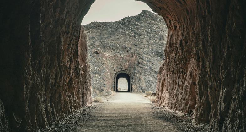
Historic Railroad Trail, tunnel, and Lake Mead

Trailhead displays near the Alan Bible Visitor Center at Lake Mead. Photo by Sue Crowe.

Interpretive sign at trailhead. Photo by Sue Crowe.

Trail marker showing NRT logo signage at Boulder City trailhead. Photo by Sue Crowe.

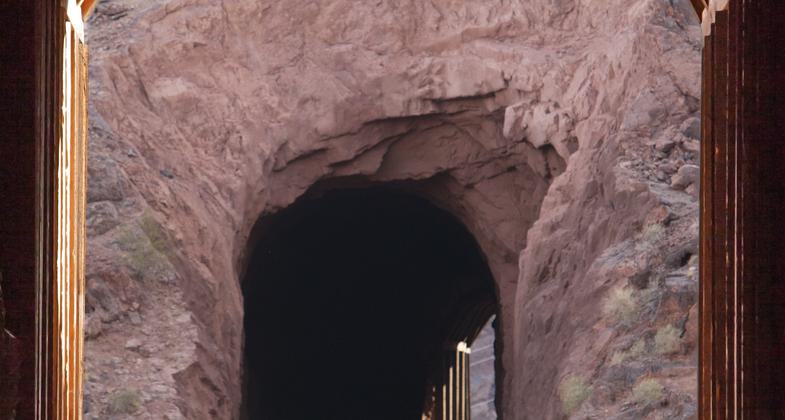
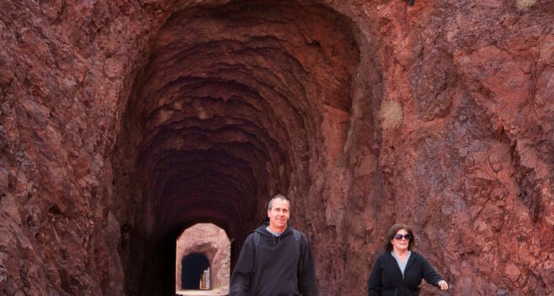
Visitor exits in a glow of light at the Historic Railroad Trail, Lake Mead NRA. Photo by Andrew Cattoir.

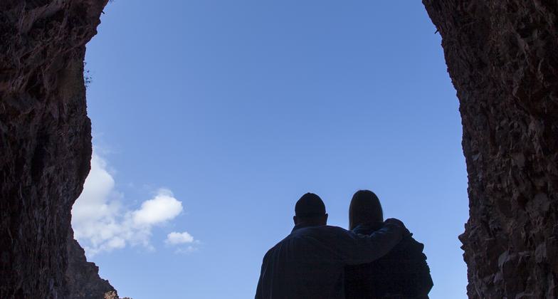
A couple pauses to enjoy a view of Lake Mead from the Historic Railroad Trail, Lake Mead NRA. Photo by Andrew Cattoir.

Visitors entering one of five tunnels at Historic Railroad Trail, Lake Mead NRA. Photo by Andrew Cattoir.

Visitors enjoying the "dog friendly" Historic Railroad Trail at Lake Mead NRA. Photo by Andrew Cattoir.

Historic Railroad Trail and tunnel.
Location: The Historic Railroad Trail is located near Boulder City, Nevada on federal lands within the National Park Service's Lake Mead National Recreation Area and the Hoover Dam Security Area under the jurisdiction of the Bureau of Reclamation.
- States: Nevada
- Counties: Clark
- Cities/Townships: Located close to the City of Boulder City, NV
The Historic Railroad Trail is located on federal land within the National Park Service's (NPS) Lake Mead National Recreation Area (NRA) and the Bureau of Reclamation's (Reclamation) Hoover Dam Security Area. The trail originates at a developed trailhead just north of the NPS's Alan Bible Visitor Center and terminates at Reclamation's Historic Hoover Dam.
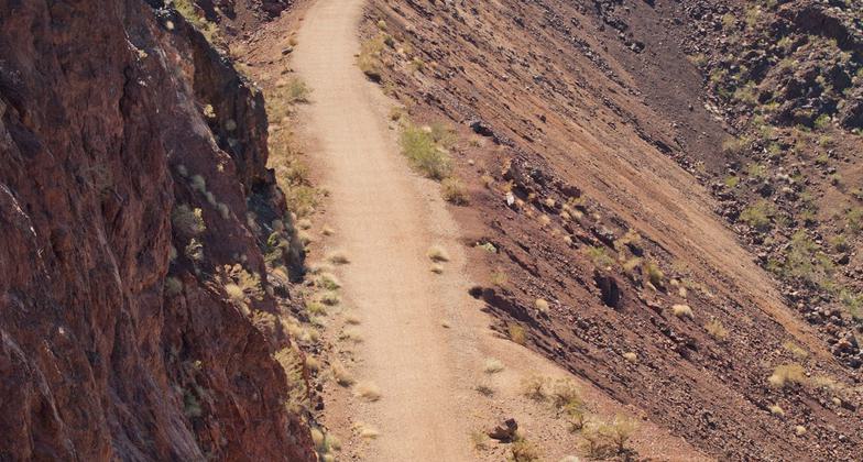
Primary access to the trail is from the trailhead near the visitor center and the parking garage at Hoover Dam. The main trail is 3.5 miles long and is considered a multi-use trail that is used primarily by hikers, joggers, and bicyclists, as well as for special events such as organized marathons. The trail is considered a relatively easy hike with an average grade of 4 percent; however, trail users should be careful when using the trail during the summer months when temperatures can reach over 100 degrees. There is also a 0.24 loop trail near Hoover Dam that has a 13 percent grade; a short undeveloped spur trail that is 0.30 miles long leading from the Hoover Dam Lodge/Casino (aka Hacienda Hotel/Casino) to the main trail; and a short concrete trail that leads from the Alan Bible Visitor to the trailhead. There are five tunnels that trail users must pass through that are approximately 25' wide, 30' high, and 300' long. There are 22 interpretive panels along the trail that provide educational information about various topics such as the 30-mile government railroad complex, desert wildlife, mountain ranges and islands within the viewshed, construction, and repair of tunnels, features of the power plant, and the hard times that were experienced by workers at Hoover Dam's Ragtown construction camp.
The original railroad grade that the trail now occupies was constructed in a remote and rugged setting of the Black Mountains. The trail offers visitors outstanding scenic views of Lake Mead, Boulder Basin, Fortification Hill, and the Virgin Mountain range some 85 miles away. Trail users can view deep ravines and massive rugged and crystalline rock formations that are relatively resistant to erosion. Trail users can view typical Mohave Desert vegetation dominated by desert shrubs and a variety of wildlife species such as desert bighorn sheep, desert tortoise, peregrine falcon, and various lizard, snake, and bat species.
Clark County supports all trail development in the county and advocates physical activities that support healthy lifestyles and communities. The county provides information on the many trails including the Historic Railroad Trail. Hiking the trail provides users with the opportunity to bond with family and friends while participating in a physical activity that can reduce stress levels and enhance an individual well being. For public safety purposes, water stations are located at Reclamation's parking garage, a switchyard near a drop-off and pick-up site, and on the Hoover Dam side of Tunnel 5. There are also emergency call boxes located at the water station near Tunnel 5, Reclamation's parking garage, and near the junction of the main trail and the loop trail.
The nationally and historically significant trail is within the first nationally designated NRA and provides outstanding scenic views of Lake Mead, the largest manmade lake in the United States. The trail is also within lands adjacent to Hoover Dam, considered a national icon and historical treasure. The dam and associated features are historically significant enough that the surrounding area has been designated as a National Historic Landmark. Once at the dam, trail users also have the opportunity to view the Mike O'Callaghan-Pat Tillman Memorial Bridge which is located downstream of the dam and 900' above the Colorado River. The bridge is the second-highest span bridge in the United States and sits on the highest precast segmented columns in the world. The bridge is the first concrete-steel composite arch bridge built in the United States and the widest concrete arch in the Western Hemisphere.
The trail lies on the original railroad grade that was professionally designed and constructed to facilitate the completion of Hoover Dam. In 1931, Six Companies, Inc., a consortium of six major western firms, was awarded the government contract to construct Hoover Dam, as well as approximately 30 miles of railroad connecting Boulder City with all the facilities needed to construct the dam (e.g., cement mixing plants, quarry pit, and gravel sorting plant). The Historic Railroad Trail segment of the railroad complex moved equipment and workers from Boulder City, Nevada to the dam construction site. Five tunnels were constructed to accommodate the oversized equipment that was used to construct Hoover Dam. The rail line was, for the most part, abandoned after the construction of Hoover Dam in 1935; however, it was used sporadically until 1961 when the last generator was hauled over its rails and installed at the power plant. The tracks were dismantled in 1962 and sold for scrap. While the railroad grade has been in existence for over 75 years, the trail has only been established since 1992 and the connection to Hoover Dam was not opened to the public until 2007. The trail was not formally completed until 2010 with the completion of the Mike O'Callaghan-Pat Tillman Memorial Bridge. The overall railroad trail alignment has been determined to be eligible for listing on the National Register of Historic Places through consensus amongst the Nevada State Historic Preservation Office, NPS, and Reclamation. A nomination form has been prepared but has not yet been submitted to the Keeper of the National Register for official listing. Although the trail has not been officially listed on the National Register, it must be treated as if it has been listed. The trail was the first Rails-to-Trails project recognized by the State of Nevada in the April 2005 Rail to Trails Magazine.
The trail is part of a large connecting trail system that connects Lake Mead, Hoover Dam, Boulder City, Henderson, and the rest of the Las Vegas Valley. The many trails provide levels of difficulty that appeal to all users. The connecting trails accommodate a variety of users such as hikers, joggers, road cyclists, mountain bikers, and equestrians. The River Mountains Loop Trail (RMLT) is a 35-mile multi-use trail that circles the River Mountains north of Boulder City. In 2000, the trail was designated as a Community Millennium Trail by the White House. In 2010, the RMLT was designated as a National Recreation Trail and recognized as part of America's national system of trails. Bootleg Canyon Mountain Bike Park consists of a network of 36 miles of interconnecting world-class mountain bike trails. In September 2001, Bootleg Canyon was named an "EPIC Trail System" by the International Mountain Biking Association. This makes Bootleg Canyon only one of 18 trails in the world with this designation. Boulder City has a series of existing biking, hiking, and jogging travel ways or paths located throughout the city. Trail users can access the Bootleg Canyon system of trails, RMLT, and Historic Railroad Trail via the city's bike paths.
The NPS and Reclamation have a long and successful managing partnership for lands within the NRA and Reclamation's Security Area. That partnership includes maintenance of the Historic Railroad Trail, cultural and natural resources, and adjacent lands using NPS and Reclamation maintenance staff including removal of debris, repair of stormwater damage, grading and compaction of trail surface, and upkeep of the many trail amenities. Both agencies will continue to issue special use permits for the use of the trail for organized events; follow the agreed-upon terms and conditions of the Trail Concept Plan established amongst NPS, Reclamation, River Mountains Loop Trail Partnership, and Outside Las Vegas Foundation®; continue to solicit and use volunteer labor and the Conservation Corp crews to assist in maintaining the trails in good condition; work to make the trail accessible to persons with disabilities; use up-to-date design concepts and principles as well as best management practices when operating, maintaining, and/or rehabilitating the trail; and follow the overall management strategies outlined in Reclamation's 2011 Hoover Dam Recreation Master Plan and the 2005 NPS's Lake Mead National Recreation Area Lake Management Plan. The NPS will continue to conduct interpretive walks as part of their interpretive program. Both agencies will continue to monitor trail conditions and make needed changes that will protect the surrounding landscape and the health and safety of the visiting public. Currently, the Federal Highway Administration (FHWA) conducts routine inspections of the five tunnels and recommends needed structural and public safety improvements that are then contracted by the NPS. Both agencies will continue to seek funding from a variety of sources such as appropriated funds obtained from Congress, grant funds from the Southern Nevada Public Lands Management Act, FHWA discretionary funds as part of America's Byways® program, Federal Lands Access Program grant funds available to Federal agencies, NPS park entrance fees, and funds obtained through private donations to help offset trail expenses.
Accessibility Information
No text provided.
Allowed Uses:
Bicycling Dogs, on leash Hiking/WalkingOther Activities
- Heritage and history
- Wildlife viewing / observation
Public Contact
Bruce NyhuisDepartment of the Interior, National Park Service
601 Nevada Highway
Boulder City, NV 89005
[email protected] • (702) 293-8966
Contact the trail manager for current maps and visiting details.
More Details
- Elevation (low): 1409
- Elevation (high): 1595
- Elevation (cumulative): --
- Part of a Trail System? No
- National Designations: Eligible for listing on the National Register of Historic Places and Portion of the trail is within the Hoover Dam National Hist
- State Designations: Recognized by Nevada as Rails-to-Trail, 2005
- Surface (primary): Rock, crushed
- Surfaces (additional): Paved, Rock, crushed, Soil, Soil with stabilizer
- Tread Width (average): 108"
- Tread Width (minimum): 96
- Running length (minimum): --
- Tread Grade (average, percent): 4
- Tread Grade (maximum): 13
- Running length (maximum): --
- Cross-slope (average, percent): 2
- Cross-slope (maximum): --
- Running length (maximum): --
- Certified as an NRT
Jun 3, 2015