Hillman Heritage Trail
check with the trail manager for updated details before visiting.
Hillman Heritage Trail
USDA Forest Service
Backcountry Trail
- Length
5.47 miles
- Elevation Gain
--
- Route Type
Loop
(1 review)
- Length
5.47 miles - Elevation Gain
-- - Route Type
Loop
The trail winds along the ridge tops provide the hiker with a scenic view of Kentucky Lake, various forest habitats, and many species of wildlife including deer wild turkey, red-tailed hawks, bald eagles, and bobcats. The oak-hickory hardwood forest also contains dogwood, rebud trees, and spring flowers.
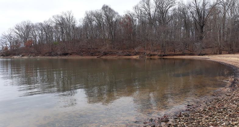
Photo by Donna Kridelbaugh & John Stone.

Photo by Donna Kridelbaugh & John Stone.

Photo by Donna Kridelbaugh & John Stone.

Photo by Donna Kridelbaugh & John Stone.

Photo by Donna Kridelbaugh & John Stone.

Photo by Donna Kridelbaugh & John Stone.

Photo by Donna Kridelbaugh & John Stone.

Photo by Donna Kridelbaugh & John Stone.

Photo by Donna Kridelbaugh & John Stone.
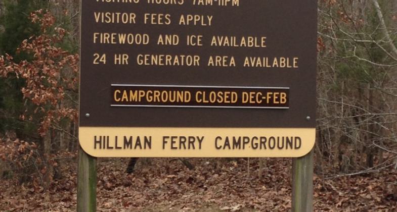
Location: Access from Hillman Ferry Campground on W shoreline of Land Between the Lakes.
- States: Kentucky
- Counties: Lyon
The 5.47 miles of trails within the Hillman Ferry Campground Woods are listed as a Heritage National Recreation Trail. The trail system often follows old historic roads used by the former Star Lime Works community which was the site of a thriving lime industry that began sometime before the Civil War. The community survived through changes in lime works ownership and many economic fluctuations in the production of lime and limestone until it was disbanded sometime after 1945 due to the construction of the Kentucky Lake Reservoir. Star Lime Works is being recorded as a historic district and the remaining cultural features, landscape, and history are just beginning to be portrayed through interpretive stops along the trail. Current interpretive stops are along Bohanon Loop and Vogle Loop.
Note: there is no backcountry camping allowed off the trail. Camping is available in the campground at the trailhead.
Accessibility Information
No text provided.
Reviews
Donna Kridelbaugh
NRT Ambassador Review
The Hillman Heritage Trail is located on the northern end of the Land Between the Lakes National Recreation Area. It is an approximately 5.5-mile trail system composed of multiple loops and connector trails. We visited the area during the time the campground was closed in the winter but were still able to park at a visitor parking lot just before the main campground gate and walk a short distance in. The main trailhead is located directly behind the Hillman Ferry Campground entrance. From the connector at the main trailhead, we created a double loop trail following the Bohanon and Vogle Loops for a total distance of 3 miles. There are interpretative signs along these two loops that travel by remnants of a limestone quarry and local community that once thrived in this area before the Kentucky Lake Reservoir was created. Vogle Loop provides panoramic views of the lake at a private beach area with strikingly unique rock formations. Unfortunately, these formations had been marked up by graffiti, which marred the natural landscape. Overall, this was an easy hike with many historic and scenic points along the route. Please remember to leave no trace when visiting national recreation trails so that everyone can enjoy the beauty of these places.
Allowed Uses:
Bicycling Swimming Dogs, on leash Hiking/WalkingOther Activities
- Camping
- Fishing
- Wildlife viewing / observation
Public Contact
Land Between the Lakes Golden Pond Visitor CenterGolden Pond Visitor Center information
Golden Pond, KY 42211
(270) 924-20000
Contact the trail manager for current maps and visiting details.
More Details
- Elevation (low): 200
- Elevation (high): 400
- Elevation (cumulative): --
- Part of a Trail System? No
- Surface (primary): Soil
- Surfaces (additional): Soil
- Tread Width (average): 72"
- Tread Width (minimum): --
- Running length (minimum): --
- Tread Grade (average, percent): 6
- Tread Grade (maximum): 15
- Running length (maximum): --
- Cross-slope (average, percent): --
- Cross-slope (maximum): --
- Running length (maximum): --
- Certified as an NRT
Oct 31, 1975