Great Pinery Heritage Waterway
check with the trail manager for updated details before visiting.
Great Pinery Heritage Waterway
Nonprofit
National Water Trail
- Length
20.8 miles
- Elevation Gain
--
- Route Type
out & back
- Length
20.8 miles - Elevation Gain
-- - Route Type
out & back
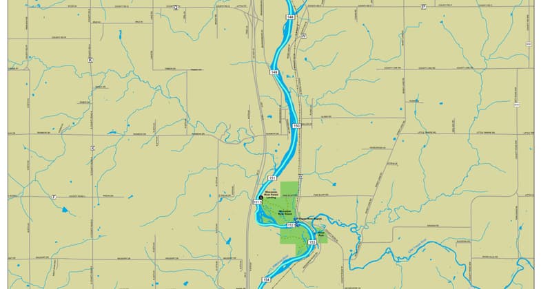
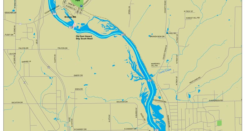
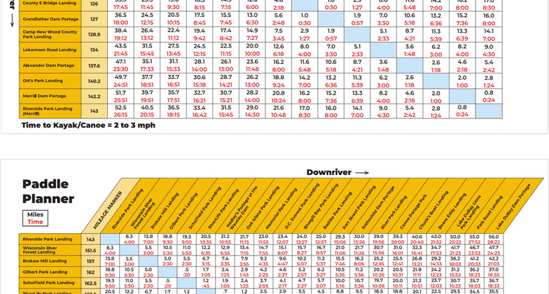
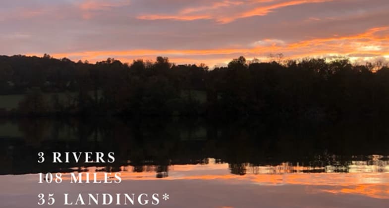
The Great Pinery Heritage Waterway (www.greatpinery.com) is an overarching water trail encompassing 108-miles (20.8 miles are designated as a National Water Trail) of the historic Wisconsin River. The trail flows through old growth pine and hardwood forest, paralleling portions of the Ice Age National Scenic Trail on its journey. The trail cuts through natural wildlife areas and flows past historical dams and once thriving mill towns, where White Pine was once king. It also passes urban and industrial areas, earning the river the well-deserved name the “Hardest Working River in the World.” The uniqueness of the trail is expressed in the storytelling at each of its 35 landings and portages.


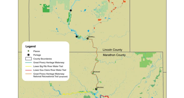
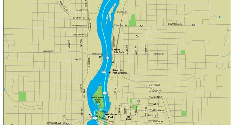
Location: The Great Pinery Heritage Waterway starts at Riverside Park (Merrill) in Lincoln County and ends at RiverLife Park (Wausau) in Marathon County.
- States: Wisconsin
- Counties: Lincoln, Marathon
- Cities/Townships: Merrill, Maine, Wausau
The Great Pinery Heritage Waterway (www.greatpinery.com) is an overarching water trail that is in North Central Wisconsin. The trail is 108-miles in length (20.8 miles are designated as a National Water Trail) starting at the Hat Rapids Dam in Oneida County and ending in Portage County at the Lake DuBay Dam.
The trail holds scenic wonders as it flows over rapids and rock outcroppings, through old growth pine and hardwood forest, paralleling portions of the Ice Age National Scenic Trail. The trail crosses natural wildlife areas, and state parks, and flows past historic dams, CCC camps, and once thriving mill towns, where White Pine once was king. The trail beckons us back to a time when the Ojibwa called the great river Meskonsing. It was our state’s first superhighway, where European explorers, fur traders, missionaries and frontiersmen transferred goods for furs and, more importantly, traded ideas between cultures. The great river is never far from our imagination, fast flowing, scenic in its northern segments to urban and industrial as it flows south through cities that once had names such as Jenny Falls, Big Bull, and Little Bull Falls.
The river has always been a gateway to the north, to the “Great Pinery”, the great white pine forest that blanketed the lands to the great lake the Ojibwa called Gitchi Gami. In the 1870’s the river earned a new name as the “Hardest Working River in the World” when the river was put to work sawing lumber for the cities and homes of the Midwest. In 1907 a group of private interests, called the Wisconsin Valley Improvement Company, was established to manage and regulate the flow of the Wisconsin River so that hydroelectric energy and the papermaking industry could develop and flourish.
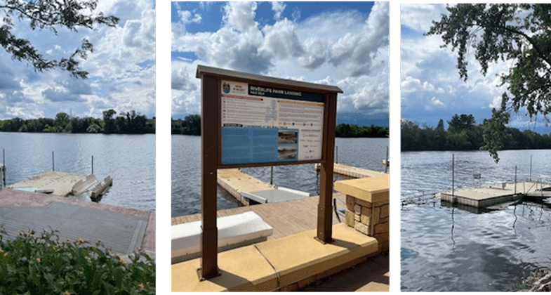
Today, the Wisconsin has returned to its beginnings offering the paddler an adventure not soon forgotten! The trail’s uniqueness lies in the storytelling at 35 landings and portages on its journey south. The Great Pinery Heritage Waterway is more than a river trail, it is a storytelling trail of the people, events, and geology of this historic river from ancient times to the mid-twentieth century. Each landing and portage have kiosks with storyboards that tell those stories in a unique way from its geology and wildlife to its legend and lore of rivermen such as, “Whiskey Jack”, wilderness pioneer Bill Cross, and fur trader, John Baptiste DuBay. The trail connects new generations to that distant past from which we arrived and offers insights into where we are going. By integrating QR codes into the trail signage, additional insights and stories can be accessed to enhance one’s journey and connection to the river.
Trail amenities such as restrooms, parking, typical paddle time between landings, parks, and camping have been included along with paddle guides on each segment of the trail. An interactive map and downloaded trail maps take the drudgery and fear out of trip planning, making a family trip on the Great Pinery an exercise in fun. Additionally, a paddler’s journey is enhanced by the incorporation of technology such as paddle apps that help with trip planning, safety and weather to GIS locators that give the exact locations to each landing and portage.
We live in a social world where we want to share experiences and our adventures in real time with friends and family. For that reason, Wi-Fi connectivity has been mapped along the trail offering instant communication if one so desires. Special docks and launches have been incorporated into the trail at heavy use areas so that the fear of entering or exiting a kayak or canoe is minimized. A number of these are ADA approved launches which open the trail to people with disabilities. The long-term goal is for each heavily used paddle area to have an ADA approved launch. John Muir once said, “The rivers flow not past, but through us.” The Great Pinery Heritage Waterway is one of those special rivers connecting communities, connecting time to place, and people to events.
Accessibility Information
All the landings have a GPS coordinates that pinpoints put-in and take-out locations. The trail has one ADA compliant dock/launch located at RiverLife Park in Wausau and four universal dock/launches that open the waterways for all ages and abilities. Many of the remaining landings are a combination of concrete ramps with adjoining docks or sand bottoms. Adjacent to the ADA compliant dock/launch is an ADA compliant restroom and parking. A rental station exists south of the proposal trail that is located on the D.C. Everest Park Landing that uses a credit card system to reserve and checkout kayaks for users. ADA compliant and universal dock/launches have been included on the website with images and GPS coordinates.
Allowed Uses:
Boating, motorized Swimming OtherOther Activities
- Camping
- Fishing
- Heritage and history
- Wildlife viewing / observation
- Other
Public Contact
WILLIAM C BERTRAM, Board PresidentWausau & Marathon County Parks and Recreation Foundation
212 River Drive
Wausau, WI 54403
[email protected] • 17152128188
More Details
- Elevation (low): --
- Elevation (high): --
- Elevation (cumulative): --
- Part of a Trail System? Yes
- System Name: Lower Wisconsin State Riverway
- System Length: 112.8 miles
- State Designations: State Designated Water Trail
- Surface (primary): Water, slow moving
- Surfaces (additional): Water, rapids, Water, swift moving, Water, calm
- Tread Width (average): --"
- Tread Width (minimum): --
- Running length (minimum): --
- Tread Grade (average, percent): --
- Tread Grade (maximum):
- Running length (maximum): --
- Cross-slope (average, percent): --
- Cross-slope (maximum): --
- Running length (maximum): --
- Certified as an NRT
Jun 8, 2025