Great Allegheny Passage
check with the trail manager for updated details before visiting.
Great Allegheny Passage
Nonprofit
Backcountry Trail
Rail Trail
Urban Trail
- Length
150 miles
- Elevation Gain
--
- Route Type
out & back
- Length
150 miles - Elevation Gain
-- - Route Type
out & back
This trail currently runs 135 from near Pittsburgh to Cumberland, MD where it joins the C&O Canal Towpath trail. It provides free recreation on a nearly level rail trail as well as access to rivers and opportunities to observe wildlife.
2025 Photo Contest Winner - Arts and Interpretation Category. Photo by Robert Kauffman

Winner 2024 NRT Photo Contest, Historic Features

Cumberland biking below Lowers Leap. Photo by Doug Riegner.

Keystone Viaduct

The Great Allegheny Passage crosses the eastern continental divide as it passes under a road. Photo by Mary Shaw.

Winner 2022 NRT Photo Contest, Trail Sharing. Photo by Rocio J. Paul.

A 2% grade makes the trail accessible to these 4-wheelers. Photo by Robert Kauffman.

A “rafter†of turkeys crossing the GAP Trail next to the entrance of Borden Tunnel near Frostburg. Photo by Robert B. Kauffman.

Rail with Trail. Photo by Mary Shaw.

Volunteers at Work. Photo by Mary Shaw.
Location: Pittsburgh, PA to Cumberland, MD
- States: Maryland, Pennsylvania
- Counties: Allegheny, Westmoreland, Fayette, Somerset
The Great Allegheny Passage (GAP) is a 150-mile multiple-use rail-trail system between Cumberland, MD and Pittsburgh, PA. Completed in 2013, the GAP links to the 185-mile C&O Canal Towpath in Cumberland and provides a non-motorized, nearly level trail between Washington, DC and Pittsburgh, PA.
The trail has a compacted crushed limestone surface. Following abandoned railroad beds, the average grade is less than 1%. The steepest section is westbound from Cumberland to Deal at 1.75%. Near the Big Savage Tunnel, the trail crosses the Eastern Continental Divide.
The trail is maintained by the Allegheny Trail Alliance, a coalition of seven trail organizations in southwestern Pennsylvania and western Maryland. The group is also charged with promoting and enhancing the trail and providing maps and tourist information.
The GAP received over a million visits in 2016, an increase of nine percent over the prior year. A key feature of the GAP is the Trail Town Program® which focuses on cooperation and economic development around trail tourism and outdoor recreation. The goal is to ensure that trail communities and businesses maximize the economic potential of the region's trails while working to improve the connections between trail and town.
A 2008 study of the trail found that, on average, business owners indicated that one-quarter of their gross revenue was directly attributed to trail users. A 2014 survey found that 62% of trail users included an overnight stay and spent an average of $124.58. This has increased by $26 since the 2008 trail user survey. The average day user spends roughly $18.
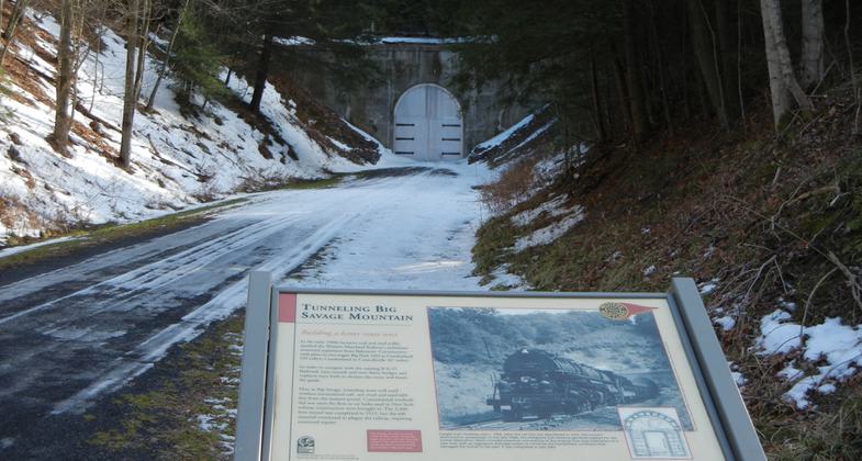
A popular feature is the Big Savage Tunnel, the longest of three major tunnels along the route. The 3,294-foot tunnel was built in 1911-12 through Big Savage Mountain near the PA-MD border. Last used by the railroad in 1975, the flooded and damaged tunnel was the major obstacle to getting over the mountain between Frostburg and Meyersdale. To have the tunnel drained, repaired, stabilized, and developed for trail use cost nearly $13 million. It was officially reopened in 2008.
The GAP can trace its beginning to 1978 when the Western Pennsylvania Conservancy purchased the first section of right-of-way from the Western Maryland Railway. In 1986 the first of many rail-trail conversion projects route opened 9.5 miles of trail in Ohiopyle State Park. In June 2013, thirty-five years after construction first began, the final GAP section was completed (from West Homestead to Pittsburgh) at an overall cost of $80 million.
For more information contact the Allegheny Trail Alliance at P.O. Box 501, Latrobe, PA 15650, or email [email protected]. Visit the ATA website at www.GAPtrail.org.
Accessibility Information
No text provided.
Allowed Uses:
Bicycling Boating, motorizedOther Activities
- Camping
Public Contact
Bryan PerryAllegheny Trail Alliance
P.O. Box 228
Homestead, PA 15120
[email protected]
www.gaptrail.org
Contact the trail manager for current maps and visiting details.
More Details
- Elevation (low): 715
- Elevation (high): 2392
- Elevation (cumulative): --
- Part of a Trail System? No
- National Designations: Community Millennium
- Surface (primary): Rock, crushed
- Surfaces (additional): Paved
- Tread Width (average): 120"
- Tread Width (minimum): --
- Running length (minimum): --
- Tread Grade (average, percent): --
- Tread Grade (maximum): 2
- Running length (maximum): --
- Cross-slope (average, percent): --
- Cross-slope (maximum): --
- Running length (maximum): --
- Certified as an NRT
n/a