Grays Peak Trail
check with the trail manager for updated details before visiting.
Grays Peak Trail
USDA Forest Service
Backcountry Trail
- Length
3.3 miles
- Elevation Gain
--
- Route Type
out & back
- Length
3.3 miles - Elevation Gain
-- - Route Type
out & back
This 3.3-mile hiking trail takes you from the trailhead to the summit of 14,278' Grays Peak. From the summit, a loop trail takes you north to the summit of 14,275' Torreys Peak, then back to the Grays Peak trail. The trail is entirely above the timberline.
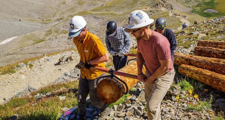
2023 Photo Contest Winner: Trail Work. Photo by David Kennedy

A volunteer with Volunteers for Outdoor Colorado and Colorado Fourteeners Initiative move logs at around 13,000 feet on the Grays Peak Trail. These were installed as check steps on the trail to prevent erosion.

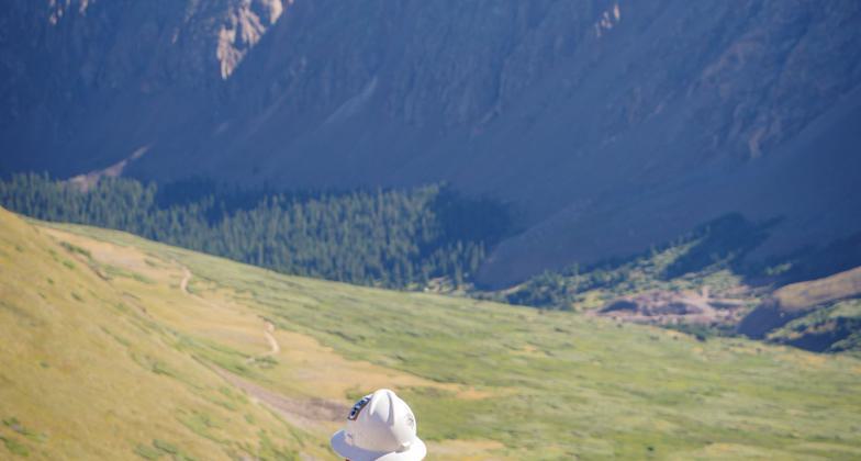
A volunteer with Volunteers for Outdoor Colorado and Colorado Fourteeners Initiative takes a break from trail work to enjoy the view, looking down the Grays Peak trail.

Continental Divide Trail access sign and footbridge at Grays Peak Trailhead. Photo by Xnatedawgx, wiki commons.

Information boards at Grays Peak Trailhead. Photo by Xnatedawgx, wiki commons.

Rock cairn on Grays Peak Trail. Photo by Xnatedawgx, wiki commons.

Grays Peak Trail viewed from high on Grays Peak. Photo by Xnatedawgx, wiki commons.

Grays Peak Trail almost from the top. Photo by Pimlico27/wiki.
Location: 19 miles west of Idaho Springs, CO on I-70., in Arapaho National Forest 3 mi. S of I-70, near the end of Clear Creek County Rd. #321.
- States: Colorado
- Counties: Clear Creek
This trail is a 3.3-mile trail to the top of 14,278-foot Grays Peak, the highest point on the Continental Divide.
Grays Peak was first climbed in 1861 by botanist Charles Parry, who named it for a colleague, Asa Gray. At the same time, Parry climbed Torreys Peak to the north, naming it after another colleague, John Torrey.
The trail is maintained by the Colorado Fourteeners Initiative, an organization devoted to the protection and preservation of Colorado's 14,000-foot peaks.
The trail is extremely popular and sees heavy use during the summer months. A side trail takes the climber north to Torreys Peak, then loops back to rejoin the Grays Peak trail. The trailhead is just at the timberline and the trail is above the timberline for its entire length. Trail users are advised to begin hiking early and return before afternoon storms develop. Be prepared with plenty of water, sunscreen, adequate footwear, and sufficient clothing to be prepared for sudden changes in weather.
Accessibility Information
No text provided.
Allowed Uses:
Dogs, on leash Hiking/WalkingOther Activities
- Wildlife viewing / observation
Public Contact
Ralph BradtUS Forest Service, Clear Creek Ranger District
PO Box 3307
Idaho Springs, CO 80452
[email protected] • (303) 567-3017
Contact the trail manager for current maps and visiting details.
More Details
- Elevation (low): 12110
- Elevation (high): 14278
- Elevation (cumulative): --
- Part of a Trail System? No
- National Designations: Continental Divide National Scenic Trail
- Surface (primary): Rock, smooth
- Surfaces (additional): Rock, smooth
- Tread Width (average): 24"
- Tread Width (minimum): --
- Running length (minimum): --
- Tread Grade (average, percent): 20
- Tread Grade (maximum): 30
- Running length (maximum): --
- Cross-slope (average, percent): --
- Cross-slope (maximum): --
- Running length (maximum): --
- Certified as an NRT
Dec 12, 1979