Frisco Highline Trail
check with the trail manager for updated details before visiting.
Frisco Highline Trail
Nonprofit
Frontcountry Trail
Rail Trail
Urban Trail
- Length
36 miles
- Elevation Gain
--
- Route Type
out & back
- Length
36 miles - Elevation Gain
-- - Route Type
out & back
The Frisco Highline Trail is the longest Rail-Trail in Missouri, at 36 miles, and connects Springfield to Bolivar, Missouri, with several historic rural farm towns along the route. Bicyclists, runners, and walkers enjoy the Ozarks' scenery there in all seasons. Harry S. Truman got the idea for his Whistle Stop Campaign for President after traveling the Highline railroad from Bolivar to Springfield and back in the summer of 1948. On the north half of the trail, there are 16 railroad trestles to cross over. The trail also passes through La Petite Gem Prairie, a rare native jewel.
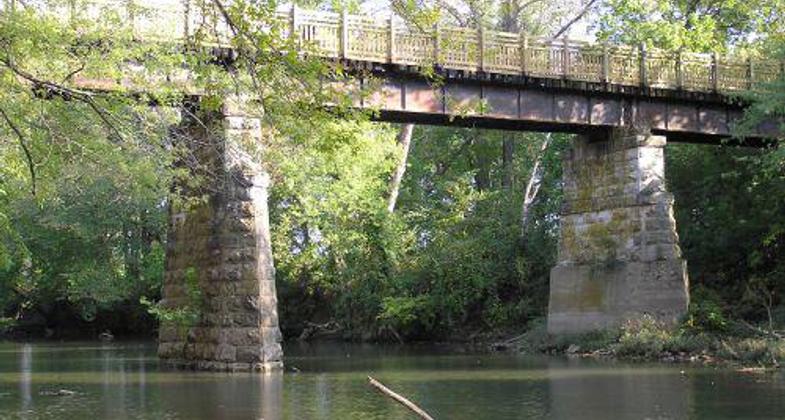
The Frisco Highline Trail crosses 16 railroad bridges, including this 1880's beauty on the Little Sac River, at mile marker 23.
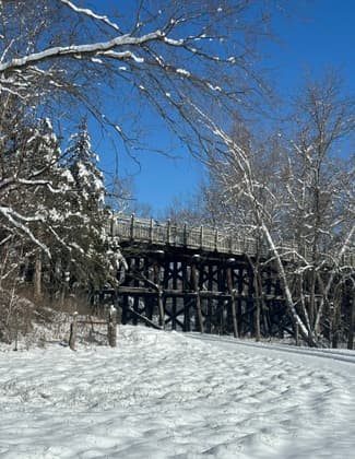
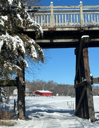
My view of the whistle stop
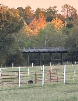
Landowners view of the whistle stop bridge
Landowners view of the whistle stop bridge


Location: Connects Springfield north to Bolivar, Missouri, part along State Route 123
- States: Missouri
- Counties: Greene, Polk
- Cities/Townships: Springfield, Willard, Walnut Grove, Wishart, Bolivar
The Frisco Highline Trail is the second longest Rail-to-Trail conversion in Missouri, at 36 miles long, connecting Springfield to Bolivar. It provides free, safe non-motorized use opportunities for walking, running, bicycling, commuting, touring, and wheelchair use.
This historic scenic corridor connects several railroad towns, including Springfield, Willard, Walnut Grove, Graydon Springs, Wishart, Pearl, Morrisville, and Bolivar. In fact, Harry S. Truman got the idea for his Whistle Stop Campaign for President after traveling the Frisco Highline railroad from Bolivar to Springfield and back in the summer of 1948.
On the north half of the trail, there are 16 railroad trestles to cross over. The trail passes through La Petite Gem Prairie, one of the most diverse prairies in Missouri, according to the Missouri Prairie Foundation.
This trail is changing the southwest Missouri region by shedding new light on health issues related to sedentary lifestyles. People who have never been active in their lives are getting out onto the trail. Not just nature-craving city folks, but also rural residents are enjoying the trail for recreation, exercise, transportation, and spending time with friends and family. The success of this trail has resulted from the increased public demand for further greenway development around the Springfield community.
The uniqueness this trail has to offer is incredible scenery though - a real rural Missouri experience. In one of the fastest-growing areas of the state, we need to highlight the importance of preserving this rural cultural heritage, before the farms all become subdivisions.
Accessibility Information
No text provided.
Allowed Uses:
Bicycling Dogs, on leash Hiking/Walking Snow, cross-country skiingOther Activities
- Fishing
- Heritage and history
- Snow, snow play general
- Wildlife viewing / observation
Public Contact
Lori TackOzark Greenways
PO Box 50733
Springfield, MO 65805
[email protected] • (417) 864-2015
Contact the trail manager for current maps and visiting details.
More Details
- Elevation (low): 870
- Elevation (high): 1270
- Elevation (cumulative): --
- Part of a Trail System? No
- Surface (primary): Rock, crushed
- Surfaces (additional): Paved, Rock, crushed
- Tread Width (average): 127"
- Tread Width (minimum): --
- Running length (minimum): --
- Tread Grade (average, percent): 2
- Tread Grade (maximum): 4
- Running length (maximum): --
- Cross-slope (average, percent): --
- Cross-slope (maximum): --
- Running length (maximum): --
- Certified as an NRT
May 31, 2006