Duncan Ridge Trail
check with the trail manager for updated details before visiting.
Duncan Ridge Trail
USDA Forest Service
Backcountry Trail
- Length
35.5 miles
- Elevation Gain
--
- Route Type
out & back
- Length
35.5 miles - Elevation Gain
-- - Route Type
out & back


Location: In Chattahoochee National Forest, links the Appalachian NST N of Springer Mountain to DeSoto Falls.
- States: Georgia
- Counties: Union
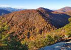
This challenging trail follows high, dry ridges for most of its length. The trail begins on Long Creek near Three Forks, on the Appalachian Trail, goes north, and crosses the Toccoa River on a 260-foot swinging bridge. The trail then leads north and west along Duncan Ridge through Mulky Gap to Slaughter Gap. It includes many steep climbs and descents over several mountain tops. The trail is blue-blazed for all of this section but also has yellow blazes on the eastern portion, where the Coosa Backcountry Trail shares the same treadway and also will have the white diamonds of the Benton MacKaye Trail from Long Creek Falls for Rhodes Mountain. About 1.25 miles on the eastern end are within the Blood Mountain Wilderness. A 60-mile loop trail can be made by combining this trail with the Appalachian Trail.
Accessibility Information
No text provided.
Allowed Uses:
Hiking/WalkingPublic Contact
Cassius CashChattahoochee-Oconee National Forest
6060 Appalachian Hwy.
Blue Ridge, GA 30513
[email protected] • (706) 632-3031
www.fs.fed.us/conf
Contact the trail manager for current maps and visiting details.
More Details
- Elevation (low): 1920
- Elevation (high): 4271
- Elevation (cumulative): --
- Part of a Trail System? No
- Surface (primary): Soil
- Surfaces (additional): Soil
- Tread Width (average): 18"
- Tread Width (minimum): --
- Running length (minimum): --
- Tread Grade (average, percent): 8
- Tread Grade (maximum): 20
- Running length (maximum): --
- Cross-slope (average, percent): --
- Cross-slope (maximum): --
- Running length (maximum): --
- Certified as an NRT
Aug 17, 1980