Dog Canyon Trail
check with the trail manager for updated details before visiting.
Dog Canyon Trail
USDA Forest Service
Backcountry Trail
- Length
5.5 miles
- Elevation Gain
--
- Route Type
out & back
- Length
5.5 miles - Elevation Gain
-- - Route Type
out & back
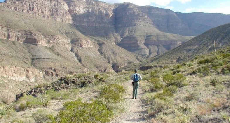
Follows Dog Canyon to east towards Sacramento Mts. Gain of 3,130 ft. Passes through examples of Chihuahuan desert, canyon riparian and woodland environments.
Location: The Lower Trailhead is located at Oliver Lee Memorial State Park, 14 miles south of Alamogordo, New Mexico. The Upper Trailhead is located on Forest Road 90B, 21 miles south of High Rolls, New Mexico.
- States: New Mexico
- Counties: Otero
Follows Dog Canyon to the east towards Sacramento Mts. Gain of 3,130 ft. Passes through examples of the Chihuahuan desert, canyon riparian, and woodland environments.
Trail #106: The National Recreation Dog Canyon Trail is 5.5 miles long. It begins at Oliver Lee State Park and ends at Forest Road 90B. This beautiful trail traverses up from the desert to elevations over 2000' above its starting point and is a trail for the experienced hiker. The trail is open for hiking and horseback riding.
Accessibility Information
No text provided.
Allowed Uses:
Dogs, on leash Hiking/WalkingOther Activities
- Camping
Public Contact
Marcie KeltonUSDA Forest Service, Lincoln National Forest
Sacramento Ranger District
Cloudcroft, NM 88317
[email protected] • (575) 682-2551
www.fs.usda.gov/lincoln
Contact the trail manager for current maps and visiting details.
More Details
- Elevation (low): 4420
- Elevation (high): 7544
- Elevation (cumulative): --
- Part of a Trail System? No
- Surface (primary): --
- Surfaces (additional): --
- Tread Width (average): 18"
- Tread Width (minimum): --
- Running length (minimum): --
- Tread Grade (average, percent): 30
- Tread Grade (maximum): 50
- Running length (maximum): --
- Cross-slope (average, percent): --
- Cross-slope (maximum): --
- Running length (maximum): --
- Certified as an NRT
Jan 20, 1981