Discovery Trail
check with the trail manager for updated details before visiting.
Discovery Trail
USDA Forest Service
Backcountry Trail
- Length
1.2 miles
- Elevation Gain
--
- Route Type
out & back
- Length
1.2 miles - Elevation Gain
-- - Route Type
out & back
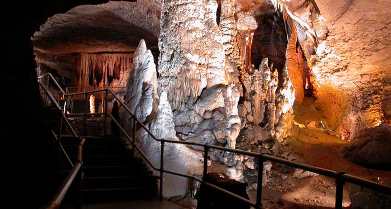
Blanchard Springs Caverns is one of the most spectacular and carefully developed caves found anywhere in the world. The active cave, with its glistening formations, stalactites, stalagmites and flowstones is constantly changing, providing return visitors something new to see each time. Beautifully lighted rooms, that accentuate the cave's features, are equipped with handrails and paved trails for comfortable walking.
Location: Blanchard Caverns Recreation Area on the Sylamore Ranger District on the Ozark-St. Francis National Forest. The trail is located 280 feet below the ground under the Visitor Center.
- States: Arkansas
- Counties: Stone
- Cities/Townships: Fifty Six
Blanchard Springs Caverns is one of the most spectacular and carefully developed caves found anywhere in the world. The active cave, with its glistening formations, stalactites, stalagmites, and flowstones is constantly changing, providing return visitors something new to see each time. Beautifully lighted rooms, that accentuate the cave's features, are equipped with handrails and paved trails for comfortable walking.
The Discovery Trail is another of the tours that are available at Blanchard Springs Caverns. This tour will last 1-1/2 hours. This one is a bit more complex than the Dripstone Trail. It is in the lower portion of the Caverns. The Discovery Trial will bring you 366 feet into Mother Earth and is 1.2 miles long. This section of the caverns was discovered in 1963 by two local cavers and is the largest of the three different sections. There are nearly 700 stair steps on this tour so if you have walking or health problems this one isn't for you. On this tour, you'll take the routes of the early explorers and pass through the campsites of their early expeditions. You'll look up through the natural entrance where those early explorers dangled from ropes on homemade harnesses. You will see the underground stream which eventually gushes from Blanchard Springs. This section of the Caverns is not filled with the formations of the Dripstone Trail, it is the first place where you will see the stream that runs through the caverns assisting in the creation of the caverns
Accessibility Information
No text provided.
Allowed Uses:
No data provided.
Other Activities
- Caving
- Heritage and history
- Wildlife viewing / observation
Public Contact
William AveyUSDA Forest Service
1001 E. Main
Mountain View, AR 72560
[email protected] • 870-757-2211
Contact the trail manager for current maps and visiting details.
More Details
- Elevation (low): 650
- Elevation (high): 720
- Elevation (cumulative): --
- Part of a Trail System? No
- Surface (primary): Paved
- Surfaces (additional): Paved
- Tread Width (average): 48"
- Tread Width (minimum): 32
- Running length (minimum): --
- Tread Grade (average, percent): 5
- Tread Grade (maximum): 5
- Running length (maximum): --
- Cross-slope (average, percent): 2
- Cross-slope (maximum): --
- Running length (maximum): --
- Certified as an NRT
Feb 23, 2009