Des Plaines River Trail - Lake County
check with the trail manager for updated details before visiting.
Des Plaines River Trail - Lake County
City, Town, or County
- Length
31.4 miles
- Elevation Gain
--
- Route Type
out & back
- Length
31.4 miles - Elevation Gain
-- - Route Type
out & back
The Des Plaines River Trail is a scenic multi-use trail that spans nearly the entire length of Lake County, Illinois for 31.4 miles as it winds through 12 forest preserves. Meandering along the Des Plaines River, the regional gravel trail is open for hiking, biking, cross country skiing, horseback riding and snowmobiling in some sections in winter. The trail follows the river's edge from Russell Road in Wadsworth south to Lake-Cook Road where it connects to the Cook County Forest Preserve Trail.
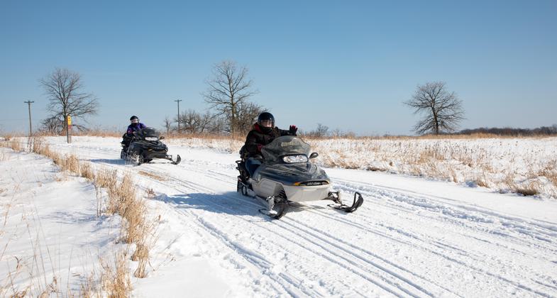
2025 Photo Contest Winner - Snowmobiling Category. Photo by Justine Neslund

Winter view of Des Plaines River from trail bridge in Captain Daniel Wright Woods Forest Preserve.

Des Plaines River Trail bridge in Independence Grove in Autumn.

The Des Plaines River Trail provides views of many small lakes, ponds and streams.

Summer on the Des Plaines River Trail.

Final connection completes Des Plaines River Trail. Only took 54 years!

Equestrian on Des Plaines River Trail

Des Plaines River Trail through Half Day Forest Preserve

Des Plaines River Trail within Independence Grove Forest Preserve.

the Des Plaines River Trail crosses the river and its tributaries many times over its 31.4 miles.
Location: Lake County, IL
- States: Illinois
- Counties: Lake
- Cities/Townships: See attached
Escape the hustle and bustle of everyday life to a place where the main sounds you'll hear are the chirping of birds and the splashing of fish. No matter what time of year, the Des Plaines River Trail unveils a kaleidoscope of colors and natural beauty. The continuous uninterrupted north/south 31.4-mile path crisscrosses the Des Plaines River from the top of Lake County in Van Patten Woods Forest Preserve in Wadsworth to Lake-Cook Road where it connects to the Cook County Preserve Trail.
Stunning views are enjoyed along the multi-use path that winds through 12 forest preserves. Many of those preserves along the Des Plaines River Trail provide trail access and parking and connect with the wider preserve system and associated amenities. The regional trail is open for hiking, biking, cross-country skiing, horseback riding, and snowmobiling in some sections during the winter. One of the largest forest preserves that the Des Plaines River Trail runs through is Independence Grove in Libertyville, which is a reclaimed gravel quarry and provides a number of activities from fishing to outdoor concerts. Six canoe launches spaced along the Des Plaines River Trail and Greenway provide river access for a variety of water activities, including shoreline fishing, canoeing, and kayaking.
The Des Plaines River Trail and Greenway protects land along more than 76 percent of the river in Lake County, providing wildlife habitat, natural flood protection, and outdoor recreation opportunities. It is a key link in a regional network of trails that includes the North Shore Bike Path, the McClory Trail, and the Millennium Trail.
The river and its seasonal rise and fall help determine which plants and animals live along the trail. Beavers, herons, and turtles are a few of the native animals adapted to river life. Oaks, hickories, and maples are some of the common trees.
As you travel through this river corridor look for changes in the landscape. In northern Lake County, the floodplain is wide, and the river meanders. In southern Lake County, the river is narrow and runs a straighter course. Open areas such as prairies and oak savannas are common to the west of the river. Maple woodlands are more common on the eastern bank of the river, which blocked ancient wildfires from the west.
Preservation of the greenway surrounding the trail has been a key priority since the early years of our district with the river serving as a backbone to thousands of acres of contiguous, lush open space. In the mid-1970s, the vision for the trail along the greenway began to crystalize. Over the next three decades, the Des Plaines River Trail grew, section by section. In October 2015 the trail was complete, fulfilling a vision 54 years in the making for this contiguous regional trail system.
Accessibility Information
No text provided.
Allowed Uses:
Bicycling Boating, human-powered Dogs, on leash Equestrian Hiking/Walking Snow, cross-country skiing Snow, snowshoeingOther Activities
- Fishing
- Heritage and history
- Snow, snow play general
- Wildlife viewing / observation
Public Contact
John NelsonLake County Forest Preserve District
1899 West Winchester Road
Libertyville, IL 60048
[email protected] • 847-367-6640
Contact the trail manager for current maps and visiting details.
More Details
- Elevation (low): 637
- Elevation (high): 721
- Elevation (cumulative): --
- Part of a Trail System? No
- Surface (primary): Rock, crushed
- Surfaces (additional): Paved, Boardwalk
- Tread Width (average): 120"
- Tread Width (minimum): 104
- Running length (minimum): --
- Tread Grade (average, percent): --
- Tread Grade (maximum): 7
- Running length (maximum): --
- Cross-slope (average, percent): 2
- Cross-slope (maximum): --
- Running length (maximum): --
- Certified as an NRT
Oct 25, 2020