Daniel Boone Scout Trail
This information is a public record of the 1982 NRT application and may be out of date if it has not been updated by a trail manager --
check with the trail manager for updated details before visiting.
check with the trail manager for updated details before visiting.
Daniel Boone Scout Trail
State
Backcountry Trail
- Length
3 miles
- Elevation Gain
--
- Route Type
out & back
- Length
3 miles - Elevation Gain
-- - Route Type
out & back

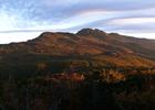
Raven Rocks and Calloway Peak, as the rising sun illuminates the brilliant fall foliage on the southeastern face of Grandfather. Photo by Ken Thomas.
Location: backcountry
- States: North Carolina
- Counties: Watauga
Ascends 2000 feet over 2.6 miles to the summit of Calloway Peak, the highest point in Blue Ridge Range. Good views, cables, and ladders in steep sections.
Hiking/Camping permits are required. Permits are obtained via self-registration at a kiosk approximately .1 mile into the trail from the parking area. Camping is allowed only by reservation.
Accessibility Information
No text provided.
Allowed Uses:
Dogs, on leash Hiking/WalkingOther Activities
- Camping
- Wildlife viewing / observation
Public Contact
Grandfather Mountain State Park9872 N.C. 105 S.
Banner Elk, NC 28604
828-963-9522
Contact the trail manager for current maps and visiting details.
More Details
- Elevation (low): --
- Elevation (high): --
- Elevation (cumulative): --
- Part of a Trail System? No
- Surface (primary): --
- Surfaces (additional): --
- Tread Width (average): 72"
- Tread Width (minimum): --
- Running length (minimum): --
- Tread Grade (average, percent): --
- Tread Grade (maximum):
- Running length (maximum): --
- Cross-slope (average, percent): --
- Cross-slope (maximum): --
- Running length (maximum): --
- Certified as an NRT
Aug 16, 1982