Cuyahoga River Water Trail
check with the trail manager for updated details before visiting.
Cuyahoga River Water Trail
National Park Service
National Water Trail
- Length
41 miles
- Elevation Gain
187
- Route Type
out & back
- Length
41 miles - Elevation Gain
187 - Route Type
out & back
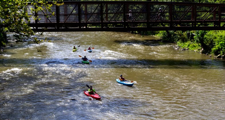
The Trail begins at the confluence of the Little Cuyahoga River and the Cuyahoga River main stem in Akron. The first access point, completed earlier this year, is located in the Valley View area of Cascade Valley Metropark; roughly half of a mile downstream from the confluence. From there, the river winds northward through the serene, natural landscape of Cuyahoga Valley National Park, which features 6 existing access points within the Park, with more access points currently under construction or planned. North of the Park, the river flows as the lifeblood of Cleveland's Industrial Valley before navigating the bustling heart of the City and ultimately pouring into Lake Erie. In total, the trail is 41 miles long and features 8 existing access points with two more access points currently under construction.


Location: The Cuyahoga River is a roughly 100-mile-long river in Northeast Ohio. The portion of the Cuyahoga River which we are applying for National Water Trail designation begins at the confluence of the Little Cuyahoga River and the Cuyahoga River main stem in the Cascade Valley Metropark area of Akron and Cuyahoga Falls, and runs north for approximately 41 miles to the mouth of the river at Lake Erie.
- States: Ohio
- Counties: Cuyahoga, Summit
- Cities/Townships: Cuyahoga Falls, Akron, Peninsula, Boston Township, Brecksville, Independence, Valley View, Cuyahoga Heights, Newburgh Heights, Cleveland
The Cuyahoga River Water Trail (CRWT), state-designated in 2019, is 90 miles long, flowing south and then turning sharply north towards Lake Erie, forming a large U shape in Northeast Ohio. The portion of the CRWT seeking National Water Trail designation begins at the confluence of the Little Cuyahoga River and the Cuyahoga River main stem, in the Cascade Valley area of Summit Metro Parks in Akron and Cuyahoga Falls. From beginning to end, this section of the river is roughly 41 miles long. The reason which Cuyahoga Valley National Park is not seeking designation of the entire length of the CRWT is because there is a large dam that cannot be portaged as well as a large reservoir that cannot be paddled upstream of the aforementioned confluence.
The first access point in this reach, Valley View Trailhead, sits roughly half a mile downstream from the confluence. Completed in 2024 on a large golf course-turned-park, which was restored to a more natural ecology by Summit County Metroparks, this trailhead is the southern anchor of the section seeking designation. From this access point, paddlers make their way downstream into Cuyahoga Valley National Park, where the Northampton Point access point is currently under construction, approximately eight river-miles from the Valley View trailhead. Construction of this access point will be complete in the Spring of 2025.
The roughly 26 miles of the CRWT through the National Park currently includes 6 existing access points and 1 access point currently under construction (Northampton Point to Rockside Road). This section is strictly paddling only - no tubing, floating or motorized craft are allowed. The national park section of the water trail is patrolled by river rangers and the volunteer River Patrol Team. This ranger-led volunteer group is instrumental in providing safety and preventative search and rescue information to river users. This section of the water trail through the national park provides paddlers with serene, forested landscapes as well as ample wayside interpretation and historical landscapes. Bald eagles, beaver and a diverse array of wildlife can be admired through this section.
Approximately seven miles downstream from the Northampton Point access point is Lock 29. However, Cuyahoga Valley National Park recently acquired the former Brandywine Golf Course Property within this section and plans to develop an access point on that site as well. Downstream of Lock 29 through the National Park features the highest concentration of paddling access and water trail use. This northern section of the National Park is also where water trail users can take advantage of the paddle-aboard program, where they can board Cuyahoga Valley Scenic Railroad with their kayaks and equipment and use the train as a shuttle to get from one end of their river journey to the other. Furthermore, users can engage in pedal-paddle opportunities thanks to the Ohio and Erie Canal Towpath Trail which also runs adjacent to the river and scenic railroad through this section. Boston, Red Lock, Station Road Bridge, Fitzwater and Lock 39 access points string along this reach of the river and provide ample access to the water trail.
North of Lock 39, paddlers exit the National Park and navigate the wooded banks of the Cuyahoga River towards Cleveland. Approximately six miles north of Lock 39, the nature of the water trail changes from a quiet, wooded river into the lifeblood of Cleveland’s Industrial Valley and the shipping channel. Through this section, towering freighters move vast quantities of iron ore and other materials to Cleveland’s colossal steel mills and industrial sites, highlighting the living industrial heritage and history of the Cuyahoga River. Information for how to navigate this section safely is available on the Cuyahoga River Water Trail website, and safety is supported by the Cleveland Argonaut vessel and other law enforcement entities.
This industrial heritage section is not as accessible as the southern portion of the water trail, and paddlers should be prepared for a longer paddle and be aware of how to paddle safely through this section. However, new access in this section is currently under construction at Zaclon Landing, which is roughly nine miles north of the Lock 39 trailhead and which will make this section less strenuous to navigate.
North of Zaclon Landing and the Industrial Valley, the nature of the water trail changes again. The heavy industry begins to give way to the downtown urban core of Cleveland. Riverfront restaurants and parks as well as pleasure boats, rowing teams, jet skis and paddleboarders can be found through this section of the water trail as the river approaches Lake Erie. Roughly 3 miles north of Zaclon Landing is Merwin’s Wharf, an ADA-accessible access point that allows users to explore downtown Cleveland from its foundational waterway. Finally, just a mile or so north of Merwin’s Wharf, the Cuyahoga River Water Trail ends at the river's mouth on Lake Erie.
Along these 41 river-miles, 8 existing access points and two access points currently under construction anchor public access to the Cuyahoga River Water Trail. From a quiet confluence through the natural beauty of parklands, to the stark industrial landscapes and bustling city life of Cleveland, the Cuyahoga River Water Trail offers a diverse array of opportunities for paddlers of all abilities and interests.
Accessibility Information
Merwin's Wharf, in downtown Cleveland, features several ADA-compliant access points. Furthermore, Cuyahoga Valley National Park's Community Access Plan (2023) identifies creating a more accessible water trail as a primary park goal, and specifically calls for the creation of ADA-accessible access points at two planned launch sites, and the addition of ADA-accessible access points at two existing sites.
Allowed Uses:
Boating, motorized Boating, human-poweredOther Activities
- Fishing
- Heritage and history
- Wildlife viewing / observation
Public Contact
Ryan Ainger, River RangerNational Park Service
Cuyahoga Valley National Park
15610 Vaughn Road
Brecksville, OH 44141
[email protected] • 4407590587
More Details
- Elevation (low): 571
- Elevation (high): 758
- Elevation (cumulative): 187
- Part of a Trail System? Yes
- System Name: Cuyahoga River Water Trail
- System Length: 87 miles
- National Designations: Cuyahoga National Heritage River, Ohio and Erie Canalway National Heritage Area
- State Designations: Ohio State Water Trail
- Surface (primary): Water, swift moving
- Surfaces (additional): Water, rapids, Water, slow moving
- Tread Width (average): --"
- Tread Width (minimum): --
- Running length (minimum): --
- Tread Grade (average, percent): --
- Tread Grade (maximum):
- Running length (maximum): --
- Cross-slope (average, percent): --
- Cross-slope (maximum): --
- Running length (maximum): --
- Certified as an NRT
Jun 8, 2025