Crystal Lake Shoreline Loop Trail
This information is a public record of the 1978 NRT application and may be out of date if it has not been updated by a trail manager --
check with the trail manager for updated details before visiting.
check with the trail manager for updated details before visiting.
Crystal Lake Shoreline Loop Trail
USDA Forest Service
Backcountry Trail
- Length
1.7 miles
- Elevation Gain
--
- Route Type
out & back
- Length
1.7 miles - Elevation Gain
-- - Route Type
out & back
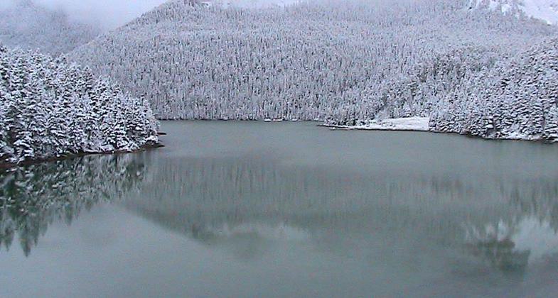
Crystal Lake in the Big Snowy Mountains in central Montana. Photo by USFS.

Crystal Lake in the Big Snowy Mountains in central Montana. Photo by USFS.

Crystal Lake in the Big Snowies. Photo by USFS.
Location: 30 Miles southwest of Lewiston, MT.
- States: Montana
- Counties: Fergus
Self-guided interpretative trail around edge of Crystal Lake includes information on the area ecosystem, and the processes that created it and continue to shape it today.
Accessibility Information
No text provided.
Allowed Uses:
Bicycling Boating, human-powered Swimming Dogs, on leash Hiking/WalkingOther Activities
- Camping
- Fishing
- Wildlife viewing / observation
Public Contact
Linda CasperLewis and Clark National Forest
Judith Ranger District
Stanford, MT 59479
[email protected] • (406) 566-2292
www.fs.fed.us/r1/lewisclark
Contact the trail manager for current maps and visiting details.
More Details
- Elevation (low): --
- Elevation (high): --
- Elevation (cumulative): --
- Part of a Trail System? No
- Surface (primary): --
- Surfaces (additional): --
- Tread Width (average): 24"
- Tread Width (minimum): --
- Running length (minimum): --
- Tread Grade (average, percent): --
- Tread Grade (maximum):
- Running length (maximum): --
- Cross-slope (average, percent): --
- Cross-slope (maximum): --
- Running length (maximum): --
- Certified as an NRT
Aug 21, 1978