Crown Zellerbach Trail
check with the trail manager for updated details before visiting.
Crown Zellerbach Trail
City, Town, or County
Backcountry Trail
Rail Trail
- Length
22 miles
- Elevation Gain
--
- Route Type
out & back
- Length
22 miles - Elevation Gain
-- - Route Type
out & back
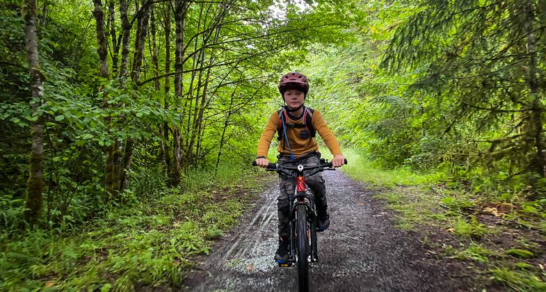
The Crown Zellerbach Trail is a 22 mile mostly-gravel trail connecting the towns of Scappoose and Vernonia Oregon through the wetlands of the Columbia River and the gentle, forested hills of Oregon's lush Coastal Range. Also known as the Crown Z Trail and CZ Trail, it follows mostly gentle grades originally built for a logging railway but later widened for logging trucks. This created a wide forest path suitable for today's hikers, bicyclists, and equestrians.


Location: The Crown Zellerbach rail-to-trail starts in Scappoose Oregon and continues 22 miles to Vernonia Oregon through wetlands of the Columbia River and farm/forest land of Oregon's Coastal Range.
- States: Oregon
- Counties: Columbia
- Cities/Townships: Scappoose and Vernonia
The Crown Zellerbach Trail has several features that make it an outstanding trail, including its topography, forest floor surface, close proximity to a major metropolitan area and international airport, suitability for all types of recreationists, and extensive interpretive signs.
Trail history and topography: The trail follows the drainages of two local creeks which originate at the Nehalem Divide, the highest point of the trail but one of the lowest passages crossing Oregon's Coastal Range. Its easy topography made it a likely trade route between the Chinookan Indians who lived along the Columbia River and the Clatskanie Indians whose range extended into the Nehalem Valley at the far end of the trail. By 1905, it became the obvious route for one of Oregon's first logging operations to build a rail line for hauling huge logs to the Columbia River where they could be easily floated to lumber mills. The railway was sold to the Crown Zellerbach Corporation in 1945 and later converted to a wide logging truck road. After the road fell into disuse, Columbia County acquired the right of way. The trail was opened to the public in 2014 and retains both the gentle grade of the rail line and the width of the subsequent logging road. The gravel path is more like a firm forest floor in most places allowing hikers, mountain bikers, and equestrians to immerse themselves in the surrounding forest and farmlands. Many sections of the trail are even suitable for road bikes. The online trail brochure describes each section in detail.
Accessibility: The 22 mile trail is accessible to visitors of all abilities and ages because of its mostly easy grade and because nine trailheads have been built every 3-4 miles along its 22 mile length. This allows visitors to choose a segment that best suits their time and ability. The first two miles are flat and paved and are especially suitable for strollers, wheelchairs and young children. Most sections have easy grades on fine gravel or firm forest floor. Only short sections near the two summits of the trail are steeper than 8%. See the online trail map for more information.
Service to Diverse Communities and Urban Populations: The trail is only 20 miles from downtown Portland and its diverse population, but is located in mostly rural farm and forestland. It is only 25 miles from Portland International Airport.
Connections to Other Trails: The Crown Z Trail connects to the 23 mile Banks-Vernonia State Trail which connects to other trails and rural roads to Oregon's Tualatin Valley vineyards and beyond to the Oregon Coast and Willamette Valley.
Educational Opportunities: The Crown Z Trail has 23 interpretive kiosks with 60 signs throughout its 22 mile length. The kiosks and signs highlight the local history, geology and wildlife at or near their location and convey the information with photographs and graphics. History topics range from indigenous peoples to apple orchards. The Crown Z Trail owes its existence to the railroad built to transport harvested timber. Consequently, logging and railroad operations and the people who worked in the forests are frequent subjects. Family pictures and stories were collected to illustrate the diversity of the people who lived along the trail during that era. Minority workers provided special skill sets and were responsible for specific jobs. Japanese laborers were an important component of the railroad operation and the life of one family is explored in detail. The Crown Z Trail website includes comprehensive information about the trail's history.
There are six geology interpretive signs that sequentially travel back millions of years to help visitors understand the effects of the powerful ancient rivers of molten rock that flowed from Idaho and massive glacial floods from Montana which created the land formations they see today. Natural history signs describe and picture local wildlife and plants.
Accessibility Information
No text provided.
Allowed Uses:
Bicycling Dogs, on leash Equestrian Hiking/Walking Snow, cross-country skiing Trail runningOther Activities
- Heritage and history
- Wildlife viewing / observation
Public Contact
Riley Baker, Director of General ServicesColumbia County Parks and General Services
230 Strand St Columbia Courthouse Annex
St. Helens, OR 97051
(503) 397-2353
www.columbiacountyor.gov/crownz-trail
More Details
- Elevation (low): 62
- Elevation (high): 1200
- Elevation (cumulative): --
- Part of a Trail System? No
- Surface (primary): Rock, crushed
- Surfaces (additional): Paved, Soil
- Tread Width (average): 180"
- Tread Width (minimum): 120
- Running length (minimum): --
- Tread Grade (average, percent): 6
- Tread Grade (maximum): 20
- Running length (maximum): --
- Cross-slope (average, percent): 1
- Cross-slope (maximum): --
- Running length (maximum): --
- Certified as an NRT
Jun 3, 2023