Crane Mountain Trail
This information is a public record of the 1979 NRT application and may be out of date if it has not been updated by a trail manager --
check with the trail manager for updated details before visiting.
check with the trail manager for updated details before visiting.
Crane Mountain Trail
USDA Forest Service
Backcountry Trail
- Length
36 miles
- Elevation Gain
--
- Route Type
out & back
- Length
36 miles - Elevation Gain
-- - Route Type
out & back
The Crane Mountain National Recreation Trail #161 is located east of Lakeview, Oregon in the Warner Mountains.

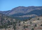
West face of Crane Mountain; the highest peak in Lake County, Oregon. Photo by Orygun/wiki.
Location: Fremont National Forest, In Fremont National Forest, SE of Lakeview, above Goose Lake State Recreation Area.
- States: Oregon
- Counties: Lake
The Crane Mountain Trail offers many scenic vista and diverse environments as it traverses the slopes and summit of rugged Crane Mountain, the highest point in Lake County at 8,357' above sea level. Seasonal wildflowers are abundant in July.
Accessibility Information
No text provided.
Allowed Uses:
Bicycling Dogs, on leash Equestrian Motorized vehicles, – ATV/ORVOther Activities
- Camping
Public Contact
Larry HillsFremont National Forest
HC 10, Box 337
Lakeview, OR 97630
[email protected] • (541) 947-6275
www.fs.fed.us/r6/fremont/trail
Contact the trail manager for current maps and visiting details.
More Details
- Elevation (low): 5626
- Elevation (high): 8357
- Elevation (cumulative): --
- Part of a Trail System? No
- Surface (primary): Soil
- Surfaces (additional): Soil
- Tread Width (average): 18"
- Tread Width (minimum): --
- Running length (minimum): --
- Tread Grade (average, percent): 6
- Tread Grade (maximum): 15
- Running length (maximum): --
- Cross-slope (average, percent): --
- Cross-slope (maximum): --
- Running length (maximum): --
- Certified as an NRT
Oct 4, 1979