Crag Crest Ski Trail
check with the trail manager for updated details before visiting.
Crag Crest Ski Trail
USDA Forest Service
Backcountry Trail
- Length
10.3 miles
- Elevation Gain
--
- Route Type
Loop
- Length
10.3 miles - Elevation Gain
-- - Route Type
Loop
The Crag Crest National Recreation Trail is a 10.3-mile circular trail consisting of a crest portion and a loop portion. It is recommended that you get an early start to avoid afternoon thunderstorms. This trail is known for its wildflower displays in spring.

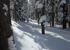
Whoever comes up next will have a much easier time of it with most of the trail broke to this point. Photo by GJHikes.

Photo by GJHikes.
Location: Grand Mesa National Forest
- States: Colorado
The Crag Crest National Recreation Trail is a 10.3-mile circular trail consisting of a crest portion and a loop portion. It is recommended that you get an early start to avoid afternoon thunderstorms.
It is accessed from two trailheads. One on the west end across from Island Lake and one on the east adjacent to Eggleston Lake.
The crest portion (6.5 miles) rises steeply from the East Trailhead to the top of Crag Crest. From the West Trailhead, the crest portion rises more gradually to the top of Crag Crest. Sections of the Craig Crest are on a narrow ridge with steep drop-offs on both sides. The loop portion (3.4 miles) provides an alternative return route.
Only foot travel is allowed on the crest portion between the East Trailhead and the Cottonwood Lakes Trail junction. Rocky drop-offs and narrow trails make any other type of passage unsafe.
Foot, mountain bike, and horse travel are allowed on the loop portion and on the crest portion between the West Trailhead and the Cottonwood Lakes Trail junction. Motorized vehicles are prohibited on all portions of the Crag Crest Trail.
The Crag Crest rises from 10,150 feet at Eggleston Lake to 11,189 feet along the crest. At the lower elevations, the trail passes through stands of Englemann spruce, subalpine fir, and open meadows. Quaking aspen, with leaves that are light green in the summer and brilliant yellow in the fall, grows among the dark green conifers. Patches of low-growing Oregon grapes are found in and near these forested areas.
The forests and meadows provide food and cover for big game animals such as elk and deer. They may be seen feeding in the open meadows in the early morning or late evening. Porcupines, snowshoe rabbits, pine squirrels, chipmunks, pocket gophers, red foxes, and various species of mice are some of the small mammals often seen along the trail. The pika or"cony" and the yellow-belly marmot can often be detected among the rocks. Ravens, woodpeckers, flickers, finches, hawks, blue grouse, chickadees, robins, jays, and hummingbirds are a few of the many kinds of birds that may be observed in the Crag Crest area.
Accessibility Information
No text provided.
Allowed Uses:
Snow, cross-country skiingOther Activities
- Snow, snow play general
Public Contact
John BeckleyGrand Mesa National Forest
2250 US Hwy. 50
Delta, CO 81416
Contact the trail manager for current maps and visiting details.
More Details
- Elevation (low): --
- Elevation (high): --
- Elevation (cumulative): --
- Part of a Trail System? No
- Surface (primary): --
- Surfaces (additional): --
- Tread Width (average): 0"
- Tread Width (minimum): --
- Running length (minimum): --
- Tread Grade (average, percent): --
- Tread Grade (maximum):
- Running length (maximum): --
- Cross-slope (average, percent): --
- Cross-slope (maximum): --
- Running length (maximum): --
- Certified as an NRT
Jul 18, 1983