Conotton Creek Bike Trail
check with the trail manager for updated details before visiting.
Conotton Creek Bike Trail
City, Town, or County
Backcountry Trail
Rail Trail
- Length
11.4 miles
- Elevation Gain
--
- Route Type
out & back
(1 review)
- Length
11.4 miles - Elevation Gain
-- - Route Type
out & back
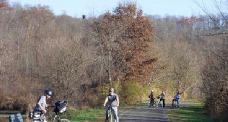
The Conotton Creek Trail is a Rails to Trails level 10-foot asphalt trail that was repaved in 2021 It traverses through the Conotton Valley parallel to the Conotton Creek It flows through wetlands farms woods rock formations three ponds and goes through five covered bridges that were built on original railroad bridge platforms. Wildlife includes a Great Blue Heron Rookery beside the trail A Great Blue American Bald Eagle nesting area beside the trail. Geese ducks turkeys turtles deer bats in bat boxes fox mink rabbits beaver with 2 beaver huts visible Interpretative signs along the trail and at 6 staging areas 50 benches 4 shelters four portable potties Handicap assess E-Bikes permitted travels through farmland rock formations trees ferns wildflowers swamps and through three villages which offer amenities for the traveler


Location: North Eastern Harrison County Ohio connecting towns of Bowerston Connotton Scio and Jewett all parallel to the Conotton Creek Access Ohio Rts 151 250 E 77S 70 E 22 W 43S 332 S
- States: Ohio
- Counties: Harrison
- Cities/Townships: North Rumley Monroe
The Conotton Creek Bike Trail is a designated rail trail of scenic serenity located in Northern Harrison County, Ohio. It traverses through the Conotton Valley parallel to Conotton Creek. The scenery includes ponds, rolling foothills, and three small towns.
Visitors on this mostly-wooded rail trail are sure to notice five covered bridges that were built on the original railroad bridge platforms. Once the corridor of the Wheeling and Lake Erie Railway, today the 11.2-mile Conotton Creek Trail offers complete immersion in a bucolic setting in northeastern Ohio. Situated in the rolling Appalachian foothills, the route has a significant coal-mining past. At one time, the line was used to transport iron ore from Great Lakes ports to the steel mills of the Ohio River Valley, and haul coal mined from Harrison County to markets in all directions. Today, one of the rail lines is still used, carrying coal, raw materials, and manufactured goods.
The paved multi-use trail is suitable for biking, roller-blading, jogging, and walking. The surface was repaved in 2021. The trail itself is of a typical width with plenty of open space on either side, making the trail exposed and hot in the summer. The entire trail is estimated to be a 5% or less grade. All-terrain tires or motorized equipment may be needed for the surface type. The trail features six bridges, two of which (in Scio and Jewett) are covered. The trail surface is coarse asphalt, wooden covered bridges (with edge barriers and railings), or a natural (grass) surface and smooth. It is typically at least six feet wide with wider passing spaces. There are benches and picnic tables along the route for resting.
The trail offers visitors the opportunity to experience wetlands, farms, forests, rock formations, and wildlife. The ponds east of Bowerston provide a wonderful environment for birding, as do the berried bushes along the route and more than 40 birdhouses. A colorful palette of wildflowers and pastoral landscapes dotted with horses and cattle completes the picturesque backdrop. There are interpretative signs at the five staging areas where ample parking is available.
Accessibility Information
No text provided.
Reviews
V Coffland
Great easy fast trail
Perfect for leisure ride or workout ride. Has places to stop along the route to enjoy the scenery, porta johns, in case you need one,? Great for family outing as well!
Allowed Uses:
No data provided.
Other Activities
- Camping
- Heritage and history
- Rock climbing
- Snow, snow play general
- Wildlife viewing / observation
Public Contact
Harry HorstmanHarrison County Conotton Creek Bike Committee
90151 Kilgore Ridge Road
Scio, OH 43988
[email protected] • 740-945-2172
Contact the trail manager for current maps and visiting details.
More Details
- Elevation (low): 951
- Elevation (high): 995
- Elevation (cumulative): --
- Part of a Trail System? No
- National Designations: Trail of the Month March 2002 Millennium Trail 2000 Hilary Clinton
- State Designations: Ohio River Trail Council Rails to Trail Conservancy
- Surface (primary): Paved
- Surfaces (additional): Paved, Grass or Vegetation, Rock, crushed, Sand
- Tread Width (average): 10"
- Tread Width (minimum): 10
- Running length (minimum): --
- Tread Grade (average, percent): 2
- Tread Grade (maximum): 2
- Running length (maximum): --
- Cross-slope (average, percent): 0
- Cross-slope (maximum): --
- Running length (maximum): --
- Certified as an NRT
Jun 2, 2022