Congdon Creek Park Trail
This information is a public record of the 1975 NRT application and may be out of date if it has not been updated by a trail manager --
check with the trail manager for updated details before visiting.
check with the trail manager for updated details before visiting.
Congdon Creek Park Trail
City, Town, or County
Urban Trail
- Length
0.8 miles
- Elevation Gain
--
- Route Type
out & back
- Length
0.8 miles - Elevation Gain
-- - Route Type
out & back
Location: N of downtown Duluth, follows creek from Superior St. NW to Vermilion Rd.
- States: Minnesota
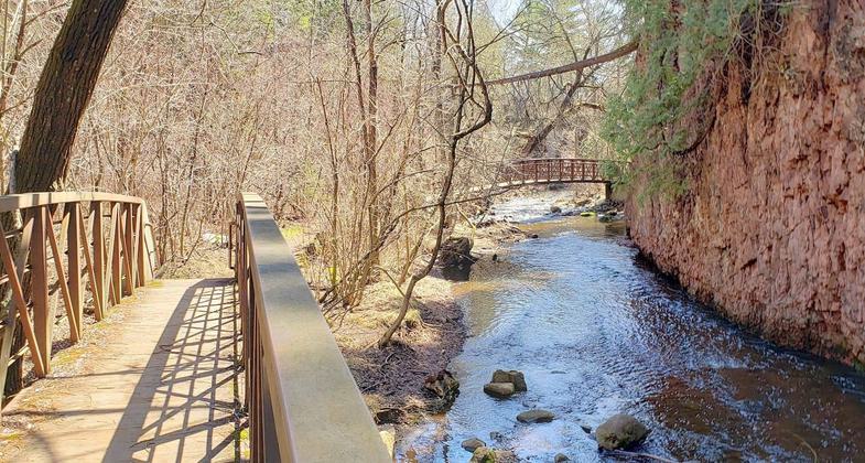
Located along Tischer Creek in the neighborhood that is named for it, Congdon Park features some of the most pristine hiking trails in Duluth, including beautiful bridges and stunning waterfalls. It was developed in 1908 on land donated by Chester Congdon, who was then building his Glensheen estate.
Accessibility Information
No text provided.
Allowed Uses:
Hiking/WalkingPublic Contact
Duluth Parks and Recreation DepartmentCity Hall
Duluth, MN 55802
Contact the trail manager for current maps and visiting details.
More Details
- Elevation (low): --
- Elevation (high): --
- Elevation (cumulative): --
- Part of a Trail System? No
- Surface (primary): --
- Surfaces (additional): --
- Tread Width (average): 0"
- Tread Width (minimum): --
- Running length (minimum): --
- Tread Grade (average, percent): --
- Tread Grade (maximum):
- Running length (maximum): --
- Cross-slope (average, percent): --
- Cross-slope (maximum): --
- Running length (maximum): --
- Certified as an NRT
Aug 21, 1975