Como Lake Loop
check with the trail manager for updated details before visiting.
Como Lake Loop
USDA Forest Service
Backcountry Trail
- Length
7 miles
- Elevation Gain
--
- Route Type
Loop
- Length
7 miles - Elevation Gain
-- - Route Type
Loop
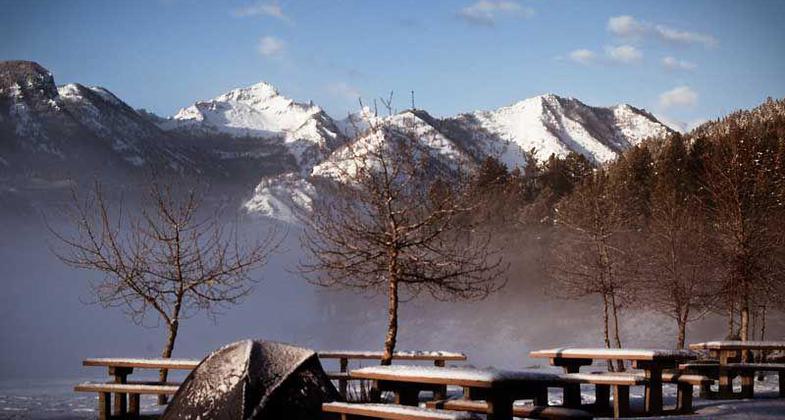
Como Lake Loop National Recreation Trail in Montana, 60 miles south of Missoula; photo by Ida Koric.

Missouri Gold views the lake and snow capped mountains. Photo by Colleen Long.
Location: 60 miles south of Missoula, MT, In Bitteroot National Forest west of U.S. Highway 93, northeast of Darby.
- States: Montana
- Counties: Ravalli
Lake Como National Recreational Loop Trail extends around the lake for seven miles and includes a pack bridge across Rock Creek. The trail is popular for hiking, day use, and mountain biking. Maintained yearly. Trail classified as easy. The trail travels around the Lake. North Shore travel by foot only. Stock use is allowed on the south shore that leads to the Rock Creek Trail. The North side of the trail is suitable for use by persons with crutches and/or braces.
Lake Como National Recreation Trailhead has parking for 17 vehicles, an accessible toilet, picnic tables, pedestal grills, and water. Trailhead accesses a paved quarter-mile interpretative trail. A half mile after that is unpaved, lakeside picnic sites, and the seven-mile Lake Como National Recreation Trail.
Accessibility Information
No text provided.
Allowed Uses:
Equestrian Hiking/Walking Snow, cross-country skiing Snow, snowshoeingOther Activities
- Camping
- Fishing
- Snow, snow play general
- Wildlife viewing / observation
Public Contact
Nick HazelbakerUS Forest Service
1801 North F6735 West Fk. Rd.
Darby, MT 59829
Contact the trail manager for current maps and visiting details.
More Details
- Elevation (low): 4300
- Elevation (high): 4400
- Elevation (cumulative): --
- Part of a Trail System? No
- Surface (primary): Soil
- Surfaces (additional): Soil
- Tread Width (average): 24"
- Tread Width (minimum): --
- Running length (minimum): --
- Tread Grade (average, percent): 10
- Tread Grade (maximum): 10
- Running length (maximum): --
- Cross-slope (average, percent): --
- Cross-slope (maximum): --
- Running length (maximum): --
- Certified as an NRT
Feb 6, 1979