Columns of the Giants NRT
check with the trail manager for updated details before visiting.
Columns of the Giants NRT
USDA Forest Service
Backcountry Trail
- Length
0.5 miles
- Elevation Gain
--
- Route Type
out & back
- Length
0.5 miles - Elevation Gain
-- - Route Type
out & back
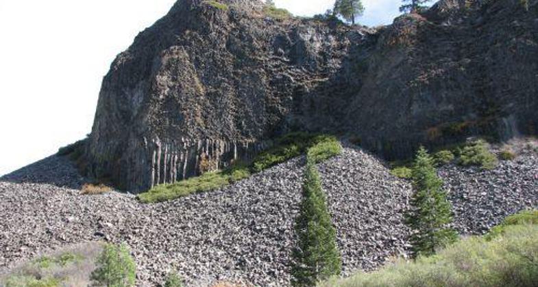
The Columns of the Giants is an interpretive site that highlights a unique geological formation of columnar basalt, very similar to the Devils Postpile National Monument.

Location: In the Brightman Recreation Area of the Stanislaus National Forest, just off SR 108, 54 miles east of Sonora, CA.
- States: California
- Counties: Tuolumne
This self-guided half-mile paved trail reveals a brief chapter in the dynamic history of the Sierra Nevada. Volcanic activity occurred five to ten million years ago and changed the landscape forever. Lava flowing down the ancient Stanislaus riverbed pooled behind a natural dam. As it slowly cooled, it split into multi-sided vertical columns. Later, a glacier flowed down the valley, carving through the volcanic layers and exposing the columns. Unique to this site is a remnant glacier beneath the talus slope.
There are vault toilets available near the parking area. Trails lead to a bridge which crosses over the Middle Fork of the Stanislaus River on the way to view the geologic formation. Interpretive panels along the way illustrate the story of the Columns of the Giants.
Accessibility Information
No text provided.
Allowed Uses:
Swimming Dogs, on leash Hiking/WalkingOther Activities
- Camping
- Fishing
Public Contact
Karen CaldwellStanislaus National Forest
#1 Pinecrest Lake Rd.
Pinecrest, CA 95364
[email protected] • (209) 965-3434
www.fs.fed.us/r5/stanislau
Contact the trail manager for current maps and visiting details.
More Details
- Elevation (low): 6000
- Elevation (high): 6000
- Elevation (cumulative): --
- Part of a Trail System? No
- Surface (primary): Paved
- Surfaces (additional): Paved
- Tread Width (average): 36"
- Tread Width (minimum): --
- Running length (minimum): --
- Tread Grade (average, percent): 5
- Tread Grade (maximum): 5
- Running length (maximum): --
- Cross-slope (average, percent): --
- Cross-slope (maximum): --
- Running length (maximum): --
- Certified as an NRT
Nov 15, 1979