Coeur d'Alene River Trail
This information is a public record of the 1978 NRT application and may be out of date if it has not been updated by a trail manager --
check with the trail manager for updated details before visiting.
check with the trail manager for updated details before visiting.
Coeur d'Alene River Trail
USDA Forest Service
Backcountry Trail
- Length
14.6 miles
- Elevation Gain
--
- Route Type
out & back
- Length
14.6 miles - Elevation Gain
-- - Route Type
out & back

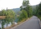
Trail of the Coeur d'Alenes as it follows the river in Idaho. Photo by Todd Murray/wiki.
Location: In Coeur d'Alene National Forest off Forest Road 208 from Kingston exit on Interstate 90.
- States: Idaho
- Counties: Kootenai, Shoshone
Trail 20 is located in the Coeur d' Alene River drainage and offers outstanding fishing for native cutthroat trout.
Accessibility Information
No text provided.
Allowed Uses:
Bicycling EquestrianOther Activities
- Camping
- Fishing
Public Contact
Mike KnodelUS Forest Service
Fernan Ranger District
Coeur d' Alene, ID 83814
(208) 769-3000
Contact the trail manager for current maps and visiting details.
More Details
- Elevation (low): 2830
- Elevation (high): 3380
- Elevation (cumulative): --
- Part of a Trail System? No
- National Designations: Community Millennium
- Surface (primary): Soil
- Surfaces (additional): Soil
- Tread Width (average): 24"
- Tread Width (minimum): --
- Running length (minimum): --
- Tread Grade (average, percent): 8
- Tread Grade (maximum): 15
- Running length (maximum): --
- Cross-slope (average, percent): --
- Cross-slope (maximum): --
- Running length (maximum): --
- Certified as an NRT
Jun 4, 1978