Coalinga Mineral Springs
check with the trail manager for updated details before visiting.
Coalinga Mineral Springs
Bureau of Land Management
Backcountry Trail
- Length
2.75 miles
- Elevation Gain
--
- Route Type
out & back
- Length
2.75 miles - Elevation Gain
-- - Route Type
out & back
The Coalinga Mineral Springs National Recreation Trail is a 5.5 mile roundtrip trail that highlights a mixed chaparral-foothill woodland community where visitors will encounter digger pine, chamise, manzanita, yucca, and many other shrubs and annual wildflowers.
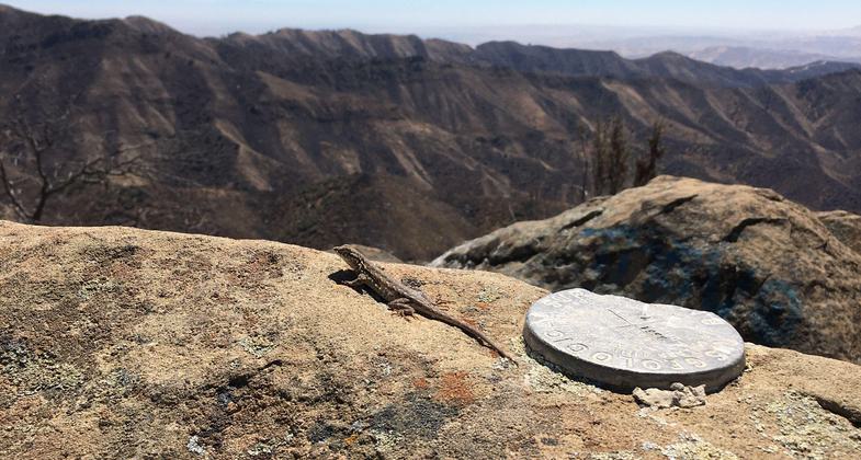
A lizards view from Kreyenhagen Peak. Photo by Adam Wilde.

Looking towards Coalinga from Kreyenhagen Peak. Photo by Dale Johnson.


Location: On Bureau of Land Management land near Coalinga Mineral Springs County Park
- States: California
- Counties: Fresno
The Coalinga Mineral Springs National Recreation Trail is a 5.5-mile roundtrip trail that highlights a mixed chaparral-foothill woodland community where visitors will encounter digger pine, chamise, manzanita, yucca, and many other shrubs and annual wildflowers. Located 18 miles west of Coalinga, CA on Highway 198, the trail is centrally located between Fresno, Bakersfield, and San Jose and is within a 2.5-hour driving distance of more than two million people.
Hikers and equestrians alike enjoy the scenic views along the trail, with the payoff coming at end of the trail at the top of Kreyenhagen Peak. Scanning the scenery, you may be able to spot some of the historic structures near springs that drew many people to the area in the late 1800s. (Please note: there are no existing historic structures located on BLM Public lands; please enjoy from afar.) The trail is open year-round, however, because of the hot summers, visitors will find it more enjoyable during the fall and spring months. The trail is exposed most of the way and there are no facilities along the trail except for directional signs, so it is advised to bring water for the trip. Wildlife is present throughout the Coalinga Mineral Springs National Recreation Trail that can be enjoyed by sportsmen and naturalists. The list of species that can be seen includes the California mule deer, quail, squirrels, mourning dove, feral pig, grey fox, and bobcat.
Accessibility Information
No text provided.
Allowed Uses:
Equestrian Hiking/WalkingOther Activities
- Wildlife viewing / observation
Public Contact
Adam WildeBureau of Land Management
Central Coast Field Office
Marina, CA 93933
[email protected] • (831) 582-2200
www.blm.gov/office/central-coast-field-office
Contact the trail manager for current maps and visiting details.
More Details
- Elevation (low): 2105
- Elevation (high): 3494
- Elevation (cumulative): --
- Part of a Trail System? No
- Surface (primary): Soil
- Surfaces (additional): --
- Tread Width (average): 24"
- Tread Width (minimum): 18
- Running length (minimum): --
- Tread Grade (average, percent): 7
- Tread Grade (maximum): 12
- Running length (maximum): --
- Cross-slope (average, percent): 3
- Cross-slope (maximum): --
- Running length (maximum): --
- Certified as an NRT
Jul 8, 1982