Clear Creek Trail
This information is a public record of the 2007 NRT application and may be out of date if it has not been updated by a trail manager --
check with the trail manager for updated details before visiting.
check with the trail manager for updated details before visiting.
Clear Creek Trail
City, Town, or County
Frontcountry Trail
Urban Trail
- Length
6.5 miles
- Elevation Gain
--
- Route Type
out & back
- Length
6.5 miles - Elevation Gain
-- - Route Type
out & back
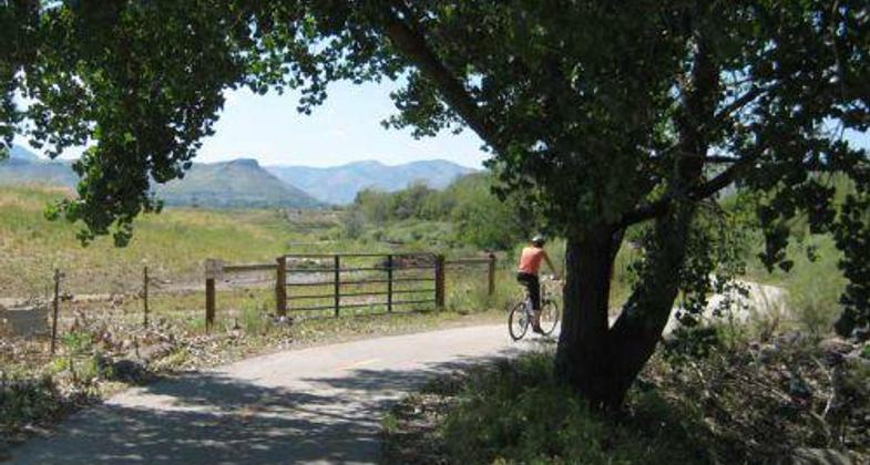
Clear Creek Trail looking west towards Golden.

Bike/ped bridge over Clear Creek. Photo by Hagen Hammons.

Bike/ped bridge along Clear Creek Trail with North Table Mesa in background. Photo by Hagen Hammons.

Bikers on bridge. Photo by Margaret Paget.
Location: Wheat Ridge, Follows Clear Creek south of Interstate 70 in Wheat Ridge. Many access points.
- States: Colorado
- Counties: Jefferson
The Clear Creek Trail winds its way through five miles of the Wheat Ridge Greenbelt from Youngfield Street to Harlan Street. Long portions of the Clear Creek Trail hug the creek margin and lends to the feeling of passing through an eastern forest unusually for the arid climate of the Colorado Front Range. This no-fee trail is accessible to everyone and passes by four lakes providing bonus opportunities for both bird and wildlife viewing by trail users.
Accessibility Information
No text provided.
Allowed Uses:
Bicycling Dogs, on leash Equestrian Hiking/WalkingOther Activities
- Fishing
Public Contact
Margaret PagetCity of Wheat Ridge
7500 W. 29th Ave.
Wheat Ridge, CO 80033
[email protected] • (303) 205-7554
www.ci.wheatridge.co.u
Contact the trail manager for current maps and visiting details.
More Details
- Elevation (low): 5280
- Elevation (high): 5450
- Elevation (cumulative): --
- Part of a Trail System? No
- National Designations: Community Millenium
- Surface (primary): Paved
- Surfaces (additional): Paved
- Tread Width (average): 120"
- Tread Width (minimum): --
- Running length (minimum): --
- Tread Grade (average, percent): 2
- Tread Grade (maximum): 5
- Running length (maximum): --
- Cross-slope (average, percent): --
- Cross-slope (maximum): --
- Running length (maximum): --
- Certified as an NRT
May 31, 2007