Chilco Mountain Trail
This information is a public record of the 1982 NRT application and may be out of date if it has not been updated by a trail manager --
check with the trail manager for updated details before visiting.
check with the trail manager for updated details before visiting.
Chilco Mountain Trail
USDA Forest Service
Backcountry Trail
- Length
6.4 miles
- Elevation Gain
--
- Route Type
out & back
- Length
6.4 miles - Elevation Gain
-- - Route Type
out & back

Location: CDA National Forest, Fernan RD, approx.. 30 miles from Coeur d'Alene.
- States: Idaho
- Counties: Bonner, Kootenai
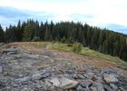
Chilco Trail #14 provides access to two of the highest summits in the Fernan Ranger District. There is no potable water, several good overnight campsites at the top in the saddle between the North and South Chilco Mountains. Great view of the Purcell Trench, Coeur d' Alene, Cabinet, and Selkirk Mountain Ranges.
Accessibility Information
No text provided.
Allowed Uses:
Bicycling Hiking/WalkingPublic Contact
USDA Forest ServiceFernan Ranger District
Coeur d'Alene, ID 83814
[email protected] • (208) 664-2318
Contact the trail manager for current maps and visiting details.
More Details
- Elevation (low): 4320
- Elevation (high): 5365
- Elevation (cumulative): --
- Part of a Trail System? No
- National Designations: National Millennium
- Surface (primary): Soil
- Surfaces (additional): --
- Tread Width (average): 30"
- Tread Width (minimum): --
- Running length (minimum): --
- Tread Grade (average, percent): 20
- Tread Grade (maximum): 35
- Running length (maximum): --
- Cross-slope (average, percent): --
- Cross-slope (maximum): --
- Running length (maximum): --
- Certified as an NRT
Oct 24, 1982