Chichaqua Valley Trail
check with the trail manager for updated details before visiting.
Chichaqua Valley Trail
City, Town, or County
Frontcountry Trail
Rail Trail
- Length
20 miles
- Elevation Gain
--
- Route Type
out & back
- Length
20 miles - Elevation Gain
-- - Route Type
out & back
Chichaqua Valley Trail"” This 20-mile rail-trail is rich in both history and scenic beauty, connecting several small towns in Jasper and Polk Counties and allowing for a variety of trail uses including biking, snowshoeing, and bird watching (designated 2007).

Location: Bondurant to Baxter, northeast of Des Moines, railtrail links Bondurant to Baxter.
- States: Iowa
- Counties: Jasper, Polk
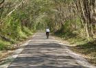
A trip on the Chichaqua Valley Trail is as rich in scenic beauty as it is in history. Tall grass prairie once flooded the valley. Buffalo roamed the landscape and wild onion lined the riverbanks. It was the strong smell of the onion that prompted the Fox Indians to name the river Chichaqua- interpreted as "Skunk", which probably referred to the wild onions. While the area no longer carries buffalo or retains the overwhelming odor of skunk, a ride on the Chichaqua Valley Trail gives visitors the complete illustrative range of Iowa's natural land. The twenty-mile route is constructed on a converted railroad bed. It connects several small towns along the Chichaqua Bottoms Greenbelt just as the railroad did many years ago.
The Chichaqua Valley Trail was built in 1987, four years after the Chicago Northwestern Railway abandoned the corridor. The alignment has seen many rail lines over the past 100 years including the Wisconsin, Iowa, and Nebraska Railroad; Chicago, St. Paul, and Kansas City Railroad; and the Chicago Great Western Railroad. Traces of all of these companies can still be seen on the route. Families can begin their trip at the northeast end of Baxter. The trailhead hosts a fully restored caboose that users can visit to view additional railroad memorabilia. As users continue down the trail they will cross several stone bridges built in 1885 during the initial railroad construction. Whistle crossings and mile markers still spot the corridor declaring the distance to Kansas City.
Plan your trip accordingly. The slope of the Chichaqua Valley Trail is very gentle due to the railroad bed it is constructed on. This makes it a great trail for beginners and families. The route crosses through open farmland, rolling meadows, and forested river valleys. The western portion of the trail is shaded by tree arches. Midway along the trail, a long wooden railroad trestle crosses the Skunk River, which is the backbone of the 7000-acre Chichaqua Bottoms Greenbelt conservation area. The River bridge has pull-out areas where users can stop to admire the tranquil Skunk River and Greenbelt. Nowhere else in Iowa do trail users have the access to such an extensive natural area. Polk and Jasper County Conservation Boards are working together to restore the Greenbelt to its native prairie, wetland, and savanna landscape.
The paved surface of the Chichaqua Valley Trail allows for a variety of uses including skating, hiking, running, and bicycling. In the winter, the trail is open to snowshoeing and cross-county skiing. Bird watching is a major attraction to the area. A variety of wetland fowl such as Blue Herons, egrets, and pelicans can be spotted on the trail. Many species of woodland birds can be enjoyed by enthusiasts as well. Wildflower photography and geocaching are also popular activities in the area.
Accessibility Information
No text provided.
Allowed Uses:
Bicycling Dogs, on leash Hiking/WalkingPublic Contact
Keri VanZanetJasper and Polk County Conservation Boards
115 N. 2nd Ave E
Newton, IA 50208
[email protected] • (641) 792-9780
www.conservationboard.org
Contact the trail manager for current maps and visiting details.
More Details
- Elevation (low): 795
- Elevation (high): 1000
- Elevation (cumulative): --
- Part of a Trail System? No
- Surface (primary): Paved
- Surfaces (additional): Paved
- Tread Width (average): 108"
- Tread Width (minimum): --
- Running length (minimum): --
- Tread Grade (average, percent): 2
- Tread Grade (maximum): 3
- Running length (maximum): --
- Cross-slope (average, percent): --
- Cross-slope (maximum): --
- Running length (maximum): --
- Certified as an NRT
May 31, 2007