Cedar Grove Trail
check with the trail manager for updated details before visiting.
Cedar Grove Trail
USDA Forest Service
Backcountry Trail
- Length
1 mile
- Elevation Gain
--
- Route Type
out & back
- Length
1 mile - Elevation Gain
-- - Route Type
out & back
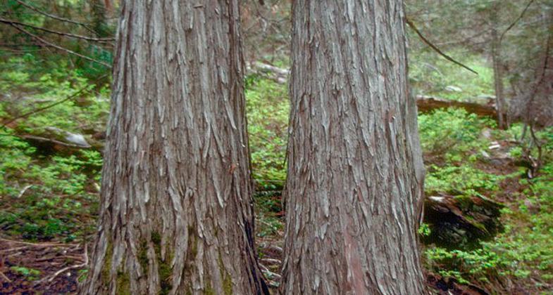
The Cedar Grove Botanical Area covers about 26 acres and contains the only isolated stand of Alaska yellow cedar east of the Cascades in the United States. This grove, located on the northeast slope of Aldrich Mountain at the head of Buck Cabin Creek, offers a cool, welcome respite from the heat of a hot, desert-like summer day.
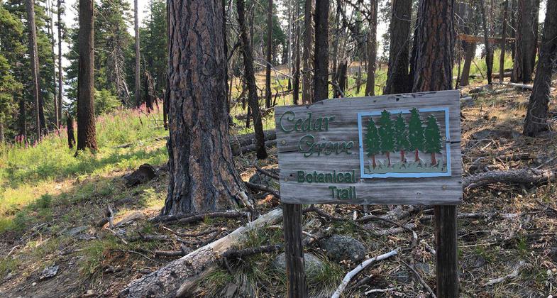
Cedar Grove Botanical Area. Photo by Chandra LeGue.

Cedar Grove Botanical Area, Aldrich Mountains, Malheur National Forest, Grant County, Oregon. Photo by USFS.
Location: In Malheur National Forest at Cedar Grove Roadless Area southwest of Mt. Vernon.
- States: Oregon
- Counties: Grant
The Cedar Grove Botanical Area in the Aldrich Mountains covers about 26 acres and contains the only isolated stand of Alaska yellow cedar east of the Cascades in the United States. This grove is located on the northeast slope of Aldrich Mountain at the head of Buck Cabin Creek. This species is normally found at scattered locations in the Cascades and along the North Pacific coast.
Experts believe that during pre-glacial times in Oregon, the climate here was much cooler and more humid. At that time, perhaps during the late Pleistocene, this stand may well have been part of a contiguous stand of cedar. Because of the unique combination of weather, moisture, and other conditions in this one isolated spot, this small stand survived changes to hotter, drier weather. Most areas were converted to ponderosa pine and the other trees we see in eastern Oregon today. The cedar grove offers a cool, welcome respite from the heat of a hot, desert-like summer day. A National Recreation Trail provides fairly easy access into the grove for visitors.
The cedar grove is located along a very wet area of springs and seeps and is found amid a larger stand of true firs and Douglas-fir trees, along with some ponderosa pine and western larch. Dark and cool, it is fairly open underneath the trees, with not much undergrowth of shrubs and other vegetation. Some of the current cedar trees are more than 300 years old. This area endured a large lightning-caused wildfire, and small cedar seedlings give promise for the continued existence of this part of prehistoric Oregon.
You can find the Cedar Grove Botanical Area by driving south on Forest Service Road 21 (Fields Creek Road) off Highway 26, about 10 miles west of Mt. Vernon. When you reach Fields Creek summit, turn right and follow the Forest Service Road 2150 for about five miles west to the trailhead. The trail is only one mile long. It crosses a broad ridge, then descends a timbered slope and ends in a short loop through the grove of Alaska yellow cedars. Parts of the trail are steep and rough as it passes through a dense fir forest and large rock outcroppings.
Accessibility Information
No text provided.
Allowed Uses:
Hiking/WalkingOther Activities
- Wildlife viewing / observation
Public Contact
Robin MurrayMalheur National Forest
P.O. Box 849
John Day, OR 97845
(541) 575-1731
Contact the trail manager for current maps and visiting details.
More Details
- Elevation (low): --
- Elevation (high): --
- Elevation (cumulative): --
- Part of a Trail System? No
- Surface (primary): --
- Surfaces (additional): --
- Tread Width (average): 0"
- Tread Width (minimum): --
- Running length (minimum): --
- Tread Grade (average, percent): --
- Tread Grade (maximum):
- Running length (maximum): --
- Cross-slope (average, percent): --
- Cross-slope (maximum): --
- Running length (maximum): --
- Certified as an NRT
Feb 6, 1979