Catwalk Trail
check with the trail manager for updated details before visiting.
Catwalk Trail
USDA Forest Service
Backcountry Trail
- Length
1.35 miles
- Elevation Gain
--
- Route Type
out & back
- Length
1.35 miles - Elevation Gain
-- - Route Type
out & back
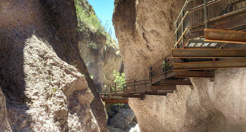
Photo by Amber Wisley.

Winner 2022 NRT Photo Contest, Innovative Facilities. Photo by William Ribbans, NM Wild.

Photo by Amber Wisley.

Photo by Amber Wisley.

Photo by Amber Wisley.

Photo by Amber Wisley.

Photo by Amber Wisley.

Photo by Amber Wisley.

Photo by Amber Wisley.

Mary J. Collins.
Location: Glenwood Ranger District, 6 miles from Glenwood on U.S. Highway 180 in Whitewater Canyon.
- States: New Mexico
- Counties: Catron
"Whitewater Canyon is an incredibly beautiful place, and along with the Catwalk are important contributions to New Mexico's vast array of scenic wonders, both natural and man-made," said Fred Peralta, secretary of the New Mexico Tourism Department. "The legendary efforts on the part of local and Federal officials to make the Catwalk an experience not to be missed are to be commended."
There is little to remind the modern visitor to the Gila National Forest that a century or so ago life here was full of danger and uncertainty. Struggles raged between the resident Apaches and the newcomers-prospectors, miners, settlers, soldiers, and over-land travelers. Miners, who discovered bonanzas in gold and silver in the Mogollons, never strayed far from their weapons.
Whitewater Canyon was a central point in the mining saga. The town of Graham, also called Whitewater, grew up around a mill built by John T. Graham in 1893. The town survived less than 10 years.
Construction of the water lines was an engineering feat that probably would not be attempted today. Brace holes were drilled into the solid rock walls - sometimes 20 feet above the canyon floor - to hold timbers and iron bars that supported the small waterline along its meandering course. Old records show that the large iron waterline was in constant need of maintenance.
Workmen who had to walk the line to repair damage dubbed it the"Catwalk." All that remains to mark the spot are several huge wooden beams and part of the mill walls clinging to the west side of the canyon near the entrance to the Catwalk. The mines above the canyon were worked from their discovery in 1889 until 1942.
Whitewater Canyon presented special mining and milling problems to the Helen Mining Co., the first developer of claims about four miles upstream from the site of Graham and the mill. The mill, powered mainly by electricity, could not be built closer to the mines because of the rough and narrow canyon. While the stream frequently dried up at the mill site, it ran almost continuously on the high mountains where the mines were located. Despite the large investment of time and money, Graham Mill was never highly successful. Periodic episodes of flooding and, allegedly, mismanagement kept the mill from flourishing. It was finally closed in 1913. The massive rock walls of Whitewater Canyon saw few visitors until the 1930s when the Civilian Conservation Corps was assigned the task of rebuilding the 18-inch water pipeline.
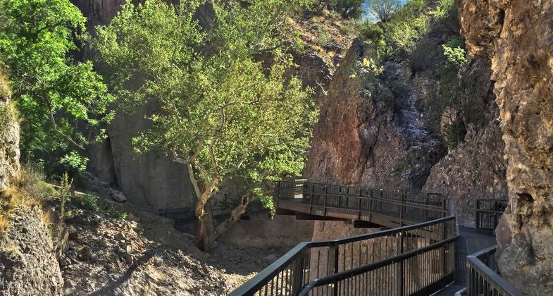
Each year the Catwalk becomes more popular with visitors to the Gila. Thousands take the walk along the cool and colorful Whitewater Canyon. There are no camping facilities at the Catwalk; however, there are picnicking facilities at the Whitewater Picnic Grounds.
The Catwalk National Scenic Trail hours are 8 a.m. to 5:30 p.m. daily.
Accessibility Information
No text provided.
Allowed Uses:
Dogs, on leash Hiking/WalkingOther Activities
- Fishing
Public Contact
Glenwood Ranger DistrictP.O. Box 8
Glenwood, NM 88039
[email protected] • (575) 539-2481
Contact the trail manager for current maps and visiting details.
More Details
- Elevation (low): 5150
- Elevation (high): 5450
- Elevation (cumulative): --
- Part of a Trail System? No
- Surface (primary): Soil
- Surfaces (additional): Boardwalk
- Tread Width (average): 40"
- Tread Width (minimum): --
- Running length (minimum): --
- Tread Grade (average, percent): 6
- Tread Grade (maximum): 15
- Running length (maximum): --
- Cross-slope (average, percent): --
- Cross-slope (maximum): --
- Running length (maximum): --
- Certified as an NRT
Dec 17, 1978