Cascades Trail
This information is a public record of the 1976 NRT application and may be out of date if it has not been updated by a trail manager --
check with the trail manager for updated details before visiting.
check with the trail manager for updated details before visiting.
Cascades Trail
USDA Forest Service
Backcountry Trail
- Length
3.9 miles
- Elevation Gain
--
- Route Type
out & back
- Length
3.9 miles - Elevation Gain
-- - Route Type
out & back
Location: NE of Pearisburg, at N end of county rd. 623.
- States: Virginia
- Counties: Giles
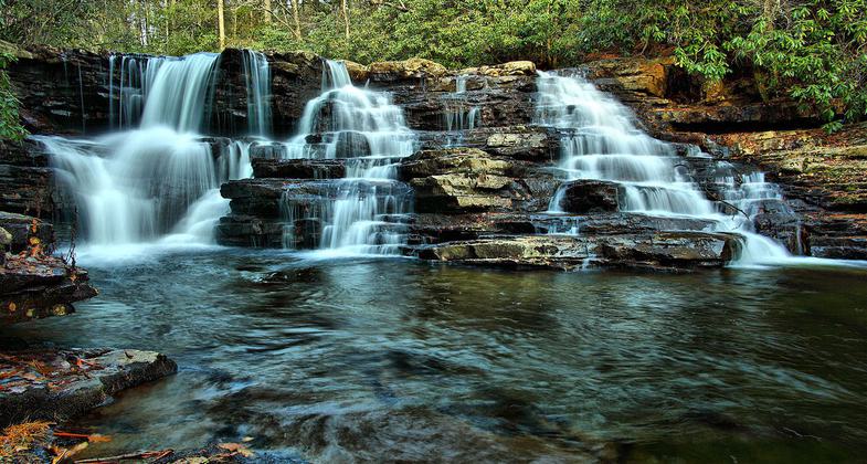
Cascades Day Use Area is one of the most popular outdoor recreation spots in southwest Virginia. It features shady picnic spots, a native trout stream, and a 4-mile scenic loop trail. The main attraction is the scenic 66 foot Cascade Falls, a dramatic waterfall located two miles from the parking area.
Accessibility Information
No text provided.
Allowed Uses:
Dogs, on leashOther Activities
- Fishing
Public Contact
George Washington & Jefferson National ForestEastern Divide Ranger District
Blacksburg, VA 24060
[email protected] • (888) 241-6669
www.fs.usda.gov/gwj
Contact the trail manager for current maps and visiting details.
More Details
- Elevation (low): 2150
- Elevation (high): 2900
- Elevation (cumulative): --
- Part of a Trail System? No
- Surface (primary): --
- Surfaces (additional): --
- Tread Width (average): 24"
- Tread Width (minimum): --
- Running length (minimum): --
- Tread Grade (average, percent): 8
- Tread Grade (maximum):
- Running length (maximum): --
- Cross-slope (average, percent): --
- Cross-slope (maximum): --
- Running length (maximum): --
- Certified as an NRT
May 31, 1976