Cannon Valley Trail
check with the trail manager for updated details before visiting.
Cannon Valley Trail
Commission
Rail Trail
- Length
20 miles
- Elevation Gain
--
- Route Type
out & back
- Length
20 miles - Elevation Gain
-- - Route Type
out & back
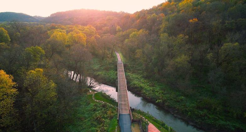
The Cannon Valley Trail is a 19.7 mile long trail that runs through diverse and spectacular scenery on a former Chicago Great Western Railroad line connecting the cities of Cannon Falls, Welch and Red Wing in beautiful southeastern Minnesota.


Location: A Railtrail connecting the cities of Cannon Falls, Welch and Red Wing in beautiful southeastern Minnesota.
- States: Minnesota
- Counties: Goodhue
- Cities/Townships: Cannon Falls, Welch, Red Wing
The Cannon Valley Trail is a 19.7-mile long trail that runs through diverse and spectacular scenery on a former Chicago Great Western Railroad line connecting the cities of Cannon Falls, Welch, and Red Wing in beautiful southeastern Minnesota.
Paralleling the Cannon River, the Trail offers glimpses and panoramas of the valley and gradually descends 115 feet in elevation from Cannon Falls to Red Wing. From overhanging cliffs to views of extensive wetland complexes, nature's seasonal changes are vividly displayed.
The Trail is open year-round for bicycling, in-line skating, skateboarding, similar wheeled recreational devices, hiking, walking, and cross-country skiing. Trail users age 18 or older must have a valid Wheel Pass when using the trail from April 1-November 1. The Great Minnesota Ski Pass is required to cross-country ski on the Cannon Valley Trail.
Accessibility Information
No text provided.
Allowed Uses:
Bicycling Snow, cross-country skiing Snow, snowshoeingOther Activities
- Snow, snow play general
- Wildlife viewing / observation
Public Contact
Scott RoepkeCannon Valley Trail Joint Powers Board
825 Cannon River Avenue
Cannon Falls, MN 55009
[email protected] • 507-263-0508
Contact the trail manager for current maps and visiting details.
More Details
- Elevation (low): 700
- Elevation (high): 815
- Elevation (cumulative): --
- Part of a Trail System? No
- Surface (primary): Paved
- Surfaces (additional): --
- Tread Width (average): 96"
- Tread Width (minimum): 96
- Running length (minimum): --
- Tread Grade (average, percent): 1
- Tread Grade (maximum): 2
- Running length (maximum): --
- Cross-slope (average, percent): 0
- Cross-slope (maximum): --
- Running length (maximum): --
- Certified as an NRT
May 16, 2018