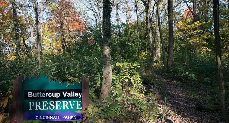
Buttercup Valley Trail
check with the trail manager for updated details before visiting.
Buttercup Valley Trail
City, Town, or County
Frontcountry Trail
Urban Trail
- Length
1 mile
- Elevation Gain
--
- Route Type
out & back
- Length
1 mile - Elevation Gain
-- - Route Type
out & back
Buttercup Valley is located in the neighborhood of Northside in Cincinnati.
Location: On slopes just north of downtown Cincinnati (recert'd 1991).
- States: Ohio
It is just one of the many nature preserves the city has to offer. Attached to Buttercup Valley is Parker's preserve which offers two trails: a paved trail and a woodland trail. The Parker's Preserve trails are great for the beginning hiker or someone looking for a small walk through the woods.
Buttercup Valley offers more intense hiking for the avid nature hiker. It has some steep inclines and very wooded trails. These trails will make you forget you're still in the city. Buttercup Valley runs from West, Hamilton Avenue to East on Crawford Avenue. One trail will take you to an area called the Flats which is a meadow or prairie habitat. Another trail will take you right to a clearing and to Crawford Avenue. You can see Spring Grove Cemetery.
Buttercup Valley is a beautiful piece of forest which has been untouched since the pioneer days. Some of the trees in the valley are over 200 years old! It is home to various flora and fauna. Buttercup Valley is a hiker's dream nestled in the heart of urban neighborhoods. It is Northside's gem.
The Board of Park Commissioners in 1973 received 21.21 acres of land at the east end of Stanford Drive and Northview Drive, and a .63 acre tract at the corner of Craven Avenue and Fergus Street in the community of Northside for use as a nature preserve. The natural preserve, was a gift from the Greater Cincinnati Tree Council, conservationists, thousands of school children, the Park Board, and others. Buttercup Valley was dedicated on Arbor Day, April 26, 1974, with many children from schools attending since they had participated in the collection of funds to acquire the land.
Through a further donation of funds in 1974 by the Greater Cincinnati Tree Council and a Land and Water Conservation Fund grant from the Federal Bureau of Outdoor Recreation, additional acreage was purchased for a current total of 25.667 acres. These funds also provided for development of a hiking trail. The Buttercup Valley Trail was designated as a National Recreation Trail by the U.S. Department of the Interior in 1979.
Accessibility Information
No text provided.
Allowed Uses:
Hiking/WalkingPublic Contact
Cincinnati Park Board950 Eden Park Dr.
Cincinnati, OH 45202
Contact the trail manager for current maps and visiting details.
More Details
- Elevation (low): --
- Elevation (high): --
- Elevation (cumulative): --
- Part of a Trail System? No
- Surface (primary): Paved
- Surfaces (additional): --
- Tread Width (average): 0"
- Tread Width (minimum): --
- Running length (minimum): --
- Tread Grade (average, percent): --
- Tread Grade (maximum):
- Running length (maximum): --
- Cross-slope (average, percent): --
- Cross-slope (maximum): --
- Running length (maximum): --
- Certified as an NRT
Sep 17, 1979