Burr Oak Nature Trail
This information is a public record of the 1983 NRT application and may be out of date if it has not been updated by a trail manager --
check with the trail manager for updated details before visiting.
check with the trail manager for updated details before visiting.
Burr Oak Nature Trail
U.S. Corps of Engineers
Backcountry Trail
- Length
0.75 miles
- Elevation Gain
--
- Route Type
out & back
- Length
0.75 miles - Elevation Gain
-- - Route Type
out & back
The Bur Oak Nature Trail is a 3/4-mile nature walk located below the dam and adjacent to Sylvan Park.
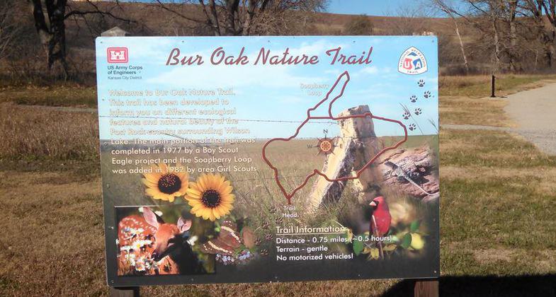
Location: At Wilson Lake, just below Wilson Dam off SR 232 10 mi. N of I-70.
- States: Kansas
- Counties: Russell
The trail provides visitors with a better understanding of the area's ecology. A brochure describing the stops along the trail is available at the trail head. The Corps of Engineers Office and Information Center located on the northeast corner of the dam has additional brochures concerning Wilson Lake and other Corps lakes. The main portion of the trail was competed in 1977 by a Boy Scout Eagle project. The Soapberry Loop was added in 1982 by area Girl Scouts.
Accessibility Information
No text provided.
Allowed Uses:
Hiking/WalkingPublic Contact
Dennis ArcherUS Army Corps of Engineers
Wilson Project Office, RR 1
Sylvan Grove, KS 67481
[email protected] • (785) 658-2551
Contact the trail manager for current maps and visiting details.
More Details
- Elevation (low): --
- Elevation (high): --
- Elevation (cumulative): --
- Part of a Trail System? No
- Surface (primary): Rock, crushed
- Surfaces (additional): Rock, crushed
- Tread Width (average): 72"
- Tread Width (minimum): --
- Running length (minimum): --
- Tread Grade (average, percent): --
- Tread Grade (maximum):
- Running length (maximum): --
- Cross-slope (average, percent): --
- Cross-slope (maximum): --
- Running length (maximum): --
- Certified as an NRT
Aug 11, 1983