Brownsville Historic Battlefield Trail
check with the trail manager for updated details before visiting.
Brownsville Historic Battlefield Trail
City, Town, or County
Urban Trail
- Length
9 miles
- Elevation Gain
--
- Route Type
out & back
- Length
9 miles - Elevation Gain
-- - Route Type
out & back
Brownsville Historic Battlefield Trail is a safe 9-mile hike and bike path that runs south - north directly through the middle of the city. This connection starts at Southern Pacific Linear Park and goes through many residential neighborhoods, public schools, public facilities, commercial businesses, and public transportation. As users travel along the trail, they experience the natural environment of South Texas observing the beauty of the natural resacas, the palm trees, the mesquites, and wildlife.
Trail facing Federal Courthouse.

Beginning of Trail at Linear Park

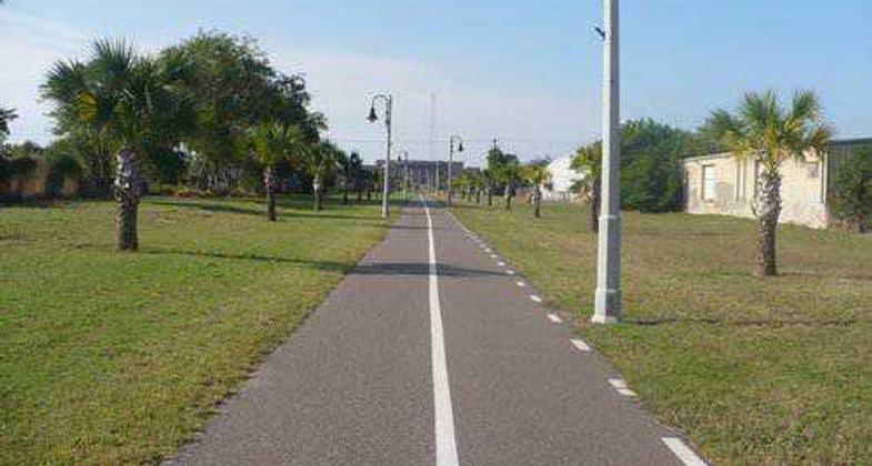
Trail after the Boca Chica Boulevard crossing
Location: The Historical Battlefield Trail begins at Southern Pacific Linear Park between 6th & 7th East Street, along Ringgold Road in the Brownsville Original Townsite and ends north of Brownsville at Palo Alto Battlefield National Historical Park, site of the fi
- States: Texas
- Counties: Cameron
- Cities/Townships: Brownsville
The Historic Battlefield Trail is a safe 9-mile hike and bike path that runs north-south directly through the middle of the city. The rich heritage and history of the Rio Grande Valley is ensconced in this trail. When Texas was annexed by the United States over 160 years ago, the United States became a dominant force in the decade-old dispute between the former Republic of Texas and Mexico over the location- Nueces River or Rio Grande River-of the actual boundary separating the U.S. from Mexico.
Decades later, in 1904, the St. Louis, Brownsville and Mexico Railroad opened a track between Brownsville and Robstown. Historically, the railroad track was used to transport goods from north to south and vice versa. After rail service ceased in 1956, the City of Brownsville purchased the corridor and began the process of establishing Southern Pacific Linear Park as the starting point of the Historic Battlefield Trail.
Now completed, the Southern Pacific Linear Park in historic downtown exposes users to traveling public art exhibits located both inside and outside of the Brownsville Fine Arts Museum. Steps away, is the world-renowned Gladys Porter Zoo, home to over 600 species of animals and plants. Additionally, Dean Porter Park offers the Camille Lightner Playhouse, Children's Museum of Brownsville, Ringgold Civic Pavilion, and Sams Pool.
As the Historical Battlefield Trail continues northeast along Parades Line Road, users can connect to the Neutra House-one of a few homes designed in Texas by world-renowned architect, Richard Neutra. On the stretch between Price Road and FM 802, users have the option of visiting the Resaca de la Palma National Battlefield. Reaching Alton Gloor Boulevard from FM 802, the trail connects a myriad of neighborhoods to the Brownsville Metro Northside Station, the Brownsville Events Center, and the North Brownsville Park and Tennis Center. Here, the Historic Battlefield Trail gives users the option to diverge onto the 7-mile Paseo de la Resaca Trail System which leads to other public facilities such as Hudson Elementary School and the Margaret M. Clark Aquatic Center. Additionally, users can connect to Vela Middle School and Burns Elementary.
Traveling beyond the city environs to Palo Alto Battlefield National Historic Park, users experience the natural environment of South Texas all the while observing the beauty of the natural resacas (former Rio Grande River tributaries), native vegetation, and local wildlife such as chachalacas, great kiskadee, and Altamira orioles.
Beyond the historic and cultural scope of the Historic Battlefield Trail, one of the largest benefits of having this trail is to promote a healthy lifestyle for a community with exorbitant rates of diabetes and obesity. The Brownsville Historic Battlefield Trail is the first of its kind in the region and is envisioned to become the center of a growing network of trails.
Accessibility Information
No text provided.
Allowed Uses:
Bicycling Hiking/WalkingOther Activities
- Heritage and history
- Wildlife viewing / observation
Public Contact
Christopher PattersonCity of Brownsville
1338 E. 8th Street
Brownsville, TX 78520
[email protected] • (956) 548-6000
Contact the trail manager for current maps and visiting details.
More Details
- Elevation (low): --
- Elevation (high): --
- Elevation (cumulative): --
- Part of a Trail System? No
- Surface (primary): Paved
- Surfaces (additional): --
- Tread Width (average): 120"
- Tread Width (minimum): 120
- Running length (minimum): --
- Tread Grade (average, percent): --
- Tread Grade (maximum):
- Running length (maximum): --
- Cross-slope (average, percent): 0
- Cross-slope (maximum): --
- Running length (maximum): --
- Certified as an NRT
May 29, 2013