Bridge Rock Trail
This information is a public record of the 1978 NRT application and may be out of date if it has not been updated by a trail manager --
check with the trail manager for updated details before visiting.
check with the trail manager for updated details before visiting.
Bridge Rock Trail
U.S. Corps of Engineers
- Length
1 mile
- Elevation Gain
--
- Route Type
out & back
(1 review)
- Length
1 mile - Elevation Gain
-- - Route Type
out & back
Location: 15 mi. W of Dardanelle on SR 22.
- States: Arkansas
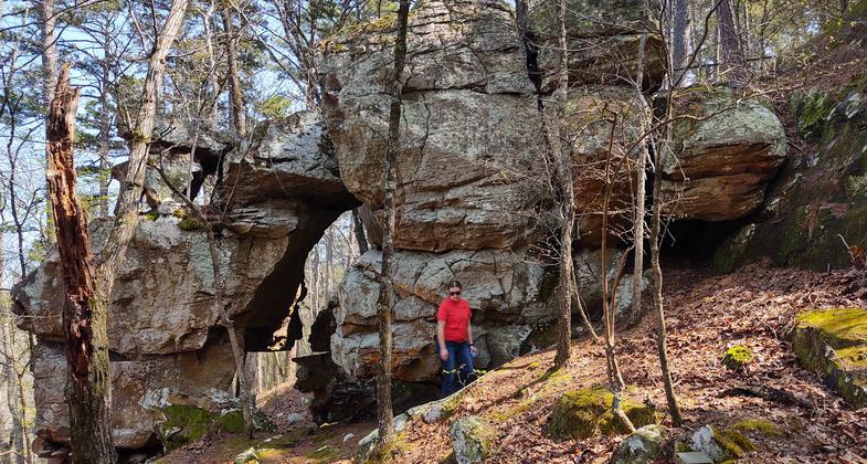
The trail winds along a rugged NW slope overlooking a portion of Shoal Creek. There are three different routes of increasing length and difficulty. The total length is one mile and one hour should be allowed to walk the entire trail. Passes under a unique geological rock arch. Trail markers point out plants, trees, and rock formations. Bridge Rock Trail is a Green Thumb project constructed under the direction of the Corps of Engineers in Shoal Bay Park.
Accessibility Information
No text provided.
Allowed Uses:
Swimming Dogs, on leash Hiking/WalkingOther Activities
- Camping
- Fishing
Public Contact
Allison SmedleyUS Army Corps of Engineers
1598 Lock and Dam Rd
Russelville, AR 72802
[email protected] • (501) 968-5008
Contact the trail manager for current maps and visiting details.
More Details
- Elevation (low): --
- Elevation (high): --
- Elevation (cumulative): --
- Part of a Trail System? No
- Surface (primary): --
- Surfaces (additional): --
- Tread Width (average): 4"
- Tread Width (minimum): --
- Running length (minimum): --
- Tread Grade (average, percent): --
- Tread Grade (maximum):
- Running length (maximum): --
- Cross-slope (average, percent): --
- Cross-slope (maximum): --
- Running length (maximum): --
- Certified as an NRT
Mar 7, 1978