Boulder River Natural Bridge and Falls Trail
check with the trail manager for updated details before visiting.
Boulder River Natural Bridge and Falls Trail
USDA Forest Service
- Length
0.8 miles
- Elevation Gain
--
- Route Type
out & back
(1 review)
- Length
0.8 miles - Elevation Gain
-- - Route Type
out & back
Spectacular geologic natural bridge over the Boulder River.
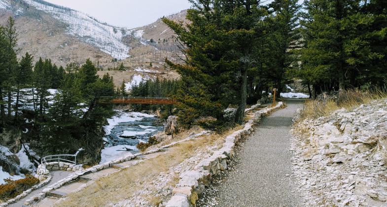
Photo by Kasie Haack.

Boulder river with viewing bridge. Photo by KH.

Across the bridge. Photo by KH.

Picnic area. Photo by KH.

View from the bottom. Photo by KH.

Boulder river. Photo by KH.

Underground river exit. Photo by KH.

Photo by KH.

Parking lot. Photo by Kasie Haack.

Natural Bridge Sign. Photo by Kasie Haack.
Location: Boulder River Canyon
- States: Montana
- Counties: Sweet Grass
Constrained by a deeply cut chasm during high water, the Boulder River flows over a 100-foot precipice, creating the spectacular Natural Bridge Falls. At low water, the river used to flow under a natural rock bridge, but in July 1988, the bridge that gave the area its name collapsed.
The paved pedestrian trail provides great views and interpretive geologic information.
Accessibility Information
No text provided.
Reviews
Kasie Haack
Great Day Hike
The Natural Bridge Falls is a great accessible trail. It is ideal for families, seniors, beginner hikers and plus size hikers. The loop is less then a half mile round trip. The views are spectacular. It's an excellent lunch stop on your way into the Gallatin National Forest.
This visit was done in late March. Most of the path was clear of snow except on some densely tree covered areas. Water flow was less then it is in May and June. Temperature ranged in the high 30's.
Allowed Uses:
Hiking/WalkingPublic Contact
Pete BeckenPO Box 1130
Big Timber, MT 59011
[email protected] • (406) 932-5155
www.fs.fed.us/r1/gallatin
Contact the trail manager for current maps and visiting details.
More Details
- Elevation (low): 5200
- Elevation (high): 5200
- Elevation (cumulative): --
- Part of a Trail System? No
- Surface (primary): Paved
- Surfaces (additional): Paved
- Tread Width (average): 60"
- Tread Width (minimum): --
- Running length (minimum): --
- Tread Grade (average, percent): 7
- Tread Grade (maximum): 10
- Running length (maximum): --
- Cross-slope (average, percent): --
- Cross-slope (maximum): --
- Running length (maximum): --
- Certified as an NRT
Mar 1, 1981