Bohemia Trail
check with the trail manager for updated details before visiting.
Bohemia Trail
USDA Forest Service
Backcountry Trail
- Length
7 miles
- Elevation Gain
--
- Route Type
out & back
- Length
7 miles - Elevation Gain
-- - Route Type
out & back
Location: T 23S, R 1E and T24S R 1E, WM, In Umpqua National Forest, NE of Roseburg off Forest Rd. 2422 (China Lake Rd.)
- States: Oregon
- Counties: Lane, Douglas
The High Divide Trail-Bohemia Section is the remains of the historic Oakland Wagon Road, constructed in 1864-65 to provide gold prospectors and miners access from Oakland, Oregon to the booming Bohemia Mining District. Numerous sections of hand-placed rock wall construction is evident along the remaining seven miles of this route. Two historic trail shelters, constructed by the Civilian Conservation Corps (CCC), are located along the trail and provide an ideal camp or picnic shelter for trail users.
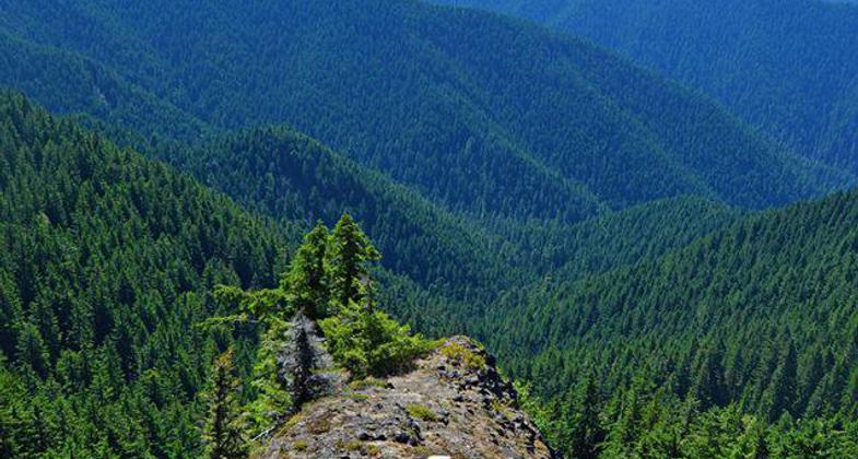
Typically, the trail travels along the remote timbered Calapooya Ridge, a known aboriginal route through the foothills of the Cascade Mountain Range, and passes by several large rock outcrops that provide viewpoints of the forested canyons below. The Bohemia NRT section terminates near Bohemia City, a mining ghost town, while the High Divide Trail route continues to the east along the Calapooya Divide and eventually to the Pacific Crest Trail. However, forest roads have occupied most of these sections with only short trail sections remaining.
Accessibility Information
No text provided.
Allowed Uses:
Bicycling Equestrian Hiking/Walking Motorized vehicles, motorcyclingPublic Contact
Cindy PackUmpqua National Forest
Cottage Grove Ranger District
Cottage Grove, OR 97424
[email protected] • (541) 767-5000
www.fs.fed.us/r6/umpqua/rec/hiking
Contact the trail manager for current maps and visiting details.
More Details
- Elevation (low): 3200
- Elevation (high): 4800
- Elevation (cumulative): --
- Part of a Trail System? No
- Surface (primary): Soil
- Surfaces (additional): Soil
- Tread Width (average): 24"
- Tread Width (minimum): --
- Running length (minimum): --
- Tread Grade (average, percent): 10
- Tread Grade (maximum): 30
- Running length (maximum): --
- Cross-slope (average, percent): --
- Cross-slope (maximum): --
- Running length (maximum): --
- Certified as an NRT
Mar 3, 1981