Bob Woodruff Park and Oak Point Park and Nature Preserve Trails
check with the trail manager for updated details before visiting.
Bob Woodruff Park and Oak Point Park and Nature Preserve Trails
City, Town, or County
Urban Trail
- Length
9.9 miles
- Elevation Gain
--
- Route Type
out & back
- Length
9.9 miles - Elevation Gain
-- - Route Type
out & back
The Bob Woodruff Park and Oak Point Park and Nature Preserve Trails are 9.9 miles of continuous trail that connects two adjacent parks and encompasses a total of 1,100 acres. Functioning as part of a regional trail network, the multi-use trails provide easy access to a number of public facilities including pavilions with cooking grills, a playground, a sand volleyball court, restrooms, an amphitheater, a recreation center, a dog park, two man-made lakes, soft-surface trails, a treetop adventure course, a nature and retreat center, and ample parking.
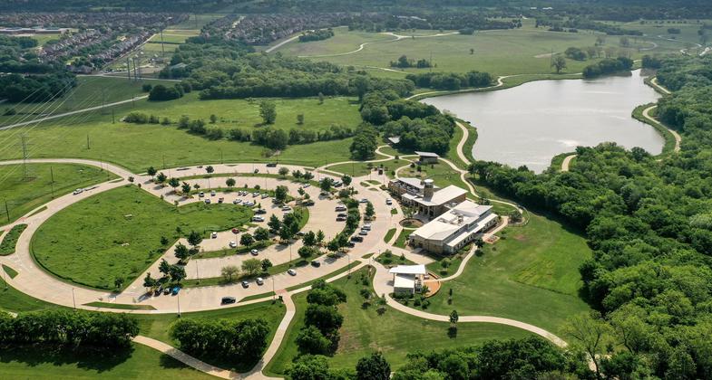
Aerial Photo of Woodruff & Oak Point Trails.

Oak Point Park and Nature Preserve Aerial

Bob Woodruff Park Aerial

Sunrise at Oak Point Park and Nature Preserve

Guided Nature Walk on Boardwalk Portion of Trail

Walker on Boardwalk Portion of Trail

Skater on Trail

Dog Walker on Trail

Runners and Walkers on Trail

Childrens' Run on Trail
Location: Plano, Texas
- States: Texas
- Counties: Collin
- Cities/Townships: Plano
Plano acquired land for Bob Woodruff Park and Oak Point Park and Nature Preserve over many years through numerous purchases and donations. Guided by the Parks and Recreation Master Plan, land acquisition for Bob Woodruff Park spanned 14 years, from 1976 to 1990; while the Oak Point Park and Nature Preserve's land acquisition took 22 years to be fully realized, from 1982 to 2004. Together, the adjoining parks contribute to 25% of Plano's entire park system, encompassing approximately 1,100 acres of protected open space preserve, wetlands, native hardwood forests, and native grasslands.
The trails running through these adjoining parks were envisioned in conjunction with the land acquisition and guided by the City's Bicycle Transportation Plan and the Park Master Plan. Now, they are destination trails, providing opportunities for both active and passive outdoor recreation. Combined, they total 9.9 miles of point-to-point travel, loops, and out-and-back routes
Both trails maintain an average width of 10 feet, with some sections as narrow as eight feet and as wide as 12 feet, and are fully ADA-accessible with a maximum slope of 5%.
Constructed of reinforced concrete, with the exception of a short, elevated section of boardwalk, the trails provide easy access to a number of public facilities including pavilions with cooking grills, a playground, a sand volleyball court, restrooms, an amphitheater, a recreation center, a dog park, two man-made lakes, soft-surface trails, a treetop adventure course, a nature and retreat center, and ample parking.
Bob Woodruff Park and Oak Point Park and Nature Preserve Trails attract a variety of users including bicyclists, runners, walkers, dog walkers, photographers, nature enthusiasts, people in wheelchairs, and people pushing strollers, to name a few. Both trails are truly shared-use paths. The trails are also a desirable and preferred destination for several local outdoor-focused organizations such as the Plano Bicycle Association, Plano Pacers Running Club, and the Plano Balloon Association.
Both trails complement various park activities, including 5K and 10K runs, wildlife observation, photography, fishing, kayaking, stand-up paddle boarding, picnicking, family gatherings, day camps, nature classes, an annual balloon festival, concerts, and zip-line and canopy tours.
Along the trails, users will find informative signage placed at strategic locations. These signs range from directional guides to proper trail etiquette and park rules. There is even interpretive signage about the history, flora, and fauna of the area. Emergency trail markers are also posted along both trails to ensure that first responders can determine exactly where their assistance is needed.
Paved concrete trails within Plano's system have a 25-year to 30-year lifespan. Therefore, the Bob Woodruff Park and Oak Point Park and Nature Preserve Trails are designed and built to last. Their composition, combined with regularly conducted inspections and maintenance, including sweeping and repairs when necessary, help keep the trails in their best possible condition and open year-round. The Parks and Recreation Department is committed to keeping the trails in the best possible condition
Throughout the planning and design process for the Bob Woodruff Park and Oak Point Park and Nature Preserve Trails, planners and residents wanted to ensure that both trails were powerfully integrated within Plano's trail system. This vision became a reality, providing a connection to Plano's Bluebonnet Trail (a National Recreation Trail), Santa Fe Trail, and an on-street bike route system. These connections are significant not only for Plano's trail system but for the North Texas region at large.
Together, the trails are incorporated into the North Texas Regional Veloweb, a 1,883-mile network of shared-use trails for cyclists, pedestrians, and various other forms of active transportation. The Veloweb network includes portions of the 2011 Collin County Regional Trails Master Plan as well as the 2001 Six Cities Trail Plan. These two plans outline a smaller localized trail network within the area near Plano. All of these planning documents serve as a guide to linking the trails throughout the region, with a focus on continuous inter-city trail connections to major destinations.
Even though the Bob Woodruff Park and Oak Point Park and Nature Preserve Trails are fully constructed, there are plans for future connections to other trails within the Plano trail system. These include links to the existing Cottonwood Creek Greenbelt Trail North, which adds 2.6 miles of existing paved trail, as well as the planned Los Rios Park Trail, which will encompass an additional two miles of future paved trail.
The Parks and Recreation Department actively educates and informs trail and park users through the department's website and social media channels including Facebook, Instagram, and Twitter.
With its wide array of activities, family-friendly atmosphere, and environmentally rich natural setting, Plano's Bob Woodruff Park and Oak Point Park and Nature Preserve Trails provide healthy recreational opportunities for people of all ages, interests, skills, and physical abilities.
Accessibility Information
No text provided.
Allowed Uses:
Bicycling Dogs, on leash Hiking/WalkingOther Activities
- Heritage and history
- Wildlife viewing / observation
Public Contact
Doug Braches, Trail System PlannerPlano Parks and Recreation Department
PO Box 860358
Plano, TX 75086
[email protected] • 972-208-8001
www.planoparks.org
Contact the trail manager for current maps and visiting details.
More Details
- Elevation (low): 530
- Elevation (high): 613
- Elevation (cumulative): --
- Part of a Trail System? No
- Surface (primary): Paved
- Surfaces (additional): Boardwalk
- Tread Width (average): 120"
- Tread Width (minimum): 96
- Running length (minimum): --
- Tread Grade (average, percent): 1
- Tread Grade (maximum): 5
- Running length (maximum): --
- Cross-slope (average, percent): 0
- Cross-slope (maximum): --
- Running length (maximum): --
- Certified as an NRT
Jun 2, 2022