Blue Lake
This information is a public record of the 1980 NRT application and may be out of date if it has not been updated by a trail manager --
check with the trail manager for updated details before visiting.
check with the trail manager for updated details before visiting.
Blue Lake
USDA Forest Service
Backcountry Trail
- Length
2.2 miles
- Elevation Gain
--
- Route Type
out & back
- Length
2.2 miles - Elevation Gain
-- - Route Type
out & back
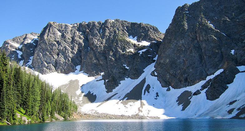
Blue Lake in Okanogan National Forest. Photo by Miguel Vieira at Flickr wiki.

Blue Lake Trail. Photo by Miguel Vieira at Flickr wiki.
Location: W of Washington Pass in Okanogan NF on S side of SR 20.
- States: Washington
- Counties: Okanogan
After leaving the parking lot the trail parallels the road and then climbs the hill in big timber, to scattered larches near the lake. Stocked with cutthroat trout. Beautiful views of mountains
Accessibility Information
No text provided.
Allowed Uses:
Dogs, on leash Hiking/WalkingOther Activities
- Camping
- Fishing
Public Contact
Jim HammerOkanogan National Forest
Methow Valley Ranger District
Winthrop, WA 98862
(509) 996-4017
Contact the trail manager for current maps and visiting details.
More Details
- Elevation (low): --
- Elevation (high): --
- Elevation (cumulative): --
- Part of a Trail System? No
- Surface (primary): --
- Surfaces (additional): --
- Tread Width (average): 18"
- Tread Width (minimum): --
- Running length (minimum): --
- Tread Grade (average, percent): --
- Tread Grade (maximum):
- Running length (maximum): --
- Cross-slope (average, percent): --
- Cross-slope (maximum): --
- Running length (maximum): --
- Certified as an NRT
May 5, 1980