Blackberry Trail
check with the trail manager for updated details before visiting.
Blackberry Trail
National Park Service
Backcountry Trail
- Length
1 mile
- Elevation Gain
--
- Route Type
out & back
- Length
1 mile - Elevation Gain
-- - Route Type
out & back
The Blackberry Trail is located entirely within Mount Rushmore National Memorial. This one mile section of gravel trail connects with the Centennial Trail in the Black Elk Wilderness, a part of the Black Hills National Forest. Mainly used by equestrians, visitors to the Blackberry Trail will have the opportunity to ride or hike in solitude enjoying the trees, birds, and geology along the trail.
Location: In Mount Rushmore National Memorial near Keystone, SD.
- States: South Dakota
- Counties: Pennington
- Cities/Townships: The trail is entirely located within the boundaries of Mount Rushmore National Memorial" a unit of the National Park Se
The Blackberry Trail (approximately one mile in length) is located entirely within Mount Rushmore National Memorial and was recently rehabilitated during the summer of 2016 and spring of 2017. Mainly used by equestrians as a spur trail to access Mount Rushmore, visitors on the Blackberry Trail will have exceptional opportunities to ride or hike in solitude enjoying the trees, birds, and geology of the local area.
The Blackberry Trail is located adjacent to the Mount Rushmore Parking Facility where hikers can begin their exploration. If traveling on horseback, equestrian users may only access the trail from the Black Hills National Forest, at the location where the Blackberry Trail meets the Centennial Trail. This trail junction is located at the boundary between Mount Rushmore National Memorial and the Black Elk Wilderness Area, a part of the Black Hills National Forest. All equestrians should familiarize themselves with the United States Forest Service and wilderness regulations prior to their journey. Visitors who access the trail from the Mount Rushmore Parking Facility will be charged a parking fee.
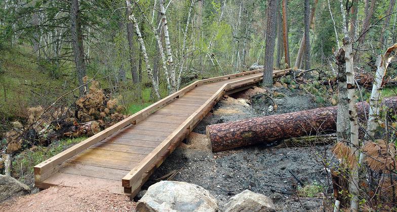
The newly revitalized Blackberry Trail is composed of a crushed gravel trail surface approximately three feet wide and one mile in length. The trail is moderately strenuous in nature and gracefully flows through hilly terrain as well as through many rock outcroppings. A forest composed of ponderosa pine and birch also dominates the landscape along the trail providing exceptional photography opportunities for visitors wishing to seek this unique experience. As the trail leads uphill from the park boundary, the trail winds its way towards Mount Rushmore crossing several small water crossings as well as one wooden plank bridge that is approximately 75 feet long and four feet wide. In addition to providing a unique experience for visitors such as riders or hikers leading to Mount Rushmore National Memorial, many views of Mount Rushmore are available from the pine-studded forest area leading to the memorial, providing additional photography opportunities with the Mount Rushmore sculpture as the backdrop. Additionally, several horse tie-up stations and two picnic tables are provided further enhancing the recreational experience.
Historically, the Blackberry Trail has been heavily used by equestrians. This heavy use coupled with a lack of timely trail maintenance caused erosion and damage to many of the trail features rendering the trail very difficult to navigate. In 2010 an effort and plan was developed by the Mount Rushmore National Memorial Superintendent, working in coordination with the Mount Rushmore Society, a donor, and many other stakeholders to plan for the trail re-design, re-route, and final rehabilitation in 2016-2017. This teamwork and partnerships coordination as well as technical trail guidance from National Park Service engineers, United States Forest Service land managers, the Black Hills Backcountry Horsemen Group of South Dakota, local trail contractors, and many other stakeholders aligned to complete the successful rehabilitation of this significant trail and access point to Mount Rushmore National Memorial. Law enforcement, Interpretation, and Maintenance services are provided by the National Park Service as well as in coordination with local volunteer and youth service groups.
Mount Rushmore National Memorial hopes that visitors will seek the outstanding recreational opportunities and experiences provided by the Blackberry Trail. The trail is well marked and includes an informational kiosk at both the trailhead near the Mount Rushmore Parking Facility as well as near the boundary with the Black Hills National Forest. The trail is open 24 hours per day, 365 days per year and all pets must be on leash at all times. Please note that parking at the Mount Rushmore Parking Facility is available year-round. Please check the Memorial's website www.nps.gov/moru for up-to-date information on parking hours, maps, and directions. We look forward to your visit to Mount Rushmore and hope you enjoy this unique trail experience!
Accessibility Information
No text provided.
Allowed Uses:
Dogs, on leash Equestrian Hiking/WalkingOther Activities
- Heritage and history
- Wildlife viewing / observation
Public Contact
Cheryl SchreierNational Park Service
13000 Highway 244 Building 31, Ste. 1
Keystone, SD 57751
[email protected] • 605-571-1131
Contact the trail manager for current maps and visiting details.
More Details
- Elevation (low): 4868
- Elevation (high): 5182
- Elevation (cumulative): --
- Part of a Trail System? No
- National Designations: not applicable
- State Designations: not applicable
- Surface (primary): Rock, crushed
- Surfaces (additional): Boardwalk, Rock, crushed, Soil
- Tread Width (average): 36"
- Tread Width (minimum): 24
- Running length (minimum): --
- Tread Grade (average, percent): 10
- Tread Grade (maximum): 22
- Running length (maximum): --
- Cross-slope (average, percent): 3
- Cross-slope (maximum): --
- Running length (maximum): --
- Certified as an NRT
May 16, 2018