Black Point Trail
This information is a public record of the 1979 NRT application and may be out of date if it has not been updated by a trail manager --
check with the trail manager for updated details before visiting.
check with the trail manager for updated details before visiting.
Black Point Trail
USDA Forest Service
Backcountry Trail
- Length
0.6 miles
- Elevation Gain
--
- Route Type
out & back
- Length
0.6 miles - Elevation Gain
-- - Route Type
out & back
Location: In Sierra NF at Big Creek. W of Huntington take Huntington Lake Rd. W to Rd. 8S32, follow 4 mi. to trailhead.
- States: California
- Counties: Fresno
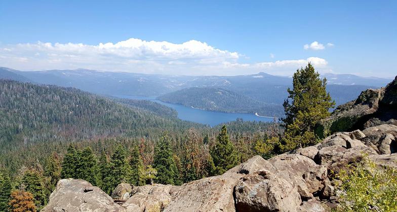
The Black Point National Recreation Trail is 0.6 miles long. It begins at Black Point Trailhead 8s32 and ends at Black Point. The trail is open for hiking. This short trail is a moderate slope. There is only one rocky, steep section, which occurs near the top. The grade is about 20%, but it's a short section, and the view is worth it.
Accessibility Information
No text provided.
Allowed Uses:
Dogs, on leash Hiking/WalkingPublic Contact
Sierra National ForestP.O. Box 559
Prather, CA 93651
(559) 855-5355
Contact the trail manager for current maps and visiting details.
More Details
- Elevation (low): --
- Elevation (high): --
- Elevation (cumulative): --
- Part of a Trail System? No
- Surface (primary): --
- Surfaces (additional): --
- Tread Width (average): 0"
- Tread Width (minimum): --
- Running length (minimum): --
- Tread Grade (average, percent): --
- Tread Grade (maximum):
- Running length (maximum): --
- Cross-slope (average, percent): --
- Cross-slope (maximum): --
- Running length (maximum): --
- Certified as an NRT
Dec 12, 1979